Tag Archives: Peru

…And Boats (well, Boat)…

19th April 2018

The last Major Tourist Thing on our itinerary was a boat ride on Lake Titicaca, proudly calling itself “the highest navigable lake in the world” on the basis that there is a steam ship in the harbour which took two years to assemble from 2,500 parts which were made in England and shipped to Puno by rail over a period of four years. So we’ll give them that, shall we?

As usual with Major Tourist Things, the bloody alarm went off at 0500 so we could catch a boat on the lake. We knew from the comprehensive itinerary that Sunvil had prepared for us that this Major Thing would have two component bits: a visit to the lake-dwelling Uros tribe; and a visit to another island called Taquile where we could wander round (lunch included). Nothing in the descriptions we’d seen prepared us for the utterly absorbing day we experienced.

The waters of Lake Titicaca (pronounced with very strong K sounds and meaning stone (titi) puma or cat (kaka) due to a fanciful interpretation of its shape) are very shallow in the Puno section (there’s a bottleneck caused by a pair of peninsulae which separate it from the main body of the lake). This shallow section hosts a vast area of reeds, which the Uros tribe (a pre-Inca people) used at first to make boats that they could live on which could easily be moved as a defensive tactic. This graduated into the building of rafts and there are now several dozen such rafts which are the location for an entire way of life.

OK; so far, so good. What we were utterly unprepared for was the scale and sophistication of the area. These pictures show you just one side of a channel, and the other side was of the same order of size.

Uros tribe rafts

Here are a couple of video clips, one of each side of the main channel, which I also hope get across the scale of what’s there.

A post shared by Steve Walker (@spwalker2016) on

A post shared by Steve Walker (@spwalker2016) on

We landed on one of the rafts and were treated to a comprehensive education on how the rafts are made.

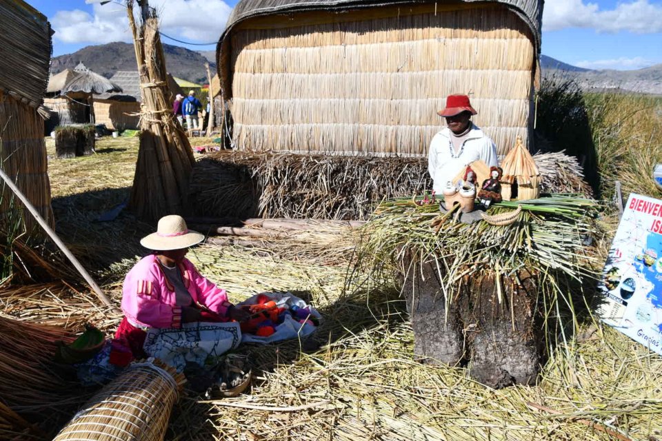
Some day I shall try to make a video about it, but basically what you see in front of you is some approximately one-metre-square chunks of reeds that have been hacked out of the mass of reeds because they have broken free of the mud and started to float. These days the people use large saws to hack out sections, but they used to use much more primitive tools (something like a large, bladed hoe) to do this. They embed sticks into each section which they then bind together – again, today with nylon cord, but originally with rope made from reeds.

The bound sections are then left for a month so the living reeds can grow cross roots bonding the whole thing together; they can then be hauled into place and added into already-extant rafts, after which they’re covered in a reed flooring (about 1 metre of layers placed alternately at right angles to each other) and so are ready for building reed houses on. The flooring has to be continuously renewed as it rots away from the bottom, and so occasionally they have to lift a house, refresh its reed base and replace it. The whole raft is anchored in place to stop them waking up in Bolivia if the weather turns nasty.

It’s very obviously a major undertaking and it takes a lot of maintenance. But the end result is something that can support a group of people consisting of several families.

A post shared by Steve Walker (@spwalker2016) on

(We were told that if a family in a community annoyed everyone else they were simply cut free.) There is a medical centre, school, churches… a population of around 1,000… the mind boggles.

The original tribes lived on boats and it’s clear that boats are still very much part of their culture – apart from anything else, they need to use them to get necessities from the mainland such as fabric for clothing, fruit and veg (although the reeds are edible) and so forth. Some of the boats they build are large (double-decker, in fact) and capable of carrying several people, and are often decorated with ceremonial animals

People aboard an Uris boat

and they are moved by two Uros rowing at the front (as you can see from the first video clip in this post) – at that altitude, they must be really fit!

The Uros people don’t shun modern technology at all – they have solar panels for electricity, for example, although there’s no internet. Tourism is clearly a major source of income, although I gather that the tourist boats that visit them tend to alternate sides of the channel so that individual communities are not beset every day. The people knit and weave and so have produce that they can sell to visitors, but the retail opportunity is nicely managed and not at all importunate. They managed to separate us from a few dollars for something we didn’t really need, but we gladly paid up, as the experience, particularly that of being rowed about on one of their “Mercedes Benz” boats, was so striking and such a pleasure.

The next stage of the day was a visit to a real, solid, island called Taquile which is out into the major part of the lake. We landed at one pier, and embarked on a short hike around the island, on a prepared path, to another pier where our boat was there to meet us. We had to take things quite slowly, as the path was at times steep, and we were at over 3,800m above sea level.

Taquile Landscape

The island is a pleasant place, with much terracing for people to farm crops.

Taquile Landscape

and it’s divided into six neighbourhoods (based around the six families who originally settled the island in Inca times); each neighbourhood is demarcated by a stone arch.

A traditional stone arch

We stopped for lunch at a place which caters only for visitors. The island doesn’t have hotels and restaurants, although people can visit and stay with families to learn aspects of the local ways of life; and families eat at home. But we and other tourists were served a very agreeable lunch of quinoa soup and trout. Before lunch, our guide, Aidee, explained some details of the culture that the island people are working hard to keep active. A key aspect of this culture is the clothing, and there are many things that people wear to show their status or role in the society. All of these things are knitted (by men) or woven (by women) on the island and it was fascinating to learn about them.

Taquile hats and other knitted and woven garments

Above, moving roughly from right to left:

  • A loom which men use to weave belts made from the hair of their fiancee (collected from childhood onwards).
  • A felt hat which signifies a person of authority – mayor, head of council, police, with, underneath it the multi-coloured wollen headpiece signifying that this was the island’s mayor.
  • Above the hat, a shawl, with pom-poms. The pom-poms come in various sizes and levels of flamboyance, depening on whether the woman wearing it is on the lookout for a husband, or is married, etc.
  • Three woollen hats, knitted by the men of the island signifying (from right) a married man, a boy child and a girl child.
  • Among the hats is a part-knitted sample to show how fine the knitting is. We were told that one test a woman can make of a man’s knitting skill, when deciding whether to marry him or not, is to empty water into one of his woollen hats. If the water stays in the hat, he is a fine knitter; if it drains away, he needs to go and practice more.
  • At top left, a colourful bag which married men use to carry coca leaves (used instead of a handshake as greeting).
  • At bottom left, two belts, the upper one woven by a woman from wool and the lower one by a man from human hair. When a man and a woman get married, two of these belts are joined together as a symbol of the union.

The women really do spin wool in the old traditional way, with a spindle, and the men really do knit.

A man knits

This very well-defined culture was as unexpected of the island visit as the scale of the raft society was earlier in the day, and so we made it back to Puno feeling that we’d had a very rich pair of experiences, and that we got very much more out of our last day in South America than just a token piece of tourist activity.

Tomorrow will be Time For The Journey Home. But now it’s Time For The Bar.

Trains (well, train)….

18th April 2018

[Short read but lots of pictures alert]

All too soon our day of leisure in Cusco was over and the relentless tourism resumed with an 0500 alarm set for the next day, all so we could go and catch a train. Not just any old train, though – we would have got up later for that – but the Titicaca train, operated, as is the Machu Picchu service we travelled, by PeruRail, and thus sharing many of the same characteristics – friendly staff, drinks and food on board and a fashion show to try to extract a few extra tourist dollars. However, the journey we were undertaking was a significant one – over 10 hours to cover the 384 kilometres from Cusco across the mountains to Puno, on the shores of Lake, you guessed it, Titicaca. (Starting altitude 3,354m above sea level, finishing at 3,828m and, in the middle, getting up as high as 4,319m – over 14,000 feet, and within a very short spit of 2.7 miles high. By way of comparison, the cabin pressure you experience on a typical jet flight is equivalent to an altitude of 2,000 – 2,500m).

If one has to spend 10 hours on a train going over very significant mountainous terrain, it’s reassuring to know that a full meal (and bar) service is provided, as is an observation car.

Prompt at 0710 we started the journey and it was immediately clear that we were in for some great scenery.

The Titicaca Train rounds a bend

Landscape seen on the Titicaca Train

It was also nice to see the locals waving a friendly greeting as the train went by.

as well as some who were simply gettiing on with the daily grind of, for example, subsistence farming of quinoa,

A farmer with her crop of red quinoa

or llamas

Llamas roaming the plain

which may well have this as their home.

After a short while, the entertainment started in the bar.

and it became clear that the repertoire of traditional Peruvian music stopped at around El Condor Paso (yes, the tune immortalised by Simon and Garfunkel) and tunes such as Hotel California and Sweet Child of Mine were pressed into service – all with some skill and great verve. There was also a dancer

who had at least one costume change and who also got passengers involved in the fun.

And then it was time for the fashion show.

before we had a stop at the highest point, La Raya, where – goodness me! – there was a retail as well as a photo opportunity. My, what a surprise!

Retail opportunity at La Raya

The train stops at La Raya

Then lunch was served and we could all settle in to a nice siesta.

The scenery continued, of course

(the power of prayer clearly being insufficient to hold this church together)

Landscape seen on the Titicaca Train

and then we noticed a bit of a change in the landscape, from the absolutely ubiquitous terracing (e.g. above) to stone-walled corrals

perhaps indicative of a move out of the Inca influence and towards the Titicaca tribes, who it is thought were the first to people the land in Peru, Ecuador and Bolivia. But this was only temporary, and before too long we were back to terracing, so who knows?

As time moved on, the landscape flattened out and we passed all sorts of rural scenes: evidence of oat farming on quite a big scale;

as well as subsistence farming (this is quinoa)

Subsistence farming near Juliaca

and we’re not sure what this chap was carrying.

Adobe is a common building material

and we even saw a couple of flamingoes, something I had never expected.

And then….we hit the outskirts of the major town of the area, Juliaca (whence we shall fly en route home in a couple of days). It was, frankly, dispiriting, with a very scruffy industrial area outside the town

which gave way to an extraordinary scene – a market of sorts, bordering the railway, for what seemed like several kilometres into the town.

The Juliaca railside market
with stalls literally within centimetres of the train as it went by – and even….

…on the track itself! I’ve called it dispiriting, but I guess it’s just how life goes here, and people were calling out cheerily to the train as we went by; they didn’t seem dispirited.

From Juliaca to Puno is flat and uneventful, although you do start to see the incursion of Lake Titicaca as you go along.

The shores of Lake Titicaca in the late afternoon

The shores of Lake Titicaca in the late afternoon

From a brief conversation with a guide, I believe we’ll find out much more about this when we go out on the lake tomorrow. You’ll have to stay tuned to find out, won’t you?

Breathless in Cusco

16th April 2018

After the toils and travails of walking up to Machu Picchu, I was looking forward to some less relentless tourism – a visit to Cusco, the city that was the centre of the Inca empire in its glory days.

The journey from Machu Picchu involved once again catching the train to Ollantaytambo, where we had a chat with a couple from Bristol who were nearer the start of their South American adventure than the end. Remarkably, the train staff, having served drinks and snacks, then staged a fashion show with a view to selling us some fine examples of Andean costumery. I bet no-one told them about this sort of thing during careers guidance at school.

The train journey was followed by two hours of purgatory in a taxi. The driver seemed to be a devotee of a particularly tedious variant of traditional Peruvian music which he started playing to us, unasked. It involved a low-quality synthesised guitar/harp/keyboard background to a couple of guys who mainly shouted things like “Ariba!”, “chicos!”, “Cusco!”, “senoritas”, “cerveza!” and so on, and who very rarely actually sang anything recognisable as a tune. At every change of track, I prayed for some variety, but no – tempo, key and harmonic structure, involving just two chords, carried on unabated. I hope the driver enjoyed the music, otherwise there were three of us in the car who hated the music.

Since Cusco’s altitude, at 3,400m above sea level, is somewhat higher than anything I’d experienced before, I was expecting perforce to have to take things gently. In the event, I didn’t suffer from altitude sickness – but I did suffer from altitude. The visit’s prospect of a full day at leisure, something that we’d come to realise is important to factor in to long holidays such as ours, was thus very alluring.

However, we still had to be ready at 0830 to be taken on a guided tour of the city and its environs – who says tourism is relaxing, eh? We were reunited with Camila, our Sacred Valley guide, and she started off by taking us up to Cristo Blanco – the white statue of Jesus Christ which oversees the city. The site offers an excellent view over Cusco.

Cusco - City View

After this, we went to the nearby Inca site of Saqsaywaman. This was a citadel, with sections originally built by the Killke people, with the Incas adding to it from the 13th century. It’s a large site, with two temples either side of a huge plaza, large enough to hold several thousand people for ceremonial occasions. This is a panorama across the huge main Temple of the Sun, taken from the other temple on the site.

(Note: I had to walk up about 30 largish Inca-style steps to bring you this photo, at the top of which I had to sit down for a couple of minutes, since this site is at 3,700m altitude. So, thank you. Thank you for appreciating the effort I’ve had to make to bring you this educational piece.)

As you can see, the main temple is very substantial (indeed, the whole site occupies some 3,000 hectares). The wall is some 400 metres long, and the estimated volume of stone in the temple is 6,000 cubic metres. The stones in the bottom layers of that wall are vast, with the largest estimated to weigh 125 tonnes.

Saqsaywaman - Inca stonework

and yet, you can clearly see the precision with which the stones have been fitted together, with no mortar, and no room even to slide a piece of paper between the stones. The precision of construction and the intricacy of interlocking design are thought to have been the reasons that the site has survived Cusco’s various devastating earthquakes.

To remind visitors that there was doubtless a ceremonial aspect to the site involving the sacrifice of llamas, there are camelids on the site, in this case alpacas, both long- and short-haired varieties; we were particularly taken with this cute little one which can only have been days old.

After the visit to Saqsaywaman, it was time to head back into Cusco proper, where Camila took us to a well-known market called San Pedro (in the square outside St. Peter’s Church).

Before going in, she warned us to take only essential items, as the risk of pickpockets was high.

The San Pedro market was similar in concept to the San Francisco market we’d visited in Quito – organised in sections and with a food court – but much larger and more crowded (hence better turf for pickpockets, I suppose – at any rate we escaped unscathed in that respect). Like all such markets it’s very interesting, varied and colourful.

San Pedro Market Scene

San Pedro Market Scene

San Pedro Market Scene

San Pedro Market Scene

San Pedro Market Scene

There are plenty of stalls offering fabrics and clothes; and if they don’t have your size, they can easily make adjustments for you there and then.

San Pedro Market Scene

San Pedro Market Scene

As well as the official stallholders, there are people selling from ad hoc locations just sitting on the floor (they need the relevant stallholder’s permission to do this). This one, for example, was selling cuy (guinea pig), and you could take your pick – raw or cooked!

San Pedro Market Scene

After the bustle of the market, it was time to make things more thoughtful and spiritual, with a visit to a major temple site in Cusco, called Qorichanka. This was the most important temple in the Inca empire (of which Cusco was the capital, as you’ll know, because you’ve been keeping up).

Church of Santa Domingo

Since this can roughly be translated as “the place with gold”, you’ll not be surprised to learn that it was pillaged by the Spanish when they arrived. Indeed, having stolen the gold, they destroyed much of what was left in building the Church of San Domingo which stands there now. However, some of the original Inca stonework survives, and, indeed supports parts of the church.

Qorikancha Temples of the Sun and Moon

There were three temples on the original site – the Temple of the Sun, the Temple of the Moon and the Temple of Venus and the Stars. The type of stonework was the most sophisticated and labour-intensive sort, called ashlar masonry, involving cuboid blocks of similar size, fashioned to the most exacting standards in order to fit together with complete precision.

Qorikancha Temples of the Sun and Moon

Here you can see the precision involved; even though the lines of the stone are not necessarily completely straight, the fit is as snug as a very snug thing indeed.

Qorikancha Temples of the Sun and Moon

and the precision of alignment of the various components very high.

Qorikancha Temples of the Sun and Moon

This was why the Inca remains have survived Cusco’s devastating earthquakes, whereas the church has had to be rebuilt. Hah!

Camila pointed out one other feature which underlined how clever the Incas were. As I say, the stonework was made to great precision (indeed, modern “experts” have failed to disassemble the remnants of the temple stonework without damage, trying to understand how the ashlar masonry worked, and have been unable to reassemble it with the original precision).

Qorikancha Temples of the Sun and Moon

The protuberance top left is actually part of a sundial, very carefully calibrated to allow the Incas to understand the time and the seasons. Clever chaps, the Incas.

We were allowed to photograph as much of the Inca work as we liked, but prohibited from photographing the colonial/catholic religious parts of the site. In theory this is out of respect (cameras can be noisy in use; and there is nothing in the world of photography more dispiriting than seeing someone waving a selfie stick around in a place of worship) and possibly because camera flash light can be damaging, and there are (too many) people in this world who don’t even realise that their camera is using flash, far less understand how to stop it doing so. In practice, I actually believe it’s so they can sell you postcards.

The next place we visited, and the final one on our tour, was the cathedral, on the (handsome) main square of Cusco.

No, they don’t let you take photos inside there, either, so this is all you get. However, we were amused by the stories that Camila told us of the rivalry between the cathedral (left, above) and the Franciscan church (the other slab of masonry in the photo). There was politial point scoring on every side, with the cathedral having to add elaborate decoration on the front and a dome on top to match the (very ritzy) façade and dome of the Franciscan church; to add two other chapels to make it larger than the Franciscan church; and to forbid the Franciscans from using a part of the building for religious purposes to limit the size of the Franciscan church so that the cathedral was actually larger.

Despite not being able to do anything without sitting down and taking a rest every few minutes, despite the occasionally ridiculous and noisy traffic and despite the difficulty sleeping because of the resonant quality of the hotel plumbing and/or the barking dogs, I liked Cusco a lot. It felt safer, it was more compact, and it had more history to be explored than other South American cities and it has been a pleasure to be here.

A train, a boat and planes lie between us and going home, so stay tuned. But for now it’s time for lunch. (Time For The Bar happened about halfway through the above.)