Sunday 19 September 2021 – today had been built up as being The Big One, the Tough Day; short, only 8.63km, (or just over 5 miles in Brexit currency) with steep climbs (28%) and descents (32%), so we were a bit apprehensive about whether we’d be Found Out and have to be airlifted off in some dire emergency situation.

We also had a couple of “gently uphill” kilometres to do at the end to get to where the Cami360 folk could pick us up and whiz us to our next overnight accommodation. Plus, it had rained very heavily during the night and didn’t immediately show signs of stopping…
There was a certain amount of dickering about the schedule, not least because of the triathlon planned for the day (which you remember from yesterday’s thrilling instalment). In fact, as we were about to leave, cyclists were whizzing past on the main road near our hotel

and our pick up was slightly delayed because of road closures in support of the event.
The practical upshot of all that bdickering was that we could only be picked up at the far end of our walk at 3pm. So we would have a generous amount of time, 5½ hours, to complete the total 11-odd kilometres. The morning’s forecast was for cloudy and cool weather, which, frankly, suited us fine.
By the way, if you want just to see a summary of the following guff, you can watch it on Relive.
We had a robust breakfast; the accommodation might have been basic, but there was muesli for me and plain yogurt for Jane and toast and Marmite an’ everyfink. The same lass (Maria, we think) who picked us up from Binimel-là took us back there along the same horribly bumpy track

with the big difference this time being an almost total lack of cars. When we left yesterday, on a sunny Saturday afternoon, the track above was packed with cars parked along it. Today? Not so much so.

It had stopped raining as we retraced our steps to the end of yesterday’s stage and the start of today’s

and it was, indeed, cool – and windy! We stumbled across the sandy (and, it has to be said, smelly, possibly from rotting seaweed) beach to the official start post for The Big Day.

We passed some evidence that there might have been human habitation


(though why you’d want to live somewhere with no mobile signal is beyond me), past some great rocky scenery

and came to the first steepish bit.

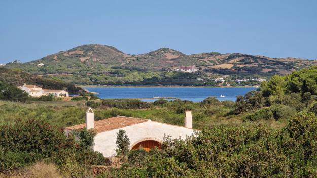
The view from the top was nice enough

and the path abruptly led to a complete change of scene

followed equally quickly by another.

Before too long, we came to an uphill stretch that was a lot more industrial strength

with some interesting rock formations along it.


We did actually scramble up this bit, but honesty compels me to admit that we might have missed the approved path somewhere around here, as we had to adjust our course to get back to the posts that marked the track. So that was exciting. And once we got back onto the True Path, still quite steep.

(You’ll notice that a lot of the photos today are in portrait orientation – that’s tall, rather than wide. I prefer landscape, which is the other way round, but rather a lot of the scenes needed height in the picture, as you’ll see if when you read on.)
The view from the top? Not too bad.

Once up, the path led past some interesting greenish-tinged rocks

before starting another uphill stretch.

Of course, once you get up a steep bit, what happens? You have to go down the other side. Experienced walkers (including this Walker) know that going down is often actually harder work than going up – maybe less puff needed, but more strain on bits of the anatomy such as ankle, quads and knees.

The goal of the path is a gate you can just about make out, far below us, at the far end of this cove. Looking back, one can see it’s quite a steep descent.

If you look carefully at the top horizon, you can just about see a marker post telling you where the descent started.
At the gate, there is an indication of progress along the stage.

Referring back to the chart at the beginning of this screed will tell you that the previous toil was simply a warm-up and the hard work is about to begin. You’ll also have noticed, being observant types, the shadow on the sign which tells you that, yes, the sun has come out and is once again shining fit to split any paving stones it can find, accompanied by a lovely cooling (but stiff) breeze. This meant I had to dig out the hat I’d fervently hoped not to need today. It did a good job of keeping the sun off my head, but only because I spent most of the time clutching on to it because it kept trying to blow off in the strong winds (the hat, not my head…). Anyway, back to the mainstream of today’s symposium….
So: up we go again

and down a bit

and then up a bit more. Quite a lot more, actually.


Once at the top, the path passes a mystery object, perhaps from the island’s Talaolitic past?
 (either that, or some hikers decided to build a cairn and got a bit carried away). We tried to find some information about it, but there was no internet, so we just carried on. And, of course, down – the track led alongside the wall in this picture.

and then down some more.

before the very last uphill pull of this part of the track.

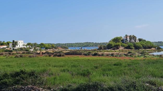
which takes you into yet another change of scenery – farmland.

There was even a farm building; deserted, but recently-used, to judge by the fresh straw outside it.

Very soon after this, we got to the end of the stage. Phew!

(Notice that the sign says “Ets Alocs”, which for some linguistic reason far beyond my ken is different from the official name for the place, Es Alocs. But it suited my purpose to use in the title.)
As it happens, neither of us felt that the stage was as difficult as it had been made out to be. Yes, it was tough and steep in places (definitely not suitable for anyone with vertigo!), but it wasn’t exhausting and didn’t feel too much harder work than yesterday.
Any feelings of satisfaction about a good job well jobbed, though, were abruptly snuffed out by the knowledge that we still have over 2km to walk to get to where we could be picked up, following a forest track

along which we walked to the finish.

It may have been “gently uphill”, but it was not a rewarding surface to toil up in the unrelenting sun and it adds an interesting twist to the end of the day’s walking as recorded by my Garmin device.

So we ended up a little higher than one of the high points of the walk! Not only that, but we had over an hour to wait for our pick up. There was no mobile signal to contact them, but in any case it had been made fairly clear that the schedule couldn’t be altered. So we found a shady spot to rest and eat a couple of apples while we waited. Eventually, some 10 minutes early, Philip from the Cami360 team came along and so we were able to get to our overnight accommodation, the Aparthotel Loar, where rather pleasantly we didn’t have to explain about Ms Hayward; they were ready for us, even having our bags stored for us in a locker, and so we were able to get to a shower and some moments relaxation with minimum fuss.
Since we had an apartment room, with cooker and fridge, we were looking forward to going out to have a Nice Lunch somewhere and to buy some milk and other provisions in a supermarket. Wrapped as we were in the happy haze of Being On Holiday, we had, though, forgotten that it was Sunday. All the restaurants shut at 4pm until 7.30 earliest, and the supermarket was closed until tomorrow. Thus we had to make do with a beer/juice (delete as appropriate) in the bar and retreated to our room to hope that the bread, butter and ham that we’d bought back in Arenal, so many, many days ago (OK, only three) was still fit for human consumption having been bumped around in a suitcase all that time. So, ham and Marmite sandwiches it was, but at least we could get some milk from the bar for a Nice Cup Of Tea, which was very welcome.
The bar was quite noisy, and the source of the din was a couple of tables of old geezers, playing cards

and dominoes – something I haven’t seen for ages!

Our room is perfectly nice, with a decent amount of room and a tiny balcony which gives out on to a decent view.

We’re about to go down to the bar for beer and crisps, because we know how to have a good time, but I thought I’d leave you with the stats of the day.
- 8.26 miles walked
- 486 metres climbed
- Cumulative distance is therefore just over 48 miles in 5 days
- My Garmin tells me that this stage consumed 1320 calories, which is couple of hundred more than yesterday’s 8.35 miles. So, yes it was tougher, but yes not that much tougher.
Tomorrow’s walk sees us take on two stages, 7 and 8. The total distance is about 15km, which means we’ll be walking 17 by the time we have to trek down to the start. On paper it should be a little easier than today, but there’s rain in the forecast as it stands at the moment. We’ll find out as the day unfolds, and I’ll report back in these pages, where I hope you’ll join me once again.