Tag Archives: Surrey

Day 13 – Camintosh: wet weather gear needed!

Cami-flage Day 13Wednesday 23rd September 2020

And so to the final day of our Cami-flage walks. From the weather perspective Menorca has the last laugh; our expectations were set low by the Met Office weather app – correctly so, as it turns out.

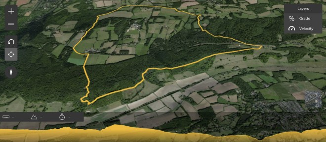
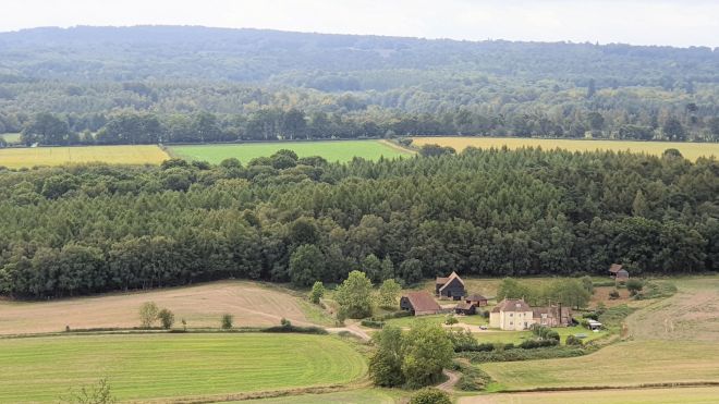
Our final walk was a round trip from Denbies Hillside and up round Ranmore Common; a shorter walk of about 8 miles.

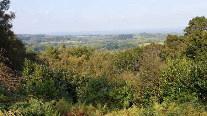
(Dorking is just off to the right in the image.)

The walk started with a great view over the North Downs

(I have a confession to make – I have titivated some of these photos to make them a little less dull and more colourful; the above is an example. So one or two are not exactly as they came from the phone.)

We soon joined the North Downs Way, which at this point is a long, long straight path.

That’s a magnified view along it, Here’s what it really looked like.

Long and straight. It passes several great views such as these

which are, of course, enhanced by having a gin bottle in them.

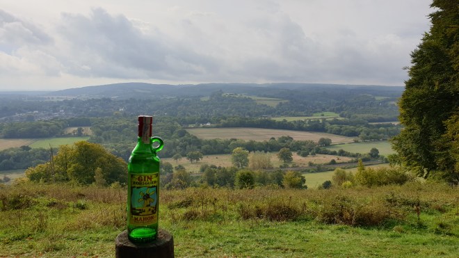
If you have better eyesight than mine, you can even see Leith Hill tower on the horizon.

It’s a very enjoyable trail to stomp along. It reminds me of a story about a lady who used to keep herself fit by going for an exhilarating tramp in the woods every day. She died unexpectedly, and her family were really cross with her when they discovered she had left all her money to the exhilarating tramp.

As we walked along, we could hear some very loud crashing, bashing and gnashing. We eventually came across a very industrial strength bit of forestry kit in use beside the path,

although it rather looked like it was Forest 1 – Human 0, as the driver was seen getting some huge spanners out in order to do something arcane to the crashing-bashing-gnashing appendage on the front.

This is a very splendid forest trail, with some great groves of beech and yew trees along it

and a precipitous drop to the left in places.

It is part of the North Downs Way, which is some 153 miles long.

We passed a wartime pillbox or two

and some spectacular views

before turning off it and heading up to a major forestry trail

alongside which was evidence of some pretty major forestry having taken place. After a while, we emerged at a house called, for some bizarre reason, Red Gables.

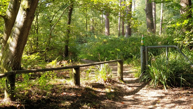
before heading back into woodland. The path was not always clear.

but we found ways round and debouched on to Effingham Golf Course (I wonder if if it’s called that because of all the Effingham Blinding that goes on when a golfer hits a bad shot?).

We passed a “Neo-Tudor” pile called Robinswood

which seemed an obvious place to stage another gin bottle shot.

As we crossed fields on the edge of Ranmore Common, we could sort of make out London in the distance.

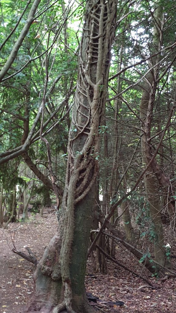
A short dive into woodland revealed the merciless nature of ivy’s grip once it gets established.

And as we emerged, blinking, into open countryside once again, it started raining, albeit not too heavily.

We passed a viewpoint over Polesden Lacey House

which seemed a good place for our final gin bottle shot of the not-holiday.

The final stretch took us into forest, which offered some protection from the rain: first beech;

then oak. It really was quite dark in the looming weather.

A final dash along Ranmore Common Road got us to the car before we became too bedraggled so that we could take ourselves off to Denbies Wine Estate for a Nice Lunch in the Gallery Restaurant. After today’s 7.93 miles we had something, after all, to celebrate.

13 walks in 13 days; 121.12 miles covered (6 miles more than would have been needed in Menorca); 3,623 metres of elevation gained (943 more than the Menorca total); and no injuries – we both feel that we could just carry on.

One reason not to carry on is actually the amount of time it takes up – not just the walking, but also the writing of the blog posts. I’ve hugely enjoyed all aspects of the last 13 days – yes, even the uphill bits – and writing about them has been wonderful, as I haven’t had an excuse to update this blog for ages. But we’ve acquired a bit of a backlog of Real Life Things that needs to be dealt with, so a few days of not walking will ease the pressure. But there’s a nice 18-mile walk that looks tempting for early next week; 9 miles along the canal to Weybridge, a Nice Lunch and then 9 miles back again, trying not to fall in.

I will add a couple of posts to the blog over the next days: a general wrap-up of our impressions of the fortnight; and a specific exposition of my thoughts on having used nothing but a mobile phone camera for the photography (OK, a drone, twice, but you get my thrust, here). So I hope to see you back here in some days. In the meantime, thanks for joining us on these walks and see you soon!

Day 12 – Cami towards the end; Day 12 of 13

Cami-flage Day 12 Tuesday 22nd September 2020

Today is the penultimate day of our substitute walking holiday, where (sorry, this is like a Channel 4 programme after an ad break where they have to remind you what’s going on) we decided to recreate a pandemic-cancelled holiday walking round the outside of Menorca on the Cami de Cavalls by doing equivalent distances in England. Over the previous 11 days, we have walked over 102 miles in lovely late Summer/early Autumn English weather, instead of sweating our way up and down foreign hills in nasty 30-degree heat. Today would appear to be the last day for which this is true.

The outlook for our walk today is sunny, but clouding over (as opposed to the risk of rain in Menorca, nah, nah-ni, nah nah). However, our luck may run out tomorrow.

Anyway, today our walk takes us to the other end of the Surrey Hills from yesterday – Haslemere.

(We start at bottom left and walk the loop counter-clockwise.) Haslemere seems to sit at the junction between the Surrey Hills and the South Downs, if the sign outside the station is to be believed.

We decided to park the car by the station, despite the station car park’s very confusing signage about it being only appropriate for season ticket holders, or something like that.  Whatever, it didn’t look as if we would have trouble finding a space.

We walked along Lower Street, which was radically different from the previous time we saw it when we did this walk last, which was in July this year, not quite three months ago.  Today, it looked like this.

But when we came before, it was a radically different proposition for traffic and pedestrians alike.

Haslemere is a handsome town with some lovely buildings.  I think there must have been a tile factory nearby, or a really good tile salesman, since hanging tiles are a frequently chosen decorative option.  The High Street is a good example of its handsomeness.

The eponymous Church of St. Bartholomew

has a positively baronial vicarage!

We soon cleared the town into some open countryside

where a barn showed, once again, the approach of Autumn in the colours in the creepers across the roof.

We reckon that it won’t be long before the Russian Vine and Virginia Creeper play a degree of havoc with some of the wiring.

One thing that becomes very clear very quickly is that Haslemere backs on to some substantial hills.  Our path wound upwards quite abruptly, and rather steeply.

The path we followed is part of the Greensand Way, a long-distance path that covers Kent and Surrey.  The Long Distance Walkers’ Association (no relation) describe it as “challenging”

and, frankly, if you’d tried to get any kind of vehicle up that path, you’d certainly have faced some challenges.

Once up, there’s a short stretch of open country

before going down again. There are some very fine views to behold

before going, you guessed it, up again, on the final pull up to the Devil’s Punchbowl, where one finds the eponymous Hotel.

This is a fine building, which contains a pub, but we courageously walked past it and merely decided it would be a good backdrop for the first gin bottle shot of the day.

It’s right on the old A3, for those who, like me, remember the days before the Hindhead Tunnel. The Devil’s Punchbowl itself is a geological feature, a massive fold in the landscape with a visitor centre, walking trails and that. There’s a great view

(and a café, from which we gratefully purchased tea and cake).

Moving on took us past more lovely views; this is my attempt at an arty shot of hillsides receding into the haze.

There’s heathland

which gives opportunities for gin bottle shots

and we shortly arrived at the highest point of the walk, the top of Gibbet Hill, the second-highest point in Surrey (the highest being Leith Hill – but you knew that because you were paying attention to my earlier posts, weren’t you?) which provides more spectacular views

and opportunities for gin bottle shots.

There’s a Celtic Cross there

which was erected to attempt to dispel fears of the ghosts of the people who were hanged there on the gibbet which charmingly gave its name to the place.

Thence, the path goes, unsurprisingly, down

eventually passing the site of the Temple of the Four Winds, marked now by just its platform,

by which are some more great views

and a further gin bottle shot opportunity.  Well, it would be rude not to, wouldn’t it?

Continuing down, the path goes past a wonderful grove of beech trees with roots exposed

and thence to a place where there’s clearly been some pretty extreme forestry – really quite an extraordinary scene.

After that, we passed Halcyon House, which, I guess, is in Kingfisher colours (today I learned that Halcyon is the genus of the Kingfisher)

and which has a lovely garden with a duckpond. But we didn’t see any kingfishers.

We greeted the lady of the house cheerily as we walked by, but she rather grumpily ignored us, presumably fed up with Bloody Tourists; but, then again, why buy a place like that with a path going through it, eh? Eh? Answer me that, then.

Continuing down took us by some newish-but-nicely-done cottages

into Grayswood, a very pleasant village on the fringes of Haslemere.  It has a handsome church,

village green,

eccentrically-decorated tree

and some lovely villagey houses, including this arty one.

The route we took, which is part of the Explore Surrey section on Alltrails.com, then takes another final loop out into the country.  We passed a Hammer Pond, so-called because it’s so deep that if you drop a hammer into it, you’ll never get it back.

(Actually, I made that bit up; a hammer pond is merely a body of water that was used to drive a waterwheel which powered a furnace hammer.) In the case of this pond, the furnace was at Imbham Farm, which we walked past.  As we did so, we noted (a) the nice rolling countryside and (b) the incoming clouds, telling us that the long streak of wonderful weather we’d been fortunate to experience for these walks was coming to an end.

The route goes by and through the fields of Swan Barn Farm. a National Trust location, where long-term volunteers live in a specially designed eco-house built with locally sourced, sustainable wood from the Black Down Estate. It also features the Hunter Basecamp, where people on working holidays (in the days when these are available) stay while helping with the work.  The streams between the fields are crossed by some charming paths and bridges

and the farm has a tractor

which in and of itself is hardly an item worthy of mention; but the facial expression of this one is striking.

I think it reminds me of The Hound in Fahrenheit 451, or some such sci-fi film.

We exited the lane by Swan Barn Farm back into the middle of Haslemere, and, screwing our courage to the sticking point, decided to go home rather than have a pizza.  It was a nice walk, quite strenuous in places – a total ascent of over 1200 feet – and 10.71 miles in length. The comparison with Menorca is complicated, so pay attention, now.

We have swapped the two final UK walks over, so today’s UK walk should be compared with tomorrow’s Menorca walk and vice versa.  The reason for this is to do with Lunch.  Originally, we had the Denbies walk (tomorrow’s, keep up) set for today, and today’s set for tomorrow.  But today’s walk, although being of an appropriate length compared to the Menorca schedule, offered nowhere for a Nice Lunch, so if we’d done it tomorrow, we would have had nowhere, on our last day, to celebrate our achievement. This would be a shame.  However, the Denbies walk, originally planned for today but now happening tomorrow (are you still with me?) offers the prospect of a Nice Lunch at the Wine Estate’s Gallery Restaurant. So we decided to do it tomorrow, so we could seal the while Menorca Walk deal in an appropriate way. That’s why we swapped the two over.

So, today’s walk was about a quarter of a mile shorter than tomorrow’s Menorca equivalent.  Tomorrow, we expect to walk about half a mile further than today’s Menorca equivalent.

OK? Clear?

We’ve now walked over 113 miles in total and have just one more day to do to complete our virtual walk round the outside of Menorca. Tomorrow, as I say, we wind up the endeavour with the Denbies walk in the Surrey Hills. With luck, we may complete it without being rained on, but you’ll have to come back and Read All About It to find out, won’t you?

Day 11 – Cami again? A second Leith Hill Dose

Cami-flage Day 11 Monday 21st September 2020

After yesterday’s mournful maunderings about aches and pains, we both felt reasonably chipper today and keen to get on with the day’s walk; buoyed, perhaps by the continuing schadenfreude generated by the weather comparison between Surrey and Menorca, which featured both a nicer walking temperature and agreeably less chance of rain.

Our destination today was, for the second time (hence the title), Leith Hill, the highest point in Surrey, but this time approached from a different direction.

The start of the walk is top right, North Holmwood, which is south of Dorking (just off the image to the top); the major road shown is the A24, which we would therefore have to cross twice. The profile is basically up then down; hardly a surprise when the mid point is the highest point in the county.

However, this walk underlined the vagaries of unreliable memory, especially my unreliable memory. We had done this walk before, on only one occasion – records show that this was October 2016, so four years ago.  The only memory I had of the walk was the final gently uphill trail to Leith Hill Tower, which would have been the first time I’d visited there.  So, I thought we’d have a basically gentle-ish uphill walk there, followed by a gentle downhill walk back. The reality, although true in principle, is somewhat different in practice, and I had no memory at all of most of the scenes we passed.  Jane, however, remembered most aspects of the walk and described them to me in advance of us reaching them; this, of course, meant very little to me – except for a handful of scenes, when Jane’s reminder brought the memory back to me.

Some of the aspects I had forgotten involved some really quite steep ascents. Four years ago, I would have been quite a bit heavier and much less fit; I certainly found uphill work very unrewarding until really very recently.  So perhaps my brain had excised the unpleasant memories?  I eventually remembered some of the pleasant ones, but the uphill stuff seemed all new to me today.

Anyway, enough of this prattle about….sorry, what was I talking about?

The weather for today’s walk was absolutely superb; temperature about 20°C and sunshine.  But there was something about the quality of the light which made the day so pleasant.  I guess it was late Summer/early Autumn light, but it reminded both of us of the sort of light we’d experience on a trip abroad. So the whole day had an extra air of holiday about it, which is nice, since the whole idea of this fortnight was to be a holiday.

From the car park, the walk starts along a path which is nice whichever way you look along it

and it led past some trees with truly spectacular Virginia Creeper entwined.

(Further intimations of approaching Autumn….).  Sheep meadows

are followed by woodland – and the first of several sharpish uphill segments.

This walk, like many we have done in Surrey, comes from Fancy-Free Walks.  Jane brings the directions with her and reads them out as we go along so we both know what happens next.  She mentioned that the path went by a low bar, and I foolishly thought we might be able to stop in for a drink in an interesting dive.  But no….

We thought the very least we could do was to put our gin bottle on the low bar.

As we carried on, there was some lovely light coming through the trees.

Then we reached the one bit of the walk that I remembered from four years ago, the gentle rise to Leith Hill Tower.

When we got to the top, we discovered that the café was open, so we stopped for tea and cake and I got the drone out for a quick whizz.


Refreshed, we started down again, really quite steeply at first

but then levelling out a bit as we went into an area called Duke’s Warren, which has some great views, suitably enhanced, of course, by the presence of our gin bottle.

There’s some very fine heath land

and then the trail descends into Coldharbour, which at 750 feet is the highest community in the south of England. It has a chequered history.  According to the Fancy-Free Walks guide, “Coldharbour must be one of the most romantic isolated villages of the Surrey hills. For many years it was looked on with fear by inhabitants of the lowland towns as a refuge for smugglers who would keep their caches of contraband in safe underground sites and would deal ruthlessly with any outsider who interfered.”

All that’s as may be, but the important feature of Coldharbour for us today was

the pub, where we planned to take lunch.  The Plough brews its own beers – I can recommend Crooked Furrow, for example – and we had there the best fish’n’chips I can remember having  anywhere; it really was very good indeed.

Suitably refuelled, we continued downhill, where we got a final view of the village

before heading once again into woodland.

passing a place where they clearly had swingers’ parties

and emerging into open countryside at Anstiebury Farm, where the views continue to be quite spectacular.

There’s more open countryside

before the track goes back into the woods, where one can see the most extraordinary holly tree.

Quite how it has grown this way is not clear – maybe someone has trained it that way over the years – but it’s very striking.

The trail joins a road past some very fine buildings

before reaching South Holmwood, which has a beautiful church and churchyard.

The path carries on in its varied way, between meadows and woods;  it passes one very fine property called Mill House, which has wonderful chimneys

a fascinating tree platform in the garden

and (it being the time of year it is) a spectacular acer.

Now in the final stages of the walk, we approached North Holmwood once again via some splendid views

which we thought appropriate for a final gin bottle shot of the day – and it was joined by a friend it picked up in the pub at lunchtime.

There’s a final descent to a cinder track that leads back to the car park and the completion of an altogether delightful walk.  I can’t imagine why we’ve only done it once before, as it has much to recommend it.

We completed 11.13 miles on the walk, nearly two miles more than that demanded by the Menorca equivalent; so we find ourselves some seven miles ahead of the Cami-360 game.  We have now completed over 102 miles and there are two walks to go.  We both completed the walk today without any of the aches and pains of yesterday; we used different footwear, which might have some bearing on it; and it’s more strenuous than the Ockham Common walk – perhaps having to go up hill and down dale is easier for my back than a flat walk, or perhaps we’ve just passed The Wall and we’re good for many more miles.  Whatever, we’re looking forward to a walk at the very other end of the Surrey Hills tomorrow and fondly hope that you’ll join us to find out more.