Wednesday Feb 20 – Thursday Feb 21. So, at last! The day of our departure for our Oman adventure, under the aegis of a company engagingly called Hud Hud Travels*, had arrived! Our itinerary took us around northern Oman, taking in mountains, beach and desert before a final few days in Muscat, the capital city of Oman. Jane was excited; I was apprehensive, since the first three locations were in camping sites. OK, special, luxurious, private camping sites, but nonetheless…..
*Hud Hud is the Arabic word for a bird, the Hoopoe
Our flight to Oman was not until the evening – 1945, to be precise. One might be forgiven for thinking “what a luxury – the whole day to pack and get everything just right before a smooth departure for the airport in a taxi”.
That was the theory, and it worked in almost every respect. We ended up with lots of time on our hands and so we relaxed with a final cup of tea (for we had decided to revolutionise our holiday experience by not taking tea bags with us in order to experience the full mystique of the Arab way of life, don’cha know?). Then suddenly the taxi was there and so we piled in, and negotiated a curious route to the airport in order to avoid the inevitable rush-hour congestion on the M25. It was only when walking towards security at Heathrow that I realised I had forgotten to change into the walking boots I had carefully set aside for the trip as we had been told that there would be some hiking involved. In the great scheme of things, this doesn’t count as a disaster, but I wasted a certain amount of champagne drinking time cursing my own stupidity.

There are no shops in Heathrow Terminal 5 which will sell you walking boots.
Anyway, the rest of the travel went very well. We had lashed out on Premium Economy, the aeroplane was a Boeing 787 Dreamliner, and so we had a comfortable, if somewhat sleep-deprived, flight.
We were met in Muscat by our guide, Rashid, whose English was fluent if uniquely quirky, grammatically speaking, but who proved himself to be an excellent, thoughtful and knowledgeable guide. I’d been expecting a chance to sit down, have a coffee and get a briefing on what to expect for the day. But off we drove straight away, and before I knew it, there we were in the midst of our first Omani market, the fish market in Barka, a town neighbouring Muscat. I confess to being on the back (unsuitably shod) foot, so I didn’t get photos and videos that I feel really captured it. Like other markets we visited, it was crowded and noisy, with all the buying and selling being done by men

with many counters selling fish that had been caught that day

(above, Rashid poses beside one of the counters).
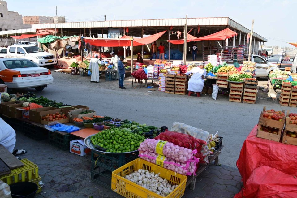
Outside the fish market area there was also a thriving trade in non-fish items. Across the road was the area where the fish are brought in, by fishermen on small boats. Sadly there was no action to photograph, but Rashid explained a little bit of the way the system works. People on the quay buy the catch off incoming fishermen and then sell it on to other people who operate in the market. Sometimes these people sell the fish direct, but often they split the catch and sell different parts either to different traders, or to people who further prepare (e.g. fillet or salt-preserve) the fish before selling it on. Complex and multi-level, but lots of opportunities for individuals to make their cut. I couldn’t make head or tail of it and couldn’t see money changing hands; but it clearly works.
Fish market duly visited, we were off again towards the next destination. We considered the idea of buying me some trainers or some such, but then decided that the shoes I was wearing (M&S finest Nubuck) would probably be OK. All that self-cursing was wasted emotional energy. Like it almost always is.
As we left the Muscat area, the terrain changed quite abruptly, and it was clear that we were heading towards the mountains.

So, via a stop to buy some snacks, we headed towards our next destination, en route to which we got our first initiation into what many of the roads in Oman are like.


Rashid parked up some way along the track at the start of something he called “Snake Gorge” (heaven knows what it is in Arabic), and we got out to take a look.

This was, had I known it, the first test of my footwear choice. I thought we had merely stopped for a photo opportunity, but no, this was going to be a bit of a hike, including wading through shin-deep water. So, while I think I would have been happier leaping from rock to rock in boots, I would still have gone barefoot for the wading bit.
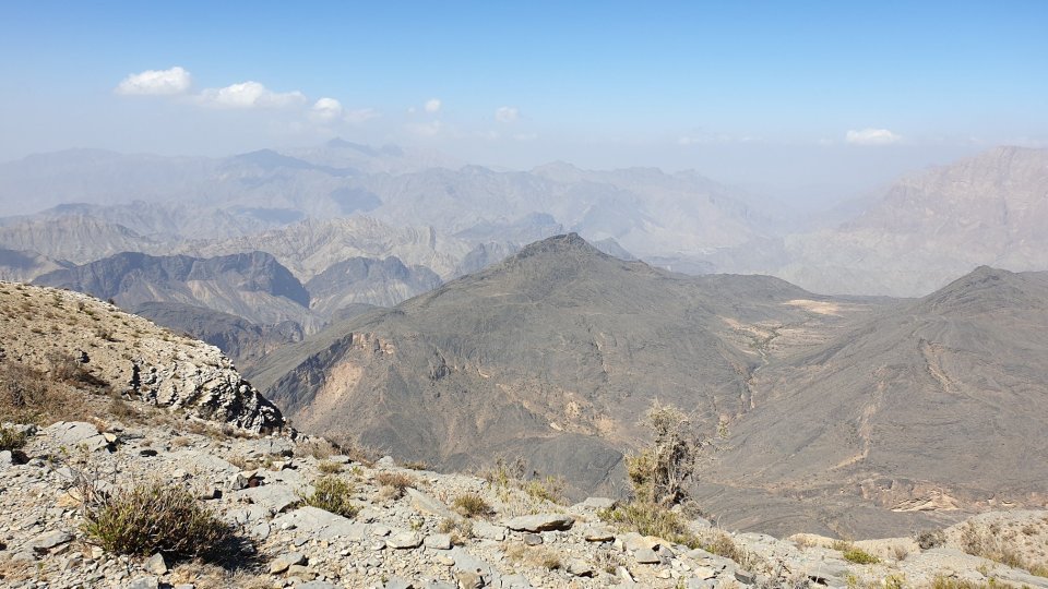
I’m not quite sure how to describe Omani mountain scenery. It demands to be photographed, but it’s a bit stark to be what I’d call “picturesque”. Here are some snaps from our hike.


The water, Rashid told us, was from rain which had fallen a couple of weeks earlier. So it was somewhat surprising to see small fish in the pools left after the bulk of the rainwater had cleared, and even toads, who were making the most of their time together.

It’s not clear how they got there – perhaps washed down from further up in the mountains? We also saw a rather striking red dragonfly

whose pose also gave a chance for a close-up of the striated rock prevalent on our route.
The rest of the day was spent travelling towards our camp, which was near the top of a mountain called Jabal Shams (“Sun Mountain”). We stopped off for some opportunities to see the stunning views that can be found in the Omani mountains:


(above is a view of a village called Al Hajir. I hereby apologise to the residents if I have the spelling wrong.)


In the photo above, if you look carefully you can see a tiny patch of green by the road going down the middle of the shot. This turns out to be a small but perfectly-formed artificial grass football pitch, called “Peter’s Pitch”.

It was apparently set up there for a film shoot and was left there afterwards. Peter, Rashid told us, was an itinerant occidental who provided funds so that the pitch could be kept there for the locals to use.
The mountain scenery during our journey was remarkable. Here’s a typical panorama:

And even our lunch stop, at a place called Al Sharaf, had a pretty nifty view.
After lunch we stopped in a village called Al-Hamra. Yes, it’s the same derivation as that of the famous palace complex in Spain. Hamra means red, and that comes from the distinctive colour of the mud used in the original buildings, seen here from across the valley. It dries to the shade of brown you see here.

In the foreground is the town’s plantation of date palms. Date palms are incredibly important to the Omanis. Not only do they provide dates (duh!), but the trunks, sawn lengthwise, can be used for roof beams; the leaves can be used in buildings as shade for the upper floors. The leaves are fibrous and can be dried to provide all sorts of fencing and screening; leaf fibres woven into mats and baskets; and the central stalks of the leaves are strong enough to be used in roofing (see later for our short visit to a bedouin home).
The old village itself has plenty of original buildings

and the town, in common with many in the area, has a watch tower

which in days gone by provided a vantage point to watch for invaders from nearby Nizwa, which was wont to send out raiding parties for food and females when they ran short themselves.
We also stopped to take a look at parts of a river called Wadi Ghul and the now-abandoned village on its banks

You can see the sweep of the original from the ruins of the fort on the hill to the left, to the village buildings on the right. Notice that the date palm plantation and other irrigated plantations, are still intact, and maintained by the modern day village from which this photo was taken. Oman is a very dry country and considerable care and ingenuity goes into preserving what rain falls and using it for irrigation (desalination plants are also an important part of providing water to the Oman population).
Then, as we were heading towards sunset, we approached our camp. It was first visible from across the valley

It’s there, honest – towards the top of the hill on the right…

yes, there…

…ah, there it is. We bumped our way along a very rudimentary track and caught sight of it again.

Our tents are in the background; this side of them are the tents for the crew who would support us for our two-day stay. We were greeted by Patrick, the camp manager, who then showed us round our facilities: our bedroom tent

with its bathroom tent behind and to the left; and the majlis tent, where we could relax.

It was getting quite late by that stage, so there was nothing for it but to crack open the gin (bought at Oman Airport duty free) and make the most of what sunshine there was before the temperature dropped.
Which it did, like a stone, with the chill exacerbated by a pretty stiff breeze. This weather somewhat informed my initial assessment of the practice of camping (I have put my thoughts about camping on a separate medium as I try to keep the language on this blog fairly moderate).
Before long we were eating a superb dinner lit by fire- and candlelight, sitting in front of the majlis.

but gradually becoming colder and colder, despite the fire. So we retired as soon as decently possible to a very comfortable bed, made even more welcoming by the presence of a hot water bottle for each of us. We did eventually get warm, but sleep was rendered elusive by (a) the wind, which was very noisy, both in itself and by making the tent creak and flap and (b) the knowledge that we had to get up at 5am to wring the most out of our experiences the next day. I thought this was supposed to be a bloody holiday!
Anyway, warmth and sleep eventually arrived and so we passed the night in reasonable comfort. To find out what happened on day 2, you’ll have to read the next entry, won’t you? See you there!


