Thursday 1 September 2022 – Our last day in Vancouver dawned bright and sunny, with the prospect of the weather staying that way all day. Guess how we spent most of it? Yup – we went for a walk. The obvious area for us to explore, because we’d gone in most other directions, was northwards to Stanley Park. Exploring there fitted our schedule which had to include a couple of other items, one tedious but necessary and the other much more appealing. We had to be back by about 4pm, so that allowed us our usual latish breakfast before we set out – no mad dogs, but two English folk going out in the midday sun.
Our route gave me the opportunity to try a second time at photographing a couple of scenes. The first was the “Cauldron”, created for the 2010 Winter Olympics here. This time it wasn’t beset by hordes of people dressed in white.

Nearby was something we hadn’t spotted before – a highly pixellated statue of an Orca.

As we walked towards the park, we were overtaken by a paddle steamer (or “sternwheeler” as they call them in these here parts)

and we walked along the pleasant pedestrian trail, nicely segregated from hordes of people shooting by on various wheeled contraptions, through the gentrified Coal harbour, near which is another interesting architectural exhibit.

As well as trees and general greenery, of which there’s a thousand acres overall, there are many items of interest in the park. Statues abound:

Robbie Burns, for no particular reason beyond the fact that he was famous, but I suppose the justification could be verse;

Harry Jerome, BC Athlete of the Century 1871 – 1971, holder of several world records, including 10.0 seconds for the 100 metres (1960); and

Lord Stanley,16th Earl of Derby, after whom the park is named.
There’s a miniature railway, which is jolly cute

and of which I had formed a mental image as having a steam train pulling the carriages. However
I was disabused of that notion. It’s still cute, but would be really something if they could actually manage a steam engine.
We’d been walking for about an hour by this stage in temperatures which were officially in the low 20s but which, in the full sunshine, felt a lot higher. So when we passed the rose garden

and its inviting pavilion

the prospect of a coffee or similar became very attractive. The staff seemed a little taken aback by having actual customers, but eventually things got into gear and we got decent coffee, and I had a beer to replace the electrolytes lost thus far on such a hot day.
Our wanderings then led us to the banks of Beaver Lake. At first it was challenging to believe that it was actually a lake

But it was, really.

We then headed towards the trail that leads round the edge of the park, as we wanted to see the Lions Gate Bridge, the large suspension bridge that crosses Vancouver Harbour to the north. Or south, if you’re coming back. It’s very impressive

but kind of difficult to convey photographically. We spent some time trying to do this and, basically, failing, so turned back to walk the waterside trail hotelwards. This took us past a small beach

and towards some further curiosities: a lumberman’s arch;

a kids’ splashpark;

a replica figurehead of the SS Empress of Japan, which took cargo to and from the orient around the turn of the 20th century –

presumably worth displaying because figureheads went out of fashion pretty sharply once steam ships, erm, took off; and a statue called “Girl In A Wetsuit”

Though initially Gull In A Wetsuit seemed more appropriate. Eventually the annoying bird left and I could get a proper version

and we carried on round the edge of the park. There’s never a dull moment: totem poles;


a splendid view of the sulphur processing facility on the opposite shore of the harbour (it’s from Alberta, apparently – the sulphur, that is, not the machinery);

the Nine O’Clock Gun

with its warning
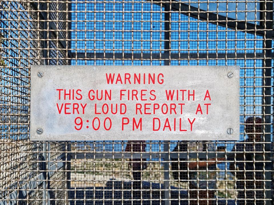
(which is helpful, but goes nowhere near explaining why there’s a loud bang every night); evidence that the segregated walking/cycling trail had its roots well before cycling became cool;

And even – gasp! – some wildlife.


Heron and harbour seal respectively and unconcernedly fishing and sunbathing (upside-down) as city life went on around them.
We’d walked a fair bit, but it’s clear from the map of our ramblings that we’d left a lot of the park unexplored,

Maybe we’ll be able to get back in some future life and explore further….
As you leave the park, there’s the very impressive HQ of the Vancouver Rowing Club

and then you join the trail leading back into Vancouver city. This gave me an opportunity to get some nice photos of my favourite type: reflections,

including a second attempt at one I tried on our previous visit;

I’m a bit happier with this version.
This brought us back to the city and the first, tedious, one of the two things we had to achieve – checking in for the Rocky Mountaineer, which will be our home for the next couple of days as we start Part Two. Our advance party (otherwise known as brother Chris, who has been about a month ahead of us on his version of a Canadian odyssey) had reported scenes of queues, chaos and confusion at the Pan Pacific Hotel, where a check-in facility had been set up. So we went in to scout out the scene. What we found was just a genteel and well-behaved (but quite long) queue,

So, since I know my place, I did my job as queue placeholder whilst Jane nipped back to the room for the paperwork. Over about half an hour we slowly edged forward and eventually reached the front. Because Jane is superbly well-organised, there was no call for chaos, or indeed confusion; we had all the right paperwork to hand, had checked in online and had our boarding passes; and so very swiftly got our baggage tags and instructions. These included being ready to leave our hotel at 0650 the next day, unfortunately, but, hey, that’s the price we pay for being on holiday.
That then (preparatory packing aside) left the way clear for the second, happily anticipated task, which was to meet the Delightful Danes, Philina and Søren, whose company we’d enjoyed so much in Farewell Harbour. Philina got in touch via this very blog and we established that we overlapped for one evening in Vancouver, so we went to meet them at a local eatery called Riley’s and had a very fine time. They had also had great luck with the wildlife at the lodge – fishing bears and breaching humpbacks, for example – and had visited a couple of wonderful sounding places. It was lovely to catch up with them, and I hope we will get a chance to meet them again some time in the future.
Then all we had to do was to set the alarm for 0530 in preparation for the start of Part Two – The Rocky Mountain Bit. Be assured that whenever I can get time and internet access I will report back, so please keep an eye out for the next thrilling installment.


 Aquabus (Latin) – to, for, by with or from water.