Tag Archives: canyon

A scramble in Isalo National Park

Saturday 15 June 2024 – Le Jardin du Roy is very nicely put together. The rooms are spacious and comfortable; my main gripe is that there’s not enough light to see what you’re doing.  I suppose that this is a consequence of running from solar power and/or a generator, but it makes finding things (e.g. a black laptop on a dark surface in an underlit room) very frustrating. The internet availability was pretty poor, too, but the food was good and the service very agreeable.

Its buildings were in very lovely stonework,

and whoever designed or crafted it put several “hidden” things among the stones. At a basic level, you could find things like this star among the stones.

but there were more complicated creations as well.

Two lemurs and a palm tree

A nativity scene in our room

The day dawned, as I imagine is a regular pattern at this time of year (beginning of the Malagasy winter), cool and misty.

Our mission for the day was to explore Isalo National Park, so we headed to town (Ranohira) and Kenny (a) introduced us to our guide, José and (b) got tickets for the National Park , which, at 815 square kilometres, is pretty substantial. It was created in 1962, and is mainly dry, deciduous forest, based on sandstone landscapes, which means there has been plenty of erosion from wind and rain, creating rocky outcrops, plateaux and canyons up to 200m deep.

Our main objective for the day was to walk along one of these canyons.

After a short drive, we started our hike, for it definitely wasn’t a walk in the park, as you’ll see as you read further.

The scenery was quite spectacular with the sandstone cliffs we’d seen elsewhere.


We were headed alongside a river, as one could tell from the aquatic bamboo plants we could see.

The path started off easy enough

and, as happens so often, we started off with José explaining all sorts of non-wildlife stuff, such as: the difference between young Pandanus palms (single stem, thicker leaves, in the foreground) and older Pandanus (branched, leaves thinner, in middle and background);

and the iron pipe leading water to the town, some 6km away.

We did see some of the local fauna:

Darwin’s Bark Spider and its web

Madagascan White-Eye

I was dead chuffed to have nailed the image above, as the birds that we occasionally saw around us were exceedingly skillful at detecting the instant before a camera shutter is pressed and buggering off.

We soon reached a picnic area

where some lads were starting the preparation of a cooked lunch (what is it with men and outdoor cooking?) for those who had booked it (we’d chickened out, or rather cheesed out, and ordered a packed lunch to protect our, but particularly my, digestive systems). Here, we saw a Red-fronted Brown Lemur

who was very cute, but actually had a very sad back story.  She had got separated from her family group during a bush fire, and had failed to find them again; so she was lost and solitary. She hung around the picnic area trying to steal food – of course everyone was told not to feed her – and she must have been very lonely.

José also found us a White-browed Owl

but the real excitement was seeing a Ground Boa crossing the trail just in front of us.

We stayed very still, hardly daring to breathe, so that it carried on its way into the forest. It was about a metre and a half long.

The walk continued alongside the river into the canyon, which was the main objective of the day’s hike.

and we were treated to a succession of great views as we scrambled over the rocks (it was a real scramble in places,

and we were both grateful for the sticks we’d brought with us from Ranomafana).

Some of the trail had been prepared to make it easier for the punters

and José told us about what happens during the rainy season, when the water level rises several metres.  Some evidence of this could be seen in the trees that had been deposited among the boulders in the canyon.

We eventually reached a couple of pools: the Blue Pool

and the Black Pool (which had no illuminations)

where the trail basically ended.  So we took a rest while Jose and Kenny shot the breeze

and then headed back the way we came. There were a couple of encounters with the local fauna:

Dragonfly

Water beetles

And the colours of the stone were fascinating.

When we got back to the picnic area, we were lucky enough to see a group of Verreaux’s Sifakas.

They were very athletic, as ever, leaping from bough to bough, rather better than the Monty Python sheep, who, of course, tended not so much to fly as to plummet.

After our packed lunch, eaten amid the haunting scent of delicious food being cooked for the other picnickers,

we headed back to the car.  On the way, we passed a rock on which was perched what I heard Jose describe as a “snot bug”.  Eventually, we understood it was a Snout Bug, for fairly obvious reasons

though I suppose that if it caught a cold, then maybe Jose’s original description might have been the better one. We also saw (among the other, more orangey coloured ones) a butterfly with a beautiful blue hue.

That was it for the hike; the canyon was a lovely, if slightly tense, experience, and I was glad to have caught some video of the sifakas.

On the way back to the hotel, we passed a couple of very colourful local scenes.

We had an evening entertainment laid on – a short walk to watch the sunset. On the way, we were lucky enough to see a Hoopoe,

though I had the wrong lens on the camera for a truly good shot. It was still nice to see it. The hotel had laid on a resting place for us (which we laid on)

and a cocktail service

(with nibbles).  The scenery was striking in the setting sun

and the sunset itself was not bad,

(middle photo from a mobile phone; outer two from my Big Camera; shows that mobile phone cameras these days are pretty damn’good).

Actually, we got more striking colours looking behind us

but it was a nice way to finish off the day. The nibbles had been enough food for us, so we simply retired to our room and took no dinner. Since we were (we were told) the only residents at the hotel for that night, it must have meant an entire kitchen staff on duty for no purpose; but we’re at the start of the tourist season, so I guess the hotel must expect quiet times.

We leave the hotel tomorrow, rather early, as we continue our south-westerly journey to Toliara, on the coast.  We have a Thing To Do en route, which we hope will be interesting.  I’ll of course report, so please stick with these pages to find out what we got up to.

Jasper, Much Maligne’d

Saturday 10 September 2022 – In declaring yesterday’s rest day to be the End of Part II of our grand odyssey, it turns out I was a bit previous; we still had a little bit of Rocky Mountain-style business (i.e. lakes, waterfalls, that kind of thing) to attend to. Also, since we had failed to visit Jasper, we thought we should at least go in and see what was the state of affairs there.

Accordingly, we set out towards Jasper. As we drove the short distance in, we saw something a little out of the ordinary:

a helicopter carrying a bucket. There was no smoke visible, but we guessed that this was attending to some wildfire business or other – see later. We also saw a temporary roadside sign on the highway which said “Power out In Jasper. Do Not Stop”, but we ignored that.

We went in to the town, wondering whether there was any power to any of the infrastructure. Having parked the car, we discovered that at least the parking meters had power – of course they bloody would – and spent a few minutes negotiating with one. It looked like we’d chosen the station car park.

There were plenty of cars parked in the car park, but the roads were very quiet for a Saturday morning.

Some of the shops seemed to have the lights on, so we popped in to one of them, a tourist gift-type shop, and pretended to look as if we were going to buy something in order to ask the shopkeeper for his assessment of the situation. He said that most businesses now had their own generators and were open, with the main exception being some hotels and restaurants, which had not re-opened; we made a mental note of this to update Brendan later.

Jasper is an attractive place;

the downtown has some nice buildings and some street art on display, too.

It did seem that many businesses were operational, but there was a variety of generator solutions on display and a pervasive hum

and not every business was open.

However, there were a few people about in the attractive downtown area.

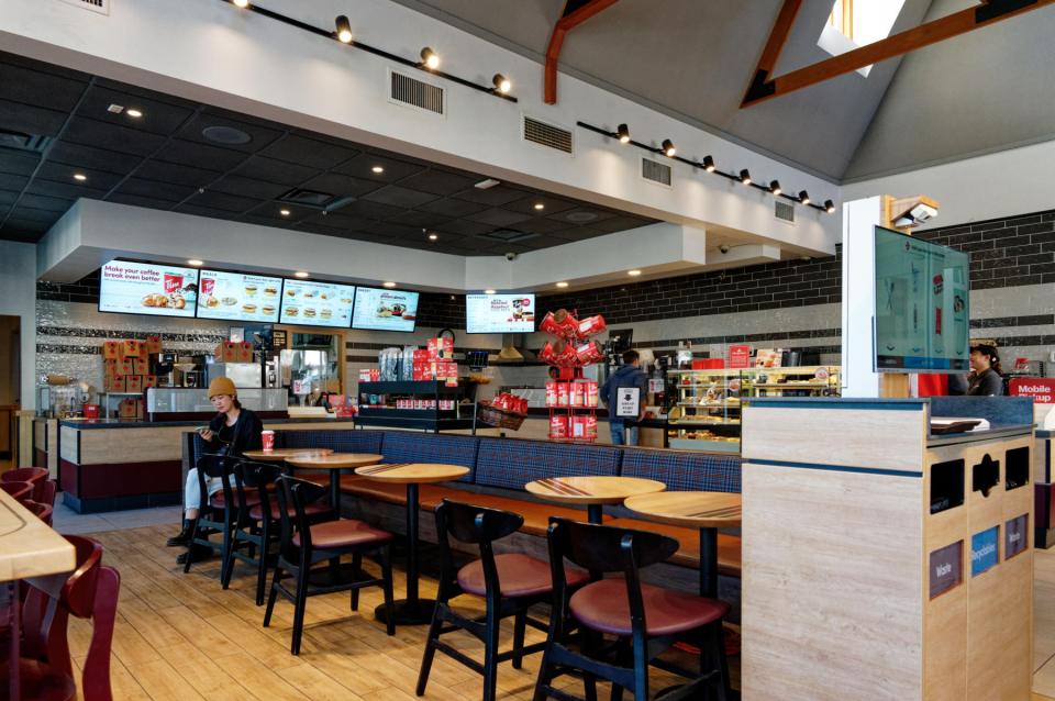
Seeing the Tim Hortons, a Canadian coffee shop chain, we thought we’d try out the experience.

It’s a perfectly decent way of getting a coffee (and any manner of cake), but is workmanlike rather than classy. Whilst we were there, we did see evidence that there really was a town shuttle bus,

despite its non-appearance the previous day. Having reassured ourselves that Jasper was gradually getting back into the swing, we headed back to the car, past a streetcar that was handsome, but looked somewhere between faded and disused.

(We saw it in operation later in the day, so it’s not disused, at any rate.)

Right: onward to the last bit of Rocky Mountain stuff, then. There’s a road out of Jasper which leads past two lakes, Medicine Lake and Maligne Lake; both of which are fed by the Maligne River, which in turn feeds into the Athabasca River. Going along this road brings you first, though, to Maligne Canyon, which was therefore our first stop. As you drive the road towards it, there are signs off to “Sixth Bridge” and “Fifth Bridge”, and this starts to make sense once you see the trail map in the canyon car park,

although not much sense; it has to be said that this trail map is somewhat confusing. We saw a signpost to “Second Bridge”, so we thought we’d better start somewhere. We walked from Second Bridge to Fourth (which did need repainting, actually) and back, and then, because it would have taken too much time to go further, back up to First.

We covered a couple of miles, which was much more than I’d expected – I’d thought it would be something like the Mistaya Falls we’d seen on our Icefield Parkway drive. The idea was the same – a torturously twisted canyon carved out by a fast river – but this was much bigger. I’ve tried to condense the trail from start to Fourth Bridge in a video:

it’s an engaging hike, unsurprisingly quite popular.

Next up: Medicine Lake. As we approached, we passed an area which had clearly been affected by wildfires.

Medicine Lake has a viewpoint at its north end

and close examination of everything on the right bank from that viewpoint showed that it had been severely burnt and fairly recently, as there was little evidence of regrowth. Looking back up the lake from the other end

showed that there had been some fire damage to the other bank, too.

We pressed on to Maligne lake, and it became clear that things were, erm, not clear; the visibility was very poor, and we assume that this is because of smoke from the fire that has affected Jasper so badly.

When visibility is good, Maligne Lake looks to be a wonderful place to visit – see my brother Chris’s blog post that includes their visit here – but there was nothing really to see here, and time was beginning to press, so we headed back to the main road that would take us to Edmonton, our next stop. We spotted the same bald eagle’s nest that Chris had

and also some roadside wildlife in the form of bighorn sheep which were wandering about, eating some of the scenery.

That really did conclude the Rocky Mountain section of our holiday. As we motored on towards Edmonton, the scenery changed. Interestingly, though, there was still the danger of wildfires and smoke – signs by the roadside warned of the possibility; and we even saw a wildfire in progress in the distance

and the knock-on effects of the smoke.

Soon, though, the scenery flattened out and we just motored on relatively flat roads towards Edmonton. The main interest in the drive for me was my gaming the Lane Assist function available on our rental car so that it didn’t realise I only had two fingers on the steering wheel, and trying to move into the overtaking lane before the adaptive cruise control slowed us down. I know how to have fun at the wheel of a car.

There were a couple of possible digressions on the route, but we ended up diverting only to one of them, the intriguingly-named “Beaver Boardwalk” in Hinton. It actually does what it says on the tin; there’s boardwalk and it leads past the evidence of beavers, erm, beavering: a dam;

and a lodge (we think).

The place is quite a nice diversion

but it seems that it needs some TLC – some of the boardwalks were closed, and others needed some attention. It borders on other terrain in the Maxwell Lake area, and this is obviously a place where people can walk and bike around, and where there is significant wildlife. I found it amusing that somewhere that tells you what to do when attacked by a cougar

or a bear

could, erm, bear this name:

So, refuelling aside, our next stop was to be Edmonton. We were a bit disconcerted to see this sign

as we thought we’d left Jasper far behind.*

In Edmonton, we encountered a slight issue that one doesn’t come across so much whilst driving in the UK these days.

Despite these slight visibility problems, and with help from the satnav, we found our hotel, the impressive edifice that is the Fairmont Macdonald (pictures tomorrow). It was past 7pm by this stage and so we forsook any actual unpacking or such domestic admin to head straight down to the restaurant which featured a patio. This was lovely.

We were expertly served by Tyler, who was clearly a seasoned campaigner (emphasis on the “camp”, but assured, courteous and expert), after which we tried for some after-dark photos in the hotel’s garden.

— GEEKY PHOTO ALERT —

The hotel has a nice view over a suspension bridge which is illuminated. There was a low, full moon of a beautifully muted hue, which I tried to capture on both my mobile phone and my Big Camera. The difference between the two is striking:

The top was my mobile phone, the bottom the Nikon. The mobile phone photo is a nicer scene, although it’s much noisier; but unless you need a technically high quality image, the mobile won this round.

— END OF GEEKY BIT —

That was it for the day. We have nothing planned for the morrow, so wandering about will be the order of the day. Come back and see what we found, won’t you?

* English comedian reference. Sorry.

Day 12 – Yes, We Canyon!

Saturday 10th July 2021. One loses track of time on an excursion such as ours. It was something of a jolt to realise that it was the weekend, at least for everyone else; we just carried on in our little dream world as we explored the southern region of Iceland before joining the “Golden Circle” route tomorrow. And, probably, hordes of bloody tourists.  We’re now within range of day trips from Reykjavik, and it showed in the number of punters and the number of coaches at the various places we stopped for a gawp.

The first of these was yet another Interesting Church, this one on the site of a medieval convent at Kirkjubæjarklaustur, very near our hotel.

Like almost every Interesting Church we’ve come across, it was closed, and I have yet to hear a credible explanation of how come there are all these churches which seem almost universally to be unused on any kind of a regular basis.  Is there a vicar or priest? Is that person a visiting official? Who pays for the upkeep? etc, etc. Anyway, it’s lovely to see such interesting church designs; and this one is not the last of this trip.

The next place we went to has to be one of the most arresting sights of our holiday in Iceland. It’s called Fjaðrárgljúfur and is billed as a canyon.  As you approach it, you begin to get some idea of what awaits.

Then you look carefully and you can just make out a couple of sheep as the merest dots (just left of centre in this picture)

and then you climb to the observation platform and see this

This was the first Shot Of The Day. It is a truly awesome sight, without being completely overwhelming (like, say, the Grand Canyon is).  A remarkable start to our day. You can walk down towards the other end, passing some sheep

(one was sleeping and we hope it didn’t really drop off) and have a look from there.

There’s a figure on the right bank as we look along it from here, and that gives some idea of scale.

We next got a chance to see a couple of uniquely Icelandic things.  The first was a sheep rounding circle.

There are half a million sheep in Iceland – more than the number of resident people – and they are basically free to roam.  This means that you can come across them almost anywhere, sometimes, alarmingly, in the middle of the road as you drive along.  Somehow (by horse, dog, 4×4, anything that works), every September these wandering sheep are rounded up from wherever they’ve got to, a convulsive effort over around three days which is a massive part of Iceland’s culture and something that all farmers have to join in on.  The sheep are herded into the central pen and then individual farmers pick out their sheep (they all have ear markings) and separate them into that farmer’s segment.

The second insight came as we got a chance to try to grasp the impact of an enormous event in Iceland’s – and indeed the world’s – history – the Laki Eruption of 1783-5.  This was of staggering size and impact: an outpouring of an estimated 42 billion tons or 14 km3 (3.4 cu mi) of basalt lava and clouds of poisonous hydrofluoric acid and sulfur dioxide compounds that contaminated the soil, leading to the death of over 50% of Iceland’s livestock population, and the destruction of the vast majority of all crops. This led to a famine which then killed approximately 25% of the island’s human population. The lava flows also destroyed 20 villages. The eruption and its aftermath caused a drop in global temperatures, as 120 million tons of sulfur dioxide was spewed into the Northern Hemisphere. This caused crop failures in Europe and may have caused droughts in North Africa and India.

We stopped in the middle of the huge lava field resulting from this eruption.  It’s difficult to convey the scale of it – kilometre after kilometre of moss-covered lava, because only moss – nothing else – will grow on lava, and this takes centuries to develop.

I created a Facebook 3D photo which might help to underline the scale of this.

Our next port of call was what Dagur called the “Yoda Cave” – actually used as the setting at the star of Star Wars – Rogue One, as the cave our heroine dashes into to escape from some band  or other of marauding riffs.

It looks quite impressive from the inside as well.

This is in a part of Iceland that used to be an island, but the volcanic actions raised the land up around it.

This is close to a town called Vik, which has an Interesting Church, more for its location than its architecture.

In the distance to the left can be seen the “Three Trolls”, Reynisdrangar, rocky outcrops off the beach, Reynisfjara. You can get a closer view of them from Vik’s black sand beach.

We headed over towards them and I guess this was the first time we came across hordes of tourists – Reynisfjara is a popular spot and the car park was crowded. There are a couple of lava caves

one of which has basalt columns by it – popular for kids to climb on.

We carried on along the coast a short way, stopping at the clifftop at Dyrhólaey, which has a view over an impressive rock arch

as well as the surrounding countryside

it’s own troll

and – delightfully –

puffins!  Dagur explained that these are often blown over from their usual colony to the east during August.  The fact that some are here at this time of year, and that they appear to have burrows that they are using, implies that this is becoming an established puffin colony in its own right.  I took loads of pics, obvs, and even nearly managed an in-focus one of a puffin flying off.

But the wind was gale force and so hanging about to try to get a better photo was not a comfortable option. We moved on.

The southern region is marked out, as I posted yesterday, by glaciers and the road to our next major stop offered a chance to get a nice picture of one of them – an offshoot of Vatnajökull, but I don’t know which one, I’m afraid.

The rest of the day was almost exclusively about waterfalls, which was a relief.  It’s been ages since we saw a decent waterfall and I was beginning to get withdrawal symptoms.  Our next stop, then, was at Skógafoss, but we were hungry so stopped for lunch at the hotel there before exploring the waterfall itself.

And it’s a splendid sight.  The car park was crowded, as was the shoreline, with lots of people getting in each other’s way as everyone tried to get fucking selfies, which always enrages me. Mind you, I did manage to get something out of other people’s cavorting.

By aggressive use of sharp elbows, I got to the front where I had a few seconds to get a view of the falls unsullied by tourist vapidity. But actually, the second Shot Of The Day came about as a girl walked in even further through the spray towards the falls and gifted me with the perfect shot.

Before the next waterfall, we stopped briefly to view some turf houses in a place called Drangshlíð.

I found this post about them on the web, but it didn’t really leave me any the wiser.

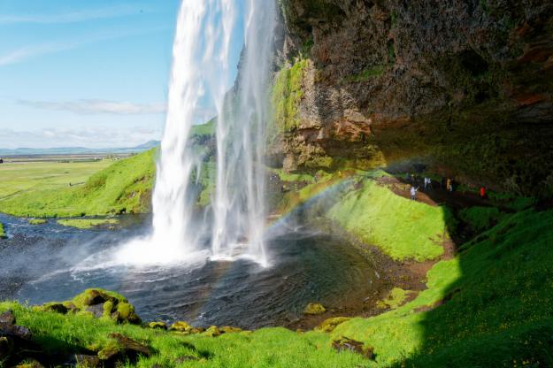
A few kilometres along the road we stopped at Seljalandsfoss, which is another great sight.

It’s very popular, as it’s a waterfall you can actually walk behind

after having done which, you can walk along to another one, called Gljufrabui.


View this post on Instagram


A post shared by Steve Walker (@spwalker2016)


And that was nearly it for the day’s interesting bits.  We are staying the night in the Sel Guesthouse near Skalholt, and it is a charming place.  Though the charm is somewhat rustic, it has WiFi and other mod cons, geothermal hot water in the bathroom, but no restaurant.  So we made our way to the Farmhotel Efstidalur, which really is a working farm.  From the cafe, you can see the cows

and upstairs in the restaurant you can eat them.  We had a pulled beef salad which was absolutely delicious.  Then we indulged ourselves with some of their home-made ice cream downstairs.

Thus ended our day. We will be Doing The Golden Circle tomorrow, with the major tourist sites and sights that this offers. It should be a good day, and it’s our last day on this tour, so let’s hope for a final Grand Day Out. Please check in tomorrow to see what actually happened, why don’t you?