Cami-flage Day 6 – Wednesday 16th September 2020
Once again, the major difference in weather between Surrey and Menorca was simply a 6-degree difference in temperature, with both otherwise having the prospect of a sunny day. Frankly, walking in 24°C is a nicer prospect than 30°C, so I feel we’re on the plus side of the equation at the moment.
Here’s the outline of today’s walk, which was around the Royal Estate of Windsor Great Park. The Queen is not in at the Castle today, hence the title of this post.

As you can see, because you’ve been paying attention, haven’t you, this is in very much the same neck of the woods as yesterday’s walk, though we tried to minimise overlap.
We started from the Saville Gardens, which has a recently rebuilt and good-looking visitor centre (and shop, of course!)

and headed north into the Great Park, stopping at Cow Pond for a photo.

A pair of Egyptian Geese were fossicking around among the water lilies.

There’s a very photogenic bridge at the top end of the pond

which seemed a perfect opportunity for the first shot of gin for today.

Moving further north into the park (note to readers – don’t bother to try to find a short cut out through the rhododendrons at the top end of the pond, just be sensible and go back to where you came in. You’re welcome) brings you to Bishopsgate, one of the main entrances to the park, near the Royal Lodge, a set of official buildings in the park’s rather fetching Official Pink colour

and the path then heads out across the park in a westerly direction. We noted some more fine fungi, it being that time of year

and eventually arrived at the classic view of Windsor Castle, down the two miles of the Long Walk.

It seemed a good idea to exploit this for a second gin bottle shot.

(Interestingly, bicycles are not currently allowed into this part of the park, although they have been permitted at other times. It’s a deer sanctuary and I wonder if that’s got something to do with it).
As you look at the castle, behind you is the statue of George III,

and over to the side of it is a wooded area, where we found some of the deer; this is a group of the adolescent males, hangin’ out and chillin’ until one of them can take on Sir who’s busy looking after all the lady deer in another part of the park.

To enter or leave the deer park involves going through some fairly imposing gates. I rather like the consideration given to horse riding in the park – on the right hand side of the road is a release button on a post, at shoulder height for a rider, making it easy to press to open the gates for entry and exit.

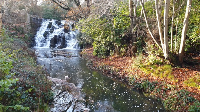
Moving on westwards, as you head for the edge of the park, you come across The Village, which has sinister overtones for anyone who remembers The Prisoner but in every other way is a pleasant collection of buildings which house people and businesses to do with running the park and the Crown Estates – that’s all the bits of the country owned by the Queen.

It has an attractive pond

and, among other things, a Weeping Birch, which appears to be about to leap upon passing tourists.

The village green is also very picturesque

but, more to the point, also features a post office and village shop.

Which sells ice creams. Which it would be rude not to sample, wouldn’t it?
Also around there is another pond, with a wonderful weeping willow

and further reminders that Autumn is on its way.

Turning left brings you to Sandpit Gate, which has a gatehouse in the Official Pink colour.

It also has buildings in a part labelled as a Private Area. If there were any doubt what this actually meant, a chap in an official-looking Land Rover stopped by us as we looked in and made throat-slitting gestures, so we moved on after taking a couple of snaps.

The road then took us past Queen’s Ride, which offers a long look down towards the Castle

and is overseen by a statue of Her Maj which dates from her Golden Jubilee: 50 years on the throne in 2002, which gives a good idea of her famous dedication to duty.

I had planned a route going thence past Great Meadow Pond, as the map seemed to tell us that there were paths leading that way, and it’s a part of the Park that I’ve never visited. The reason for this became clear as we looked for the route: it would actually take us into another Private Area, so we thought we’d be good citizens and headed back to Duke’s Lane, which is a road leading South and back towards Virginia Water Lake. It’s pleasant enough, particularly on the sort of nice sunny day we had, but is long and somewhat short of variety. There was some excitement as we spotted a tree being held up by guy ropes, for example, which shows you how little there is to feast one’s eyes upon.

After a mile or so of Duke’s Lane, one can dive off left along a track, which is actually a good idea for people on foot; the alternative is to exit the park and then have a very unrewarding mile or so along a main road with no footpath. However, the track, which is intended mainly for horse riders to disport themselves along, is also long and somewhat short of variety.

although there was one fine fungus to be seen.

It transpired that having to go along the last half of this track was an error; officer i/c navigation (that would be me, then) wasn’t paying attention and we should have left the riding track and walked along the side of Virginia Water Lake at one point. However, we weren’t tempted to go back and find the right track because we were (a) headed in basically the right direction and (b) imminently due to arrive at the Blacknest Gate exit of the Park in order to have a Nice Lunch, which, having walked 7½ miles at this point, we felt we deserved. And we duly got it at this splendid restaurant.

Bluebells was once in Sunningdale and we thought it had shut down; it turns out that it had moved, and it is every bit as good in its new location as it had been. Thoroughly recommended.
After lunch, we tottered back into the Park, passing some lovely hydrangeas

on the way towards Smith’s Lawn, which is a vast area of beautifully-maintained turf whose main purpose is to support the playing of Polo; the Guards Club runs the matches there.


Our luck was in – there was some Polo being played! So we watched for a bit (without actually understanding what was going on, but being impressed by the horsemanship and the thundering of hooves)

and I used it as the excuse for another gin bottle shot.

The final leg of the journey was to circumambulate the Obelisk Pond, which is just south of the Saville Gardens. Using a route we have rarely walked before, we discovered a lovely scene of a bridge across the end of the pond

crossing which offered a good view of the eponymous obelisk,

and enabled a final gin bottle shot before getting back to the car. This bottle is a well-travelled entity.

So, we are nearly half way through the 13 days of walking. Today we covered 10.47 miles and so far we have walked over 50 miles, which is over three miles more than we would have covered by this stage had we been walking round Menorca. Tomorrow is going to be something of a test of our fitness and stamina as we take on an 11-mile walk that we have found quite challenging in the past. In theory, we are both lighter and fitter than we were when we last took it on; tune in tomorrow to see whether the practice matches up to the theory!