Tag Archives: Castle

Day 10 – San Quirico d’Orcia to Castiglione d’Orcia – short but sharp

Friday 23 May 2025 – Despite the short distance we had to walk today – 10km is the official distance – we still found ourselves up and ready to depart by 8am. I had looked at the profile of the walk offered by the S-cape app

and formed the opinion that it should be really quite easy, with only gentle ups and downs.

Wrongly, as it turned out. I should instead have looked at the representation offered by Garmin Connect for the same track,

which gives a far better impression of what the day will bring.

Anyhoo…

The breakfast arrangements for our B&B took the form of a voucher to be used at L’Officina del Gusto (The Office of Taste), which had interesting decor

but a limited selection of breakfasts: sweet or savoury. As we continued on our route, the weather looked a trifle ominous

and the various weather apps suggested that there was a real possibility of rain.  However, none materialised and the morning was cooler than we’d experienced before on this walk. We soon left the tarmac for a dirt road, with the usual offering of great scenery.

As we walked along, Jane and I agreed that the Via Francigena was better than the Camino Francés for scenery, but the Camino offered much better infrastructure, particularly rest stops. I guess if you want the scenery, you have to be prepared to walk up the hills.

We passed a few frog ponds,

which were all as noisy as the first one we’d seen a couple of days ago. It struck me that you don’t get that kind of racket in frog ponds in the UK, but I’m not an expert in country ways. Jane, however, has roots in the countryside and she agreed that frogs in the UK weren’t that noisy. Perhaps it’s because these are Italian frogs? We’ve noticed that Italians in groups and silence are to a large extent mutually exclusive.*

A large lump hove into view,

giving us the opportunity to disagree on exactly what it was. Jane thought it might be Radicofani, and I thought it might be Ripa d’Orcia. We were both well wrong, but we did find out eventually what it was. (That’s the bait to keep you reading, which is a bit pathetic, really, but this is the level to which I’ve sunk.)

We knew that there were a couple of interesting stops on the way, and we soon saw the first,

the roofs (rooves?) of Vignoni Alto, described as “one of the best-preserved fortified villages in Tuscany”. Our route led us through it, and it is indeed a very attractive place; we think it’s mainly holiday apartments to let.

Some of the apartments have a simply staggering view.

It was very quiet and therefore too good an opportunity for aerial photography to miss out on.

The road from there leads down

and down and down; it’s a dirt road, but one with signs for motorists warning them that it’s a dangerous slope. We were still fairly high on the road when we realised what the lump was.

It was Rocca di Tentennano (sometimes called Rocca di Castiglione); the reason we rumbled this was that it had been hiding Castiglione d’Orcia behind its bulk and we could now see that we were in for a bit of a climb to get to our destination for the day. However, before we could start the ascent, we had to complete the descent, which led past the other point of interest of the day – Bagno Vignoni, a thermal spa.

While it was always going to be interesting to see the baths, the main thing for me was the presence there of a coffee stop.

It was a popular stop and there were a many cyclists there as well as pellegrinos and a few posh-looking people in civvies – there’s an upmarket hotel attached to the spa. You can tell because the inevitable cypresses are manicured to within an inch of their lives.

It’s an attractive setting.

and we enjoyed looking around it almost as much as we enjoyed the coffee and (very good) filled croissants that were on offer.

The Via route after that continues down and has to cross a river at its lowest point. In theory, there’s a pedestrian bridge across it

but it’s closed; they really don’t want you to use it.

We therefore walked around the road and started the ascent. This is where I realised how much I had misread the profile diagram. Bits of it were really steep – 18.6° was the steepest I recorded, and that is 1 in 3. I hastily revised my decision not to use walking poles and we made our way up the slope (it wasn’t all up, but the bits that were up were quite hard going). Of course, the views improved as we ascended.

and we eventually reached Castiglione

which was very pretty

and very full of cyclists.

We found out that our visit had coincided with the Tuscany Trail; some 600 lunatics cyclists completing a 430km ride. I didn’t notice any e-bikes among them….

Castiglione d’Orcia, being a place with a long historical record (first noted in the year 714) has a street layout that doesn’t owe much to common sense, and a street numbering system to match.  Jane did a great job to actually find our B&B, Il Vecchietta, which, it being only about 1.30pm,

was, of course, closed. However, a phone call brought forth someone to let us in, and we were able to hose ourselves down before heading down to the restaurant, Il Cassero, whence the kind person with the keys had come to our aid. We had a Nice Lunch there; very Italian and very affably served. I continued the pasta experiment and will report on it in due course.

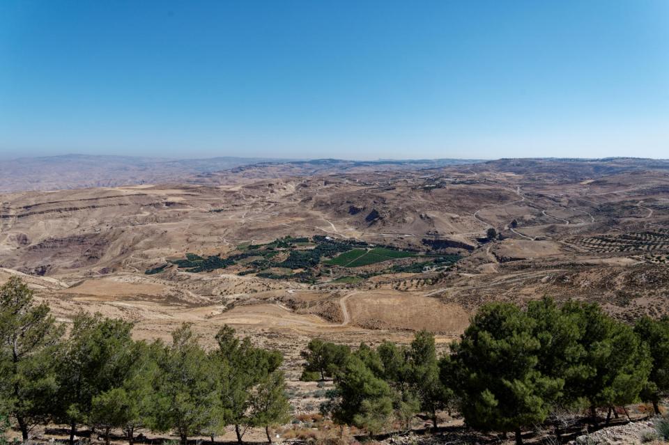
After lunch, we had some time before the local Coop opened and we could buy milk for any cups of tea we might plan, and so I took the opportunity to do some more aerial work.

Rocca del Tentennano, which is a fortress. Really, it is.

You can clearly see the castle that gives this place its name

The walk to and from the Coop gave us the chance for some more pictures of the place.

Like Horace Wimp’s girl, it’s small, but veeery pretty.

And so to tomorrow, where we are back to dealing with a long walk, towards Radicofani, which involves a fair bit of uphill work and several fords, so it’s likely to be interesting as well as testing. The arrangements are all very complicated, but All Will Be Revealed in the next post.


* Sorry to appear racist, but I couldn’t resist


Day 3 – We hit peak Mosaic

Tuesday 17 May 2022 – We had an early start today; once again, the only times we have to get up early is when we’re “relaxing” on holiday.  Anyway, come 8am, we were on the road that would lead us eventually to Petra, but which had several stops on the way.  Almost all of these stops seemed to involve mosaics, so I hope you like mosaics.

The first stop was in the town of Madaba, the “City of Mosaics”, to visit St. George’s, a Greek Orthodox church. The reason that so many people visit it is that it is the home of a very famous mosaic, the oldest surviving original cartographic depiction of the Holy Land, dating from the 6th century AD. The mosaic was rediscovered in 1884, during the construction of a new Greek Orthodox church, St. George’s, on the site of its ancient predecessor. Outside (and replicated on cards in the on-site retail opportunity) is a large display explaining what the remaining areas of the mosaic are.

The map mosaic itself is very difficult to convey photographically, because it is so large.  I took a couple of snaps, of course I did, but I also tried to give an idea via video.

It is amazing that there are still areas of the mosaic that are still hiding under tiling work that has been laid on top of it, for some bizarre reason.

As well as this historic ancient mosaic, the church has an incredible array of modern mosaics, made in the Madaba School of Mosaics (these days called the Madaba Institute for Mosaic Art and Restoration), which can be found on every available display surface.

They are very intricate and beautifully made.

On searching for the etymology of the word “mosaic”, I learned that it has its roots in the Latin for the Muses.  It’s also true that Mosaic (capital M) means “pertaining to Moses”, which is relevant for our next stop, which was at Mount Nebo, the site from which Moses was allowed to see the Promised Land, and where he then died. It is obviously a site of great historical and religious significance, but the Moses Memorial church there (originally built in the 4th century AD and restored by the Franciscans in 1932 to working monastery status) is quite a plain building, and not ornate at all.

Since this is where Moses could see the Holy Land, you might expect there to be a decent view.  You’d be right.

It’s a popular spot for people to look from, and marked by a representation of Moses’ staff.

On display outside the church are a couple of the mosaics from the original building

but it’s inside the church where the real action is, mosaic-wise.  The most impressive is a 6th Century mosaic in the Diakonikon Baptistry in the church, pictured as captured on a non-Diako Nikon camera.

There are many, many, wonderful and intricate mosaics there.  Some have the shapes often found in stained glass, and there is also some real stained glass cunningly shaped to look like a mosaic.

I’d love to go into more detail, but honestly there is so much there it would become dull if I were to share all the photos I took.

We went back into Madaba and visited the Madaba Arts and Handicraft Centre.  We got a very interesting insight from a chap there who explained about how both old and modern mosaics were made.  There were several people at work creating mosaics – the centre is a co-operative which provides training to budding mosaicists, many of whom have special needs.

As well as what anyone would understand to be mosaic work (with pieces of stone down to about 2mm in size), the centre also has work that is “micromosaic” – creating art with pieces of stone so tiny that they can only be worked through a magnifying glass; or indeed with dots of powdered stone “paint” – pointillisme in stone.  The resultant work is remarkable.

Ostrich eggs are common bases for this kind of artwork, and the chap was such a good salesman that Jane failed to escape without buying an example.  The co-operative does good work in supporting disadvantaged people, mainly women, and has the financial support of Queen Noor of Jordan, so we’re pleased that the money is going to support a good cause.  No, really.

So that was peak mosaic, and we left to continue our journey towards Petra.  En route, we passed an unusual roundabout decoration.

We have been unable to understand why this choice of decor has been made but we’ve seen more than one example.

Saeed drove us along the King’s Highway*, a scenic and historic route so-called because it once linked the realms of three kings – Ammonite, Moabite and Edomite.  It’s preferable to the Desert Highway, which is straighter, faster and has fewer speed bumps, but is dull.

By contrast, the route that Saeed took us had some wonderful scenery,

an unusual new marketing look to a fast-rising supermarket chain,

some more fantastic views,

a remarkable, if ramshackle, tea stop-cum-retail-opportunity run by yet another welcoming Jordanian (pictured below with Saeed),

and stopping for a visit to Kerak (or Karak) Castle, a 12th-century Crusader castle which also had a significant strategic role up to the Ottoman period in the 19th century.  It was badly damaged in a siege and has really only partially been restored.  It has a looming presence over the surrounding countryside.

It looks impressive from the outside and is huge and rambling on the inside, but lacks information boards and other things to help understand its story.  You can understand its strategic importance, given that rule 1 of such a place is to have a commanding view over the countryside so you can spot any unwanted marauding going on by your enemies.

but the site itself, while it has several impressively castle-y lumps of masonry

didn’t have a story to tell, or at least not one that came over to us.

The town of Kerak would actually be a wonderful photo site – all tiny narrow streets, chaotic traffic and colourful shops.  We didn’t get a chance to see it beyond one rather optimistic piece of marketing.

Shortly after this we stopped for lunch at an unusual restaurant-cum-retail-opportunity called Midway Castle

where we had a taste of the National Dish of Jordan – mansaf (slow-cooked lamb with rice, flatbread and a special yoghurt sauce).  Yes, I have a picture of it.  No, I’m not going to share it with you.  Then we pressed on, again largely avoiding the Desert Highway, which meant we saw camels

sheep and goats,

more impressive scenery

and the “Smallest Hotel in the World”.

We also passed by Shobak Castle

but didn’t go in, as we didn’t need a loo break.  Our final stop, as we hit the outskirts of Wadi Musa (the “Valley of Moses”, where Petra can be found) was at the spring that is the source of the water running through the valley, and may be the place where Moses struck the rock with his staff and water came forth for his thirsty Israelites:

It’s remarkably low key for something that bears the name of Moses.  People can stop by and fill their containers with water

underneath the writing taken from the Koran that says  something along the lines of “From water, all life begins.”

And so our journey ended at the Mövenpick, Petra. We immediately had a meeting with Ali, a representative of the organisation that provides tourist guides for Petra, because we had decisions to make.  Unfortunately, The Powers That Be have decided to close a hiking route that we had planned to take (from Little Petra to Petra Monastery) in a couple of days’ time, so we had to work out what our alternative was going to be.  Oddly enough, “sitting in the bar and drinking gin” didn’t seem to be the right thing for me to suggest, so we’ve got two hikes set up for tomorrow and Thursday, both of which involve quite a lot of walking and climbing of stuff.  And because we want to beat (a) the tourist hordes and (b) the heat of the day, we have to get under way at 0630 tomorrow.  O, the joys of being a tourist!

But, assuming we survive, the coming days should be absolutely wonderful, despite a 5am alarm call.  So do please stay tuned to see how things turned out.


*  “Along the King’s Great Highway, he drives his merry load /  at 90 miles per hour in the middle of the road.”  With thanks to Flanders and Swann

Oman Day 2 – The Cattle Market

Friday Feb 22. It was a chilly dawn; the wind that had whistled and moaned during the night had dwindled but not desisted, so our early (0600!) breakfast, while excellent, was taken quite hastily. Ironically, the tea we were offered by default was – you guessed it – Twinings Earl Grey, which made something of a mockery of our smugly eschewing packing it so that we could experience the mystery of the Arab world. However, the free supply of Earl Grey was always very welcome.

Very soon after breakfast we bundled ourselves into the relative warmth of the car to take us to our first item on the day’s agenda – a cattle market in Nizwa.

The sunrise, though cold, was pretty

and led to some lovely views over the mountains.

So, off we bumped (honestly, neck and core muscles get a thorough workout travelling these tracks; even with the expert driving of Rashid, I was still banging my head on the window pillar occasionally. I hereby apologise to Hud Hud Travels for the resultant damage to their motor).

We had to make an early start in order to get to the Nizwa cattle market (which happens every Friday, that being the start of the weekend in these here parts) whilst there was worthwhile action taking place. And action there was – a central platform around which sheep, goats and cattle were paraded with auction staff trying to conclude deals with the surrounding crowds. Here are a couple of photos, but to understand the dynamism and noise of what was going on, see the video below.

Nizwa Cattle Market Scene, Oman

Nizwa Cattle Market Scene, Oman

Nizwa Cattle Market Scene, Oman

A video gives a much better idea of the considerable bedlam quotient of the market.

Then Rashid took us around the souk which adjoins the cattle market site, which has many conventional types of market stall,

Nizwa Souq scenes, Oman

but also features racks of dates (of which there are some 38 varieties in Oman):

Buying Dates, Nizwa Souq, Oman

(and there’s a booth where visitors are offered coffee and dates);

Coffee and Dates, Nizwa Souq, Oman

a local sweet called halwa;

Buying Halwa, Nizwa Souq, Oman

which always contains saffron, alongside a selection of other sweet ingredients;

Halwa flavourings, Nizwa Souq, Oman

live birds and other animals (some for eating, some for pets);

Buying and Selling animals, Nizwa Souq, Oman

Buying and Selling animals, Nizwa Souq, Oman

even guns are for sale

Selling guns in Nizwa Souq, Oman

Buying and Selling Guns, Nizwa Souq, Oman

though one wonders, sometimes, if people have the right idea!

Buying and Selling Guns, Nizwa Souq, Oman

It’s not at all clear why the trade in guns is so brisk, since hunting is forbidden in Oman. Still, boys will be boys, eh?

There are plenty of stalls selling tourist fodder,

Nizwa Souq scene, Oman

and we spotted this group of old chaps sitting around and talking among themselves.

Nizwa Souq scene, Oman

All in all, Nizwa on a Friday morning is a busy and buzzy place.

Another major tourist attraction in Nizwa is its fort. Many towns had forts to repel bands of maraudings Riffs (often, it seems, coming from Nizwa itself) but in most cases thes forts are disused and in a poor state. Many are being recontructed, and the one in Nizwa is a shining example – so much so that it was formally reopened by Oman’s ruler, the widely loved and respected Sultan Qaboos bin Said al-Said.

Castle courtyard outside Niwa Fort

The fort itself is the circular tower, and the building which encloses it is Nizwa Castle. The castle courtyard beside the entrance to the fort proper plays host to a variety of things – occasional displays of dancing and singing

an elegant display of the local air conditioning technology,

Aircon, Oman style, in Nizwa Fort

(porous flasks filled with water, which slowly seeps through and evaporates in the wind, cooling the remaining water in the flask – which has a cup in the neck to allow for drinking and to keep the flies out – and also the room inside);

and demonstrations of the making of Omani bread, which is wafer-thin. The making of it is very interesting – the sort of skill that years of practice makes look easy.

Inside the fort there are several exhibit rooms, including some interesting photos of before, during and after its reconstruction. If you’re not careful, you come across singers and dancers in the corridors.

At the entrance to the fort can be found four patches of light on the floor, like this one

Bottom of the defensive shaft

If you stand on one and look up, you see that there is a shaft going straight up to the top of the tower.

Looking up the defensive shaft

It turns out that these shafts guard every entrance to the fort and defenders can use them to pour boiling date syrup onto intruders. This is very nasty stuff which sticks to the skin as it burns it, so it’s a powerful deterrent.

If you go to the roof of the fort you can see the tops of the four shafts (as well as wells and access hatches to high security prison cells)

The roof of Nizwa Fort, shoing the four defensive shafts

The roof is an attractive scene

The roof of Nizwa Fort

and offers good views over Nizwa, including its Grand Mosque

Nizwa Grand Mosque

an idea of what cannon might have once fired on

Defensive emplacement

and a panorama across its huge date plantation.

Lunch was taken in Wadi Tanulf, which was (yet) another dramatic setting.

Along the sides of the wadi are some openings which have been used by people living there and tending goats – good choice of domicile, since it’s close to water, if there is any.

Wadi Tanulf Scene

There are also openings much higher up. Anyone who lived here must have been pretty fit!

The afternoon’s activity was a walk up Wadi Ghul, which we had looked across yesterday. Now we had the opportunity to walk along part of it. Rashid took us as far along as the car would go, and then sent us off to explore. As ever the geology was quite epic, with huge boulders litering the bed of the wadi

and impressive rock formations.

Wadi Tanulf Scene

Wadi Tanulf Scene

Wadi Tanulf Scene

For a country which is so dry, rain seems to cause a lot of problems. We came across this car, which (we know) is a rental car and (we think) must have been caught in a flash flood – it certainly wasn’t going any further!

It seems to be routine that after rainfall some tracks and roads are badly disrupted by rockfalls. The rainfall doesn’t even have to be torrential. Because the land is so dry, whatever rain falls just runs off immediately, hence creating a perpetual danger of flash floods. If you find a decent road surface, you can be sure that there’s a storm drain beside it to funnel the water away; and among the hills there is a lot of evidence of the erosion that shapes the landscape, even in this dry country.

After the walk, it was time to get back to our camp on Jabal Shams. The wind had died down a bit, but this was merely going from icy chain saw to freezing scalpel. I attempted to do some writing (these blogs don’t write themselves, you know) and Jane wandered off to look for – and found – some rock drawings that Patrick had mentioned (and some he hadn’t found, too!). These have presumably been done by the people living up in the mountains in times gone by, although it’s difficult to get any kind of detail.

A donkey? (above) and a camel (below)?

and a horse? (below)

But the cold drove us, after another excellent evening meal, to another early-night-with-hot-water-bottle. At least this time we weren’t having to get up at 5am, but in a more leisurely fashion so that we could depart for the next stage of our holiday – two days by the beach at Barr Al-Hikman. The promise was of warmth, which sounded great to frozen ears. Read the next gripping instalment to see how things went.