
Friday 19 August 2022 – Today’s activity combined two recognised Tourist Must-Do attractions in the Vancouver area – Grouse Mountain and the Capilano Bridge – pretty much an all-day outing. Because we were being taken round these attractions by coach there was the usual milling about worrying about whether we would be picked up OK. Jane got chatting to another couple (from Bracknell, as it happens) who were also in possession of a piece of paper and a worried expression and we agreed that they were unlikely to miss all four of us. In the end, it was all smooth, although not particularly swift; we were led to our coach, we boarded and then… waited until a couple of last-minute stragglers eventually turned up. Whilst we were waiting, it became clear that, while driver Jimmy was a considerably more experienced tour driver than Theresa had been on our Photo Safari in Ketchikan, he was even more garrulous. He kept up an entertaining but ceaseless stream of tourist information, philosophical homilies and moaning about the local government for the whole time he was on board the bus. He definitely knew what he was doing and only one passenger was heard to complain that he spoke too fast, but she was French, so what do I care?
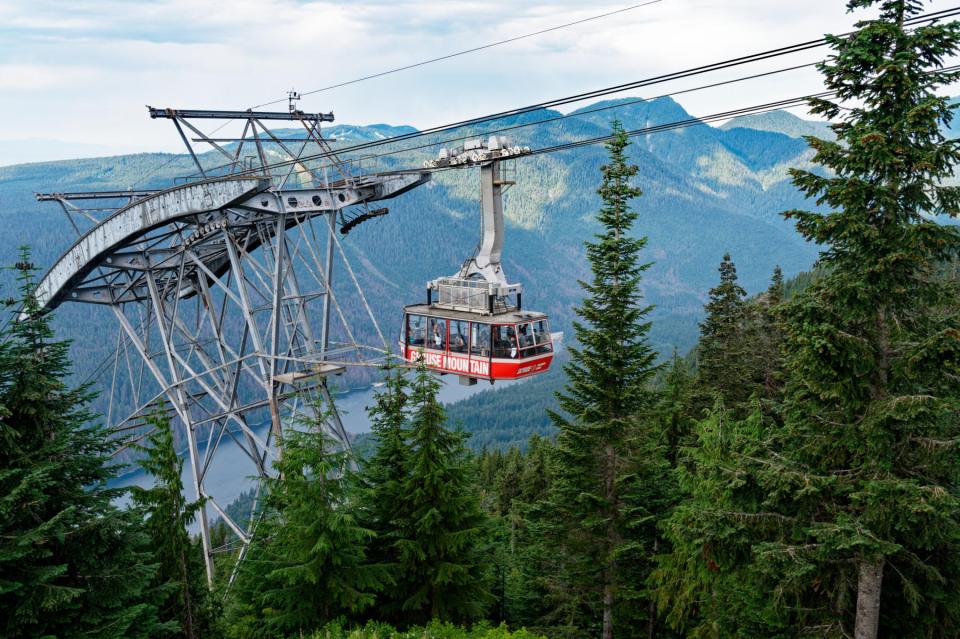
Grouse Mountain is a popular local resort which offers skiing during the winter and just the general benefits of altitude (fresh air and a decent view, ideally) the rest of the year. It all starts with a ride up in a 100-person cable car. I noticed that its maximum load was 98 passengers plus an operator, and a maximum weight of 16230 pounds. This means that the designers expected an average weight of 164 pounds per passenger. I don’t wish to be rude, but I just hope there’s some contingency built into the cable strength given the increase in the overall population’s weight since 1974 when this cable car was opened.
The journey to the top raises you 2800 feet in 6 minutes, and is exactly like cable car rides familiar to anyone who has ever been skiing except that this one has a bit of a tourist commentary from the operator (delivered, as far as I could tell in this instance, in a Yorkshire accent). At the top, you reach “Peak Chalet”, a destination which I’m sure would get Courchevel reaching for its lawyers. Peak Chalet offers a couple of viewing decks and many retail opportunities. It also has an atrium with some great carved pillars.

We had coffee there, admiring what we could see of the view, which, in traditional Walker, erm, tradition “would have been better if it were clearer”.

The area reached by the cable car offers many entertainment possibilities, such as a lumberjack show

ziplining, a raptor demonstration and a grizzly bear enclosure (we didn’t get to see the two resident bears who had wisely disappeared into their forested fastness; but the bear enclosure gave us some useful scale info).

There is a loop trail which has several sculptures hacked out of tree stumps beside it.


The eagle, particularly is a fabulous piece of work. One can take another chair lift to go even higher, so we did. My God, it’s slow. (I bet they run it faster in ski season.) It rises just 400 feet in 15 minutes, over a distance of about 2000 feet. I bet you could walk it faster, but we weren’t in a hurry, so we took it.

At the top you get a view of the middle plateau over what I assume would be a piste were it covered in snow.

They helpfully indicate viewpoints with rather fetching coloured seats.

There’s a wind turbine up there

with a fetchingly illustrated base.

We rode down chairlift and cable car to get back to our coach and Jimmy took us to our next stop, the Capilano Suspension Bridge Park. It’s too easy to assume that this bridge is the big blue suspension bridge you see extending north from Stanley Park. That would be wrong – that one is the Lions Gate Bridge. The Capilano Suspension Bridge is a pedestrian-only (you’ll see why soon) bridge across the Capilano River, which feeds Capilano Lake, which I would love to say is formed into a hydro reservoir by Capilano Dam, but it’s not, dammit – it’s Cleveland Dam. The Capilano name refers to Joe Capilano, a leader of the Squamish from 1895-1910, who fought for the recognition of native rights and lifestyle. The bridge is in a park which has a whole host of tourist delights. To get to most of them, you have to cross the suspension bridge

which is a bit wobbly.
It’s great fun to walk over, and it feels a bit like trying to stay upright walking along the length of a rowing boat in a reasonably severe cross swell, say, about force 6. It was also really quite crowded when we arrived (less so later) which added to the fun.
Once on the other side, there is a very well-engineered forest boardwalk

leading past a raptor demonstration area

(that owl has got the eye roll down to a fine art, I think…

and the Harris Hawk looks pretty unimpressed).
There’s also a high tree walk.


(Actually, I think it’s more extreme physics and engineering, but I’ll cut them some (catenary) slack on that.)


There’s great emphasis on implementing all of this as sympathetically as possible with the environment – traditional building methods, no damage to trees, no major machinery, just pulleys and ropes. It maybe somewhat confected but it’s a seriously impressive setup, and great fun to walk around.
There is one more adventure to be had, which is the cliff walk, to get to which you have to cross the main suspension bridge once more. It’s not as wobbly as the others, and is very nicely bolted on to the cliff. Just as well, really.


All in all, the Park is an entertaining place to spend a couple of hours.
The final call of the day was to the Capilano River Hatchery, which is dedicated to salmon breeding. From a single salmon pair’s clutch of fertilized eggs (which may number as much as 1,000) where six young salmon would survive in the wild, the work of the hatchery means that instead some 300 will make it through the full breeding cycle, which, as well as keeping fishermen and bears happy, has significant environmental benefits.
Beyond educational information boards (which now mean I know the difference between fry, alevins and smolts) there wasn’t much to see at the hatchery, but they did have a salmon ladder the depths of which are visible through windows. Looking at the lower levels, one could see the odd occasional salmon making its way up (normally) the ladder. Strikingly, there was something of a traffic jam at the top

and outside in the river you could make out large numbers of salmon who, one hopes, would soon find the entrance to the ladder so they could get upstream and have a jolly good spawn.

This was the last stop on our tour, and all that remained was to fight our way back through the traffic to our hotel, which gave Jimmy a whole lot more time to dispense his folksy wisdom and undoubted expertise about the city.
Tomorrow we leave Vancouver for some ten days, whilst we travel on to Vancouver Island and beyond. Victoria awaits us tomorrow (coach and ferry permitting) and then we move on to even more excitement before coming back here for a few more days. Please keep your eyes on this site and you can find out what we get up to.


