Tag Archives: Alaska

Catch As Ketchikan

Wednesday 17 August 2022 – Long read alert! Grab yourself a cuppa or a glass of something cold and settle in for a spell.

This is the last post about the cruise, for today we are At Sea, having departed our final port of call, Ketchikan, yesterday. From the decks of the ship, it looked an attractive place.

and we got prime parking position bang in the middle of the downtown waterfront. It was also clear what a major role tourism plays in its economy.

As ever it was an action-packed day, but for once our luck with the weather deserted us.

Ketchikan measures its annual rainfall in feet, and gets somewhere between 12 and 15 feet of rain every year.  If you check out this average climate page, you’ll see that “A lot of rain (rainy season) falls in the months: January, February, March, April, May, June, July, August, September, October, November and December.” Yesterday proudly performed in line with the averages.

No matter. We disembarked promptly for our excursion, a “photo safari”.  Whilst we awaited the start, we took a couple of photos from the quayside

The statue above is called “The Rock” and depicts the various influences in the development of the place – Tlingit, loggers, fishermen and airmen.

Our tour was led by Theresa

who was very friendly and helpful, but garrulous to the point of gabbling. It was only her second or third time of leading the tour, I think, and maybe she was a little nervous.  However, she had a few tips of particular value to iPhone users, but some of which could also apply to Android phones, and she took us to some nearby locations we might not have found by ourselves and some more remote ones, too.

We started at Ketchikan Creek, which runs through the downtown area.

You can see the downtown/old town buildings in the photo above, and we headed over to them. They surround a street sensibly called Creek Street and are very charming, even in the pissing rain.

I caught a glimpse of a raven slyly feeding on some scraps it had found.

Ketchikan styles itself “The Salmon Capital of Alaska”, and, since the salmon were running, we could see why.  On the positive side, one can see a salmon ladder beside the creek, where the salmon make their way upstream to spawn

but one can also see (and often smell) the carcases of those that didn’t make it – the creek waters are littered with dead salmon.

There’s a salmon sculpture by the banks of the creek, carved by Terry Pyles

and named in honour of the native carver Jones Yeltatzie, who had originally put a painted wooden salmon there.  Salmon dominate as a wildlife specimen, but there are plenty of other animals in the area, and these are celebrated in an artwork on the side of a Creek Street building.

Theresa took us to another area by the creek, where we could also see salmon working their way upstream; nearby houses were attractively coloured but a little run down.

After that we took to the road to cover a variety of different locations: a viewpoint which shows that Ketchikan has its working side as well as the quaint downtown area;

the library, which normally has a great view but today was struck by the Walker curse – “would have been better if it were clearer!” –


but which offered a nice close-up;

the harbour, which has a very extensive marina;

a floatplane mooring;

Ward Cove;

and, finally, Totem Bight State Historical park, also called Potlatch Park.  This features a replica native village, laid out as closely as possible to the traditional manner and constructed using traditional materials and hand-made tools. Construction started in the 1930s.

and, somewhat bizarrely to my mind, a small vintage motor museum.

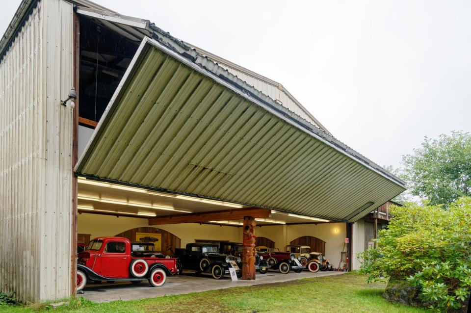
The place had the most amazing gift shop. You really don’t expect to find life-size cars in a gift shop, do you?

The gift shop also featured a museum of older artifacts (e.g. guns)

and Jane found an exquisite advert.

Our time ran out at this point and we had to hasten back for the second adventure of the day, something which was surely to be the cultural zenith of the entire cruise – the Great Lumberjack Show!

We blundered about trying to find it at first, but succeeded in the end. There was a Lumberjill outside it as we went in

to seating by an arena which was clearly set out as a competition between USA and Canada.

The host was “Lasagne Joe”, who asserted that he was a chef,

and who was the MC for a variety of different “Timber Sports” set pieces with each team of two guys trying to beat the other.

It was as staged as WWF wrestling, but massively entertaining; and the athleticism, strength and skill of the guys was very impressive indeed.  Of course, it ended in a draw which meant that a tie breaker in the shape of log rolling was needed to settle the score.

The whole thing was ridiculously good fun and the athletes posed for photos afterwards as we filed out.

It was then not long before our ship departed, so we spent a few minutes looking round at the downtown, which has its fair share of attractive buildings and quirky bits

Jane pointed out, as we walked along, that up ahead wasn’t an apartment block we had to skirt, it was our ship!

It being my birthday, we treated ourselves to champagne and nibbles – the treat was the nibbles, as the champagne was available at no extra charge – and then went to The Grill for a hot rock meal – massive prawns for Jane and steak and sweet potato fries for me.  It was a nice end to a very entertaining day.

This morning, we awoke to very different weather.

and the sun combined with a patch of fog as we had a (latish) breakfast to give us the sight of our very first fogbow!

The rest of the day passed in relative indolence, interrupted only by starting the process of getting packed up ready to be kicked off the boat tomorrow morning. Oh, and lunch, which we took at the pizza place at the far end of the deck as shown below.

I must say that it was great to see the sun.  Ketchikan excepted, we’ve been extraordinarily lucky with the weather in Alaska, but in most cases “lucky” translates as “not raining”.

As we passed Vancouver Island (and, indeed, the place we’ll be in next week in an attempt to see grizzly bears in the wild), we got some nice views from our cabin.

And thus ends a week of sybaritic self-indulgence, Silversea style.  I’m very impressed with the Silversea offering. The food has been excellent, the service has been pretty much faultless, the excursions have been interesting and varied, and our butler, Francis, has done a really superb job of looking after us all week. I would expect us to be future customers of Silversea, but we’ll probably aim for their expedition-style boats, which are rather smaller and we think that’s probably more our style.  It’ll be 2024 before we find out and there’s a lot of, erm, water to flow under the bridge in the meantime,

We still have the practicalities of getting off the ship in good order, a process which is at once both convenient and a nuisance.  Silversea demand that we have our suitcases packed and ready by 2300 today, and we must leave the cabin by 0800 tomorrow.  This relieves us of faffing about with last-minute packing, but also means that we don’t have access to things that we might normally use overnight. I’m not sure whether this is a good arrangement or not;  I guess we’ll find out in due course.

If you’ve read this far, then congratulations on your patience and staying power and thank you for sticking with it.  We reach Vancouver early tomorrow and so will have the day to wander about gawping at things and moaning about the heat (29°C, with the sun threatening to split the paving stones).  So do come back and see how we got on, won’t you?


Totem gesture

Monday 15 August 2022 – Today, the Silver Muse visited Sitka for a brief sojourn; arriving at 0900 and leaving at 1600.  The ship was anchored out in the harbour, meaning a tender was the only way to get ashore.  (Even if we’d scored a land-based mooring, we’d have been in the cruise terminal, five miles out of town, so there was little practical difference.)  Our scheduled excursion when we booked it was a “Waterfall and Champagne Toast Hike”.  By this morning, it was called an “Exclusive Rainforest Waterfall Hike”. In any case, our instructions were to assemble in the Venetian Lounge (normally used for cabaret, presentations and films) at 0835 because we had a special early tender to take us ashore. As usual, I was concerned about the weather because I don’t like being rained on and rain is not good for my camera. The forecast was not optimistic, but then none of them have been, so that offered no practical clue.

We had a swift early breakfast, once again sitting out on the rear of the ship to help us judge the conditions.  It was a little cool, but not actually raining, and actually the view was rather nice – many, many fishing boats

against a backdrop of small islands, some of which had evidence of habitation.

However, by the time we boarded the tender, the weather had changed.  I didn’t find that the view I had of the driver offered much hope for a rain-free day.

When we got ashore, it was still raining and the outlook was gloomy.

However, Silversea’s efficiency meant we had a quarter of an hour to wait for a coach to take us to our hike’s starting point, and by the time we climbed on board, things had cleared considerably.

We were driven some seven miles along the coast, to Herring Cove, and when we set off for our hike, the rain had stopped.  Eric, our guide, gathered us round for some introductory remarks,

including such topics as: what to do when we get charged by a bear (let him handle it and don’t run away); avoid the plant called Devil’s Club

because leaves and stems have barbed spikes which will cause you real discomfort and which are very difficult to remove; and watch your step, because the locals are dog-loving, but, more importantly there might be banana slugs on the path – their slime, when it comes into contact with water (e.g. on the sole of your shoe) turns to glue, so it’s not wise to tread on them. We did see a couple, such as this one, which was sporting “chocolate chip cookie” colouring.

That said, Eric explained that the local, Tlingit, natives knew that Devil’s Club plant leaves could be made into a tea which was therapeutic treatment for lung problems, and roots, bark and stems also had medicinal value which is currently being scientifically investigated; and the banana slug’s slime, as it trailed along, trapped and dispersed seeds and pine cones which promoted further forest growth.  Not all bad, then.

Although it wasn’t actually raining, we were in rainforest, and Eric showed us what that meant for the local vegetation.  Much new growth comes from old stumps

and some trees that grow this way can throw roots round the stump they grow from and eventually overwhelm it.

To English eyes, it’s a weird woodscape

but there are many undeniably attractive sylvan scenes

and occasional glimpses of the sense of humour of the locals who maintain the tracks and look after the forest.

It’s clear that there’s a solid maintenance effort along the trail

though there are places where nature has made her own pathway for hikers as well.

The river which flowed alongside much of our walk is a delightful accompaniment.

In places the trail was quite steep

(you can spot Eric way up the trail)

but overall it wasn’t a hard as the Mount Roberts trail we’d done a couple of days ago – better maintained, less muddy and, most importantly, shorter; we climbed just 186m before we saw the Bear Mountain Falls

(sorry – difficult to do the view justice in a photo, but a lovely sight). At this point Eric produced the aforementioned champagne and we all drank a (very small) toast – can’t have drunken tourists stumbling about the rain forest!

We retraced our steps to the bottom of the hike and were taken back to downtown Sitka. Rather than take an immediate tender back to the ship, we decided to go for an amble, with the main objective being the Totem Park. The route took us through downtown Sitka

where the totem pole influence was difficult to miss.

Another key influence from history is clear to see, in the shape of the Russian Orthodox Church, St. Michael’s Cathedral, which is central in downtown Sitka.

The Russians first came as a consequence of Tsar Peter I’s Great Northern Expedition, which spilled over into Alaska.  The Russians wanted to exploit the area to expand the Siberian fur trade, but when they expanded to south east Alaska, the Tlingit resisted this expansion because they already had deals with America and Britain. It didn’t end well; in 1802 the Tlingit destroyed the Russian outpost north of modern day Sitka and in response the Russians returned in 1804 and fought to establish a new settlement, which was contested by the Tlingit for many years until a settlement was eventually reached in 1867.

On our stroll through the downtown area, we stopped off to get some reindeer dogs at a recommended place

and ate them sitting opposite a local ukelele band

who did their best, bless them, to overcome the ukelele’s fundamental drawbacks when harnessed as backing for popular songs.

There are some undeniably attractive buildings and some other quirks in Sitka

(let’s complete the set, here….)

(oh, the dolphin is in front of the Episcopalian Church and, in the competitive nature of these things, there’s a Catholic one close by).

There’s a very extensive marina

and even a local salmon ladder, part of the Science Centre Hatchery, which we watched a few fish try to climb; but somehow we didn’t find Sitka as attractive as we had found Skagway, I’m not quite sure why.  Sitka has the amenities and the facilities but somehow, it seemed to us, lacked the charm.

However, one thing it does have which is fairly unique is the Sitka National Historical Park, or the Totem Park for short.

This features, unsurprisingly, many totem poles along a forest trail. But before we got there, a chap engaged us in conversation, which often is a heartsink moment. However, this chap turned out to be Edward Milan, a Tlingit Indian who had actually carved the pole in the foreground here (and has written books on the subject, it turns out), with whom we (mainly Jane, I was taking photos) had a gentle conversation about the history and the modern practice of creating totem poles.

We also found the workshop where poles are being carved.

Just entering on the right above is Tommy Joseph, who showed us some of the tools he works with and helps create for his students.

Our claim to fame, then, is that we have talked to the man who created the Blue Peter Totem Pole.  He is justifiably proud that he got a Blue Peter Badge for it.

We walked a trail through the park.  There are several totem poles along it, collected from various south eastern Alaskan villages by Alaska Governor John Brady and erected in this special park after the poles had been displayed at two world fairs in an attempt to attract newcomers to the area. In many cases the older ones have been refurbished and/or re-carved by Tommy Joseph who has also created new poles addressing modern life.

Totem poles originally stood in villages near the ocean where travellers could see them, advertising the wealth of the village and/or commemorating important people, events and legends.  Often the modern world doesn’t even know what the symbols originally meant. Here’s a montage of some of the things we saw.

We then hastened back to one of Sitka’s landmarks and useful navigational aids – the bridge

where we awaited the tender to take us back to the ship.

For some reason, I find the head poking out of the top of it amusing – it’s the chap who’s driving the thing.  Anyway, aside from a small collision with Silver Muse, we got safely back, having had an engaging conversation on the way with a father-and-son combo – Dad from Virginia, son from San Francisco.

And that ends the story of the day – yet another fairly full-on one.  We treated ourselves to in-suite dining whilst I cobbled these words together, and now it’s time to get our heads down before our next and final Alaskan port of call – Ketchikan.  We’re booked on a “photo safari”, which I hope I will find interesting, but during which I can imagine Jane will be quietly rolling her eyes on occasions.  Come back tomorrow and see whether I got the “iconic images” that the blurb promises!

Skagway – It’s The Rail Thing

Sunday 14 August 2022 – Another eventful day beckoned, which meant, you guessed it, an earlyish start, for we had to be out and about by 0845 with our tourist faces on. The weather forecast was once again uncertain about whether it would rain, and the view at breakfast supported that uncertainty.

It was cool, but we were still able to sit outside for breakfast which was pleasant. We decided that we would laugh in the face of the prospect of rain, mainly because we would be spending almost all of our tourist minutes under cover: the morning was a train ride, the afternoon a trolleybus.

Rather conveniently, because Silversea had managed to get a good parking spot for the ship, the railway came to us, rather than us having to be ferried to it. A short walk took us to our train

and what seemed like a slightly longer walk took us to a carriage which we picked randomly. As carriages go, it was fine, but (from a photographer’s perspective) we should have taken a carriage near the rear of the train for maximum cute “here’s the train going round a bend” photo potential.  And once we were in a carriage and a kindly gent dressed as a ticket inspector had, erm, inspected our tickets, we were enjoined not to move carriages, so we had to make do with where we were.

Where we were was towards the front of a train that would take us along the White Pass and Yukon Route.  This is a railway that in its entirety goes to Whitehorse, the capital of the Yukon Territory in Canada.  We would not be going that far today – simply climbing nearly 3,000 feet to the White Pass summit, looping round and coming back down again, a distance of around 40 miles in total. The Silversea blurb described it as a scenic railroad journey, so I had high hopes of being able to take photos of some, you know, like, scenery and that.

The railway has a huge historic influence on the origins of Skagway, all bound up in the 1896 Yukon Gold Rush. Skagway (we learned later, as you’ll find out if you keep reading) has unique attributes – the furthest north deep sea port, and a convenient notch in the surrounding mountains to make access a fraction less than impossible.  There had been two routes from Skagway to the Canadian Klondike: the ridiculously steep Chilkoot Trail and the longer but flatter White Pass. The founder of Skagway, William Moore, discovered the White Pass and busily set about creating an infrastructure to exploit support the hopefuls who would rush there in their tens of thousands in the – faint as reality demonstrated – hope of getting rich. Part of that was getting a railway built; this started in 1898 and it took just over two years to build the route.  For many years after the gold rush it was used to carry ore and concentrates to the deep sea port of Skagway, and then, after a period of disuse, it was reinvented as the tourist attraction it is today.

It is scenic, but in the early part of the journey those damned trees tend to get in the way of the view. Inside the carriages, a (rather stilted) commentary is broadcast, including alerts for things to look out for.  However, the best place to be to take actual photographs is standing on the platform outside the compartment, where you can’t hear the commentary.  So I spent practically the whole journey standing outside on the carriage platform, which was a bit chilly. I missed a few decent shots on the way up; but since the way down is simply the reverse, I made some mental notes of things I wanted to capture if possible on the return journey.  There were gaps in the trees to capture the odd scene, though

(that’s Skagway in the distance – you can tell by the cruise ships) and Jane did a great job of passing on alerts from the narrator to give me the best chance of catching decent scenes.

Bridal Veil waterfall

a bridge higher up on the railway – looks dangerously flimsy to me.

Regrowth after a landslide, or glacial erosion

Going over the “flimsy” bridge.

A steel bridge, in use until 1969 and once the tallest cantilever bridge in the world.

Eventually, we reached the border with Canada, marked with an obelisk and the flags of each nation

and we looped around and headed back down again – stopping, somewhat bizarrely, for customs purposes when we reached the US border.

I caught some video on the way down

and also this scene, which was one I missed on the way up and wanted to be sure to capture.

The train duly delivered us back to the ship, where we snatched a swift lunch before heading out for Phase II of the day – a Street Car tour of Skagway.

Our driver and guide was Anna,

who was clearly a larger-than-life character and had a robust delivery to match, full of historical nuggets and pungent comment. She took us around Skagway, which is a very attractive little town, telling us stories about the buildings we passed;

the church, for example, was the first granite building in Alaska.

She took us to an overview point to give us a, erm, overview of the town

before taking us to the Gold Rush Cemetery, where many who died during the gold rush years are buried.

Two key characters in the development of Skagway were the villain, Jefferson Smith, who got the nickname “Soapy” by conning customers with bars of soap, and the hero, Frank Reid, who killed Smith.  Actually Reid was a thief and murderer on the run, but that seems to have been forgotten because he was the cause of Smith’s death, as part of which, he himself was killed.  Anna, as one might expect, milked this strange and sorry saga for all it’s worth.

Anna ended the tour back in town, which gave us the opportunity to go for a quick walk around it taking better photos of this attractive place than can be easily done from inside a bus. There are many colourful timber buildings, especially on Broadway along which the railway used to run

including the Skaguay News above, which used to publish the news regularly, once every month. (The original name of the town was Skagua, meaning “that windy place” in the Tlingit tongue, and the name has since been anglicised). There was the odd occasional mural or other quirky item,

an extraordinary rotary snowplough for clearing the railway,

and a statue of Skookum Jim, a Tlingit native, and Captain William Moore, representing their discovery and mapping of the White Pass.

This brought us back to the ship for its 4pm departure for our next port of call, Sitka.  We’re due to go on a hike and much scenery is promised in the blurb about it.  Therefore, in theory, there should be some lovely photos to look through tomorrow to distract you from my commentary.  You’ll just have to check in to find out, won’t you?