Tag Archives: Iceland

Day 13 – Water goes up…must fall down

Sunday 11th July 2021. The plan for today was Golden Circle day. This is basically the route that tourists who are based in Reykjavik can use to see The Sights, the main ones of which are Geysir (water goes up), Gullfoss (water falls down) and Þingvellir National Park (water stays where it’s put). We expected to tick those boxes in pretty short order before retiring to the bar in our Reykjavik hotel for a G&T before some kind of extravagant dinner. We ticked the boxes all right, but the day didn’t quite work out like that… in a good way.

Our extreme good fortune with the weather didn’t hold, and we had a grey, windy and occasionally wet day, with the sort of driving drizzle whose ubiquity has probably earned it a special Icelandic name. It didn’t interfere with our enjoyment, but it’s not the weather that a photographer would normally choose.

Before we got to the major part of the box-ticking exercise, Dagur took us to the cathedral, just down the road in Skálholt.

Skálholt has a major place in Iceland’s history. It was an episcopal See, a school, a seat of learning and administration for more than 700 years and a place of pilgrimage in medieval times. The present Cathedral was consecrated in 1963 and is the 10th church standing on exactly the same site. In it is a list of all the Bishops stretching from the current (female) one right back to the first one, who took office back before Willam the Conqueror decided he fancied a bit of English rule. It was, unlike most of the Interesting Churches we’ve seen this last fortnight, open, so we went in. It’s a lovely interior.

The stained glass is very striking, as is the mosaic above the altar. There’s an escape tunnel to the outside, used both for exit and entry in emergency, e.g. attack by a band of marauding riffs.

and in the grounds is a replica of the type of house that once also stood on the land.

Our next stop was also something that’s not on your normal Golden Circle tour – an amazing place called Friðheimar. To say baldly that they grow tomatoes there is technically accurate but utterly misses the point of how they go about it and the scale of the undertaking . The creators, Knútur Rafn Ármann and his wife Helena Hermundardóttir, have created an environment in which they can be grown year round.

Geothermally heated greenhouses and a carefully controlled growing process ensure that light, nutrients, water and heat get to the plants

and they keep bees to pollinate them.

They also, by the way, grow cucumbers and lettuce – over a ton of produce every day of the year – and have even put a restaurant in place so you can eat a meal in the surroundings. It’s rather surreal – a lush, green, warm oasis amid Iceland’s rather more hostile environment.

After this – at last! – we got on to the first of the major Golden Circle attractions – Geysir.

Well, actually – not. The original Geysir, whose name is now used worldwide to refer to such phenomena, has not erupted, with maybe a couple of days’ exceptions, for decades.

Here’s a picture of the dormant Geysir, taken by a dozy old geezer.

However, on the same site is its little brother, Strokkur, which is active. As might be expected, there’s a crowd of people waiting for the next eruption

which, although not as high as Geysir was, is quite impressive when it happens.

View this post on Instagram

A post shared by Steve Walker (@spwalker2016)


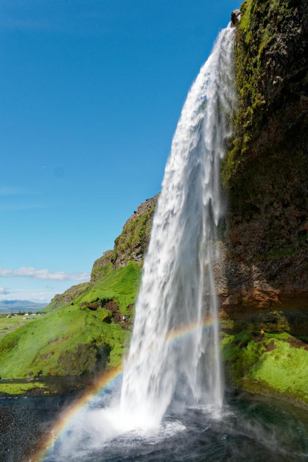
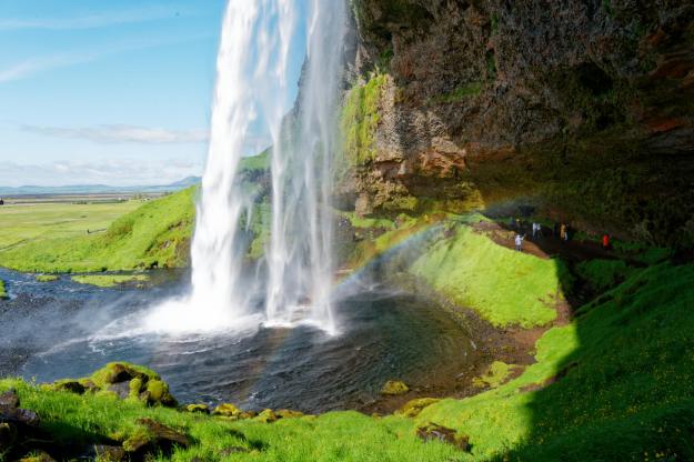
We then moved smoothly on to the next box to be ticked – Gullfoss, the Golden Waterfall, billed as Iceland’s version of Niagara. I’ve never seen Niagara, so I can’t comment on that (come back to this blog in October next year for my thoughts on it, if plans go according to, erm, plan). It’s pretty substantial.

So substantial, in fact, that it’s quite difficult to convey in still photography. There’s a high viewpoint which enables a video panorama, which I hope helps you a bit more with its scale.

View this post on Instagram

A post shared by Steve Walker (@spwalker2016)


Our next stop was at the rather unusual home of “The Cave People“.

The idea here is to re-create the sort of environment that Icelandic people, typically shepherds, lived in long ago; and about a century ago, this house was used by Icelandic couples. There are a few mod cons visible – solar PV and a small wind turbine – but otherwise the Caves have been rebuilt to look exactly like they did when the last Cave People in Iceland lived there only a century ago. You can take a tour if you like, but we didn’t because the next box to be ticked was calling – Þingvellir National Park (pronounced “Thingvellir” by the way).

Þingvellir is the National Park where the Althing, an open-air assembly representing the whole of Iceland, was established, way back in the year 930 and continued to meet until 1798. Over two weeks a year, the assembly set laws – seen as a covenant between free men – and settled disputes. It’s held to be the world’s first Parliament. There’s a pole erected to mark its place.

Behind the pole, you can see the wall of rock which marks the start of the American Tectonic Plate.

This “wall” is visible from some distance away as a line across the landscape. Anything this side of it is therefore in Europe.

From a viewpoint on top of the wall, you can see people walking between it and the European Tectonic Plate. The two plates are moving apart at some 2cm per year, but I still assert that it takes some courage to walk between them, just in case the middle bit collapses.

There is an Interesting Church across the river

and a very nice, calm lake

(in this windy country, you rarely get lovely calm reflections like this).

So that was the Golden Circle well and truly ticked off. But Dagur had a couple of “extras” for us, some less expected than others.

The first was a visit to The Volcano – the recent eruption near Fagradalsfjall. Bearing in mind that the actual eruptingness of the volcano was no longer visible to pedestrians (and any available helicopter for miles around was fully booked to fly over the site), and all that could be seen was lava, I frankly had low expectations for something that took us two hours out of the way between me and a refreshing gin and tonic, particularly since the weather was looking rather grim – after all, we’d seen quite a lot of lava over the last couple of weeks.


When we reached the site, it was evident, though, that it was still a popular day out

and as we walked towards the lava flow there was a constant flow of people coming back from it, with a huge variety of languages among them, and none of them, even the ones carrying expensive-looking camera equipment, looked dejected. And, in the end, after a 20-minute hike along a defined path but across somewhat broken ground, we reached the start (or, to be more accurate, the end) of the lava flow.

It was actually a very interesting experience, despite poor visibility. You might be able to make out the lava field receding into the distance and splitting round a hill; we walked about half a mile along the left hand side before it became clear that you could walk for a further hour or two and see still more lava. To give you a better idea, here is a photo that Dagur sent us some days before our trip started.

You can see where the lava flow has split around a hill; our half-mile walk took us just short of the “blob” of lava on the left, somewhat before the split – so you can see that it’s a very, very large lava flow.

As we approached the lava flow, the first thing that struck me was the smell. It was a singed kind of smell, but not, as it were, “natural”. As Jane said, it was the sort of burnt plasticky, rubbery smell that a photocopier makes as it goes seriously on the blink.

And the second thing was the heat. It wasn’t very hot, but there was a sense of a vast amount of powerful warmth emanating from the lava – and the very real understanding that setting foot on it would be a foolish thing to do, the sort of total fuckwittery that only Instagram selfie addicts might try and which will hopefully lead to the Darwinian extinction of that vapid species.

The lava gave rise to some interesting abstract image possibilities.

All in all, I’m glad that Jane insisted we do the trip to the site; even though there were no eruptive fireworks to marvel at, we came away with a sense of the enormous power that lay beneath, despite it being (for the moment) quiet.

Then Dagur sprang his last two surprises on us. One was a visit to a major tourist site – the Blue Lagoon. Although it’s quite close to the eruption site, we hadn’t expected to see it, so it was a nice little fillip for the end of the tour. Again, it’s one of those places where the basic description – a lagoon of black rock containing blue water – doesn’t cut it to convey what the place is really like.

There’s a hotel and spa there, where guests can frolic in the water (which frankly looks toxic to me)

and they can even buy beauty face masks if they’re completely unselfconscious.

But you can also walk around the lake proper, and it is a weird and wonderful sight.

By this stage, it was getting quite late, and we thought that these two diversions had eaten rather heavily into Dagur’s time and goodwill; but he sprang one more surprise on us…..

Dried Fish.

This might not sound much, but….

there’s a site outside Reykjavik which is so little talked about that even the locals don’t have a formal name for it. It’s a site where fish are hung for up to three months to dry them before they can be used for some local products (e.g. in cat food) and also for export – apparently the eyes are a delicacy in Nigeria…

It’s an extraordinary sight -rack after rack after rack of – fish, being hung out to dry.

And thus ended our second week in Iceland and the touring aspect of our holiday here. We’d covered 2,000 kilometres, taken 2,000 photographs and presented nearly 400 of them on this blog (oh, I’m not done yet, though!) It has been fascinating, educational and often awe-inspiring. I’m absolutely delighted to have documented it through these pages, because there is no way I could have remembered a tenth of what we’ve been told and what we’ve seen otherwise; and we were both utterly knackered and quite glad to get back to Reykjavik, check in to our final hotel, hotfoot it out for burger and stellar chips once again at Reykjavik Chips (see the “Cry Freedom” blog), and – relax. Our brains are full. Full of the sights, sounds and smells of an extraordinary country which it has been our pleasure to travel round and our privilege to see in largely beautiful weather. As a way of breaking out of UK’s Lockdown it simply couldn’t have been bettered.

As I say, I’m not done with you yet; we have a day at leisure in Reykjavik (and the rain, if the forecast is anything to go by), and we have to do some Covid-type admin before we leave. I’ll report how the day went in the next post, and hope you come and join me there.

Day 12 – Yes, We Canyon!

Saturday 10th July 2021. One loses track of time on an excursion such as ours. It was something of a jolt to realise that it was the weekend, at least for everyone else; we just carried on in our little dream world as we explored the southern region of Iceland before joining the “Golden Circle” route tomorrow. And, probably, hordes of bloody tourists.  We’re now within range of day trips from Reykjavik, and it showed in the number of punters and the number of coaches at the various places we stopped for a gawp.

The first of these was yet another Interesting Church, this one on the site of a medieval convent at Kirkjubæjarklaustur, very near our hotel.

Like almost every Interesting Church we’ve come across, it was closed, and I have yet to hear a credible explanation of how come there are all these churches which seem almost universally to be unused on any kind of a regular basis.  Is there a vicar or priest? Is that person a visiting official? Who pays for the upkeep? etc, etc. Anyway, it’s lovely to see such interesting church designs; and this one is not the last of this trip.

The next place we went to has to be one of the most arresting sights of our holiday in Iceland. It’s called Fjaðrárgljúfur and is billed as a canyon.  As you approach it, you begin to get some idea of what awaits.

Then you look carefully and you can just make out a couple of sheep as the merest dots (just left of centre in this picture)

and then you climb to the observation platform and see this

This was the first Shot Of The Day. It is a truly awesome sight, without being completely overwhelming (like, say, the Grand Canyon is).  A remarkable start to our day. You can walk down towards the other end, passing some sheep

(one was sleeping and we hope it didn’t really drop off) and have a look from there.

There’s a figure on the right bank as we look along it from here, and that gives some idea of scale.

We next got a chance to see a couple of uniquely Icelandic things.  The first was a sheep rounding circle.

There are half a million sheep in Iceland – more than the number of resident people – and they are basically free to roam.  This means that you can come across them almost anywhere, sometimes, alarmingly, in the middle of the road as you drive along.  Somehow (by horse, dog, 4×4, anything that works), every September these wandering sheep are rounded up from wherever they’ve got to, a convulsive effort over around three days which is a massive part of Iceland’s culture and something that all farmers have to join in on.  The sheep are herded into the central pen and then individual farmers pick out their sheep (they all have ear markings) and separate them into that farmer’s segment.

The second insight came as we got a chance to try to grasp the impact of an enormous event in Iceland’s – and indeed the world’s – history – the Laki Eruption of 1783-5.  This was of staggering size and impact: an outpouring of an estimated 42 billion tons or 14 km3 (3.4 cu mi) of basalt lava and clouds of poisonous hydrofluoric acid and sulfur dioxide compounds that contaminated the soil, leading to the death of over 50% of Iceland’s livestock population, and the destruction of the vast majority of all crops. This led to a famine which then killed approximately 25% of the island’s human population. The lava flows also destroyed 20 villages. The eruption and its aftermath caused a drop in global temperatures, as 120 million tons of sulfur dioxide was spewed into the Northern Hemisphere. This caused crop failures in Europe and may have caused droughts in North Africa and India.

We stopped in the middle of the huge lava field resulting from this eruption.  It’s difficult to convey the scale of it – kilometre after kilometre of moss-covered lava, because only moss – nothing else – will grow on lava, and this takes centuries to develop.

I created a Facebook 3D photo which might help to underline the scale of this.

Our next port of call was what Dagur called the “Yoda Cave” – actually used as the setting at the star of Star Wars – Rogue One, as the cave our heroine dashes into to escape from some band  or other of marauding riffs.

It looks quite impressive from the inside as well.

This is in a part of Iceland that used to be an island, but the volcanic actions raised the land up around it.

This is close to a town called Vik, which has an Interesting Church, more for its location than its architecture.

In the distance to the left can be seen the “Three Trolls”, Reynisdrangar, rocky outcrops off the beach, Reynisfjara. You can get a closer view of them from Vik’s black sand beach.

We headed over towards them and I guess this was the first time we came across hordes of tourists – Reynisfjara is a popular spot and the car park was crowded. There are a couple of lava caves

one of which has basalt columns by it – popular for kids to climb on.

We carried on along the coast a short way, stopping at the clifftop at Dyrhólaey, which has a view over an impressive rock arch

as well as the surrounding countryside

it’s own troll

and – delightfully –

puffins!  Dagur explained that these are often blown over from their usual colony to the east during August.  The fact that some are here at this time of year, and that they appear to have burrows that they are using, implies that this is becoming an established puffin colony in its own right.  I took loads of pics, obvs, and even nearly managed an in-focus one of a puffin flying off.

But the wind was gale force and so hanging about to try to get a better photo was not a comfortable option. We moved on.

The southern region is marked out, as I posted yesterday, by glaciers and the road to our next major stop offered a chance to get a nice picture of one of them – an offshoot of Vatnajökull, but I don’t know which one, I’m afraid.

The rest of the day was almost exclusively about waterfalls, which was a relief.  It’s been ages since we saw a decent waterfall and I was beginning to get withdrawal symptoms.  Our next stop, then, was at Skógafoss, but we were hungry so stopped for lunch at the hotel there before exploring the waterfall itself.

And it’s a splendid sight.  The car park was crowded, as was the shoreline, with lots of people getting in each other’s way as everyone tried to get fucking selfies, which always enrages me. Mind you, I did manage to get something out of other people’s cavorting.

By aggressive use of sharp elbows, I got to the front where I had a few seconds to get a view of the falls unsullied by tourist vapidity. But actually, the second Shot Of The Day came about as a girl walked in even further through the spray towards the falls and gifted me with the perfect shot.

Before the next waterfall, we stopped briefly to view some turf houses in a place called Drangshlíð.

I found this post about them on the web, but it didn’t really leave me any the wiser.

A few kilometres along the road we stopped at Seljalandsfoss, which is another great sight.

It’s very popular, as it’s a waterfall you can actually walk behind

after having done which, you can walk along to another one, called Gljufrabui.


View this post on Instagram


A post shared by Steve Walker (@spwalker2016)


And that was nearly it for the day’s interesting bits.  We are staying the night in the Sel Guesthouse near Skalholt, and it is a charming place.  Though the charm is somewhat rustic, it has WiFi and other mod cons, geothermal hot water in the bathroom, but no restaurant.  So we made our way to the Farmhotel Efstidalur, which really is a working farm.  From the cafe, you can see the cows

and upstairs in the restaurant you can eat them.  We had a pulled beef salad which was absolutely delicious.  Then we indulged ourselves with some of their home-made ice cream downstairs.

Thus ended our day. We will be Doing The Golden Circle tomorrow, with the major tourist sites and sights that this offers. It should be a good day, and it’s our last day on this tour, so let’s hope for a final Grand Day Out. Please check in tomorrow to see what actually happened, why don’t you?

Day 11 – Ice to see you – to see you, ice

Friday 9th July 2021. Warning! Lots of pictures!

Today was the day we made the move from the eastern region to the Deep South. This journey goes round the south side of Vatnajökull glacier, Europe’s largest glacier at around 8,000 square kilometres (some say more, some less). Unsurprisingly, it, and its offshoots, formed the mainstay of today’s sights.

We started the day, however, with an experiment. As any fule kno, Iceland is a long way north – just south of the arctic circle – and so at the time of our visit the summer days are long enough that the midnight sun comes into play. Blackout blinds are an important part of hotel room decor to ensure that the rooms can be dark enough to sleep in, for example. We thought it might be interesting to demonstrate how light it was at midnight, so took a photo from our hotel window (actually, 2330, but cut us some slack, here, OK?).

That’s a little gloomy, but not actually very dark. I then took a photo at 7am using exactly the same settings, expecting it to not be that much brighter, underlining the lightness at midnight.

So our impression, that it’s not that much darker at midnight than at 7am, was wrong, then. What it demonstrates is that while it is certainly not truly dark, the human eye and brain have very strong compensation capabilities.

Our first major event of the day was to be a trip on a Zodiac RIB across a glacial lake, Jökulsárlón, to have a close encounter with Breiðamerkurjökull, a sort of “finger” off the main Vatnajökull glacier. But before that, Dagur took us a little off piste to have a look at a different finger, called Heinabergslón, which gave us a couple of decent images and a good build-up to the main act, as it were.

Then it was time for our boat ride. There are a couple of operators offering RIB rides across the lake, running from a rather ramshackle car park. You can actually get quite a good view of the glacier and some icebergs from the shore there.

Our operator was Ice Lagoon Tours who did a good job of getting us kitted out with insulated waterproof overalls (I’ll spare you the picture, mainly because I haven’t got one) and bussing us out to a pair of RIBs. I was somewhat nervous of getting my Big Camera damaged by spray, so took a Rainshield bag with me; it turned out to be not necessary and I’m glad I did take the Nikon, rather than the smaller, tougher, waterproofer but less capable Olympus Tough that I also had available.

The journey across the lake is actually some 7km, and is undertaken at some speed (a big spray risk on a rough day which thankfully we didn’t have).

On the way over, I noticed a button on the boat which seemed to be very significant for an Icelandic operation

but rather prosaically is simply part of Suzuki’s engine speed management systems.

Once we arrived near the glacier, our skipper, Erik, slowed down so we could stand up and take some photos. Of course, I took lots, and here are some of them.

The dark lines across the glacier indicate the time of an eruption when ash and rubble was laid down; so you can drill down into a glacier to go back in time for research purposes.

There were some icebergs floating near the glacier and some of them showed the fantastic blue colour that is so attractive.

There were a couple of seals lazing around on the floating ice. Jane’s ever-eagle eyes spotted the first one, and Erik took us close enough to each of them to get some photos.

and then it was time to head back to the start, across a bracingly bumpy but thankfully pretty dry stretch.

After this excitement, lunch was needed, and this is where the ramshackle nature of the car park became most obvious. For one of Iceland’s most popular tourist attractions, one might expect a well-organised retail operation; but one would be disappointed. There are a couple of food outlets, some loos and the boat operators and that’s it; and the food options are somewhat limited. The caravan selling fish and chips (called “Nailed It” for some unfathomable reason) had no queue, so we ordered some, and very good they were, too.

Just along the road is something called the “Diamond Beach”, so-called because you can find lumps of ice on the black sand; the ice lake flows out via a river that reaches the sea at this beach, hence the presence of ice. This is better seen in winter, as for us, the ice was pretty sparse.

failing even to impress a skua who was watching the tourists at play.

More glacier action featured at our next stop just down the road at another finger off the main glacier, called Fjallsárlón, where I got another bunch of decent photos; the one below gives you some idea of scale through the tiny figures you can see in the foreground.

After all that ice, it was time for a break and this came in the form of a visit to Hofskirkja, the last turf church ever constructed in Iceland, originally constructed in 1884, though it was thoroughly restored in the 1950s. Unlike some of the country’s other turf churches, this one is still a practicing parish.

There was a very agitated bird, a Redshank, which was loudly complaining about our presence and therefore presumably had a nest somewhere near.

so we left the poor thing in peace (eventually) and moved on to our next glacial encounter, at a place called Freynes, yet another finger reaching down from the main Vatnajökull glacier. This involved a bit of a hike and a scramble over some gravelly rocks, but this yielded some good photos.

After this we had a slightly surreal interaction with a bridge that was part of the old Iceland Ring Road and which is now no longer in use; Dagur wanted to drive up on to it and so we helped him find the track so he could put his Land Rover to good use. Bizarre, but he was happy to have done it, so there we go.

We then got back into proper Tourist Mode for the final sights of the day as we headed out of the eastern region and into the Deep South. At one place, near the hill where the King and Queen of the Elves live, yes they really do,

is a good example of what happens to the lava of an eruption over time. The only thing that can grow on lava is moss. So you can see the edge of a lava flow by where moss grows and where it doesn’t.

The moss above is actually yellow moss, but because it’s been dry it has lost its colour until the next rains. The grass is growing in soil and you can clearly see where the grass can’t grow and is replaced by moss. This is from an eruption some 250 years ago, so the process of moss growth is very slow.

Lastly, because we’re in Iceland after all, we visited a couple of waterfalls, the first labelled by Google Maps (rather unconvincingly, in my view) as “Foss midway li la lo”

and the second Foss a Sidu.

After this we went to our hotel, the Magma Hotel in Kirkjubæjarklaustur. This is a very attractive place, with a main building housing reception and restaurant

and rooms in the shape of turf-roofed cabins.

We had a very nice dinner, and then decided to go for a brief stroll to explore, because the setting is so pleasant.

You’ll notice the horse in the picture above, and there were some in an adjoining field.

of which two came over to say hello – lovely creatures and very engaging they were, too.

Thus ended the day. I would apologise for the large number of photos, but then it’s been that kind of a day, and I hope you have liked some of them. Tomorrow is likely to be the same – not many miles covered but a busy agenda, so do please come back then and see what we’ve been up to, won’t you?