Author Archives: Steve Walker

About Steve Walker

Once a tech in-house PR type, now professional photo/videographer and recreational drone pilot. Violinist. Flautist. Occasional conductor. Oenophile.

The End Of (holi)Days

Thursday 10 October.  Today was our last day of holiday, and we travel home tomorrow.  It seemed a shame to let the day go idly by, so we elected to do a short walk, going west from our hotel.

We traversed Mahon, going further west than we’d been during our week so far, encountering new and strange objects such as this sundial.

I’m not quite sure how it works, but it has strange and wonderful markings.

We had to deal with the Mahon ring road, and soon encountered the first major landmark of the walk, the Hermitage of St. John, now sadly falling into disuse.

We also passed a memorial to Sir Richard Kane, the island’s first British Governor.

He is responsible for many good works, such as reforming the legal system, drawing up a new constitution, building a road connecting Ciudadela, with Mahon and making Mahon a free port.  He also got a drainage ditch dug to drain the marshland to the west of Mahon,

creating a fertile agricultural area, which to this day is effectively the market garden of Mahon.

The walk was largely an out-and-back through this area of allotments and more major agricultural areas.

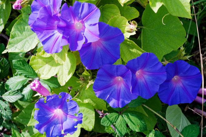
There were several patches of Morning Glory

and the road was literally crawling with Hawk Moth caterpillars of a variety of hues.

(sadly, the road was also liberally covered in the squashed corpses of caterpillars which didn’t make it).

We saw a couple of kites

and an egret (just one, this time, although on other occasions, we’ve had a few).

Having gone as far along the track as we could, we retraced our steps as far as the hermitage, and then branched off on the old track which was once the only way into Mahon.  Most of it was Menorcan-style rough cobbling with small stones, here with cart track ruts visible

and there was a very short stretch of what was the more sophisticated Roman version of this road.

A fairly gentle walk, then, was our last on the island.  We headed back to the hotel before going out for a final lunch at a restaurant called L’Arpo – good razor clams but not exceptional tuna – and then coming back for a little post-prandial siesta.

Tomorrow, They’re Coming To Take Us Away at midday and we go home after three wonderful weeks in Spain.  I’ll try to do a summary of my thoughts about it as a wrap up to our excellent Spain B&B Break.

A Walk of Two Halves**

Wednesday 9 October. With effectively two days left of our holiday, we had a significant decision to make – lounge about doing nothing or Get Out And Do Something?  Realising that the former would be a big part of our lives once we got back home, we resolved to do the latter and Jane (who else?) came up with a plan, which was to do walk no. 4 in our “Landscapes of Menorca” book. This was described as possibly the most interesting walk on the island, and was 10 miles long, which seemed achievable, given the presence of cafes en route to seek refuge from the pitiless sunshine that was forecast.

During the first half of the walk, I was beginning to have a Peggy Lee moment: “Is this all there is?” because frankly we were just slogging along roads (albeit quiet country lanes) and tracks in the streaming sunshine with little more than dry stone walls and fairly arid fields to look at.  There were occasional highlights, such as this mystery object

(later identified as a threshing floor*), defensive towers (set up historically to defend against pirates rather than the modern invasion of tourists)

and some charming properties, many with the bentwood gates made from wild olive trees that are typical of this region.

However, at the halfway stage, as we turned to come back in the general direction of Mahon, things suddenly got more interesting.  We left the formal road/track/stonewall infrastructure for a  more open track across scrubland which had much more appealing views

and among which some more interesting wildlife could be spotted (or, possibly, striped).

We passed a defensive tower, Torre d’en Penjat, built in Napoleonic times

as we headed towards the ruins of the Sant Felipe fortifications which are what lend the suburb of Es Castell its name.

(just beyond the fortifications is one of the yellow “glass-bottomed boats”; catamarans which offer tours of the immense Mahon harbour.

This area has a lot of military overtones, both current and historical. As we carried on our way, we passed other historical remnants of fortifications and approached the area of Fort Marlborough with its crossfire redoubt which enabled 50 British soldiers successfully to defend against 700 French

This whole area is very photogenic (this is the appropriately named Cala Sant Esteve – St Stephen’s Creek!)

as is the rest of the walk back to Mahon, which starts with something billed as possibly the oldest road in the island, of Roman construction, and part of the “Cami de Cavalls” track which is a 180km track going right round the island.

We had been walking in direct sunshine for some time – over two and a half hours – by this stage and something which buoyed my progress no little was the prospect of a rest at a cafe nearby.  Sadly – tragically! – this was shut and we had to soldier on with no respite from the pitiless heat of the sun.  Fortunately, it wasn’t too much further until we reached Cala Es Fonts, the main harbour area of Es Castell, which was (a) pretty

and (b) featured shade and refreshment in the traditional form of cafes and restaurants.  We found ourselves too weak to pass the first one, which was engagingly called “Dinkums”; fortunately, it offered shade, coffee and beer, of all of which we greedily availed ourselves.  It’s really a very attractive area, and so are other parts of Es Castell, such as the Esplanade, with its historical buildings from the British rule

and its minor port, Cala Corb.

We pressed on towards Mahon, and had some great view of features of the port, such as the hospital island, used, inter alia, as quarantine for plague victims,

a windmill,

and another view of Golden Farm.

By this stage, we’d been going for some four hours and, it being about 3.30pm, the siren call of lunch became irresistible, particularly since we were at this stage passing the area of Mahon waterside which features back-to-back restaurants.  So we stopped off, once again, at Latitud 40, who did us proud, with some lovely grub.

As before, we took the cowards’ way (the lift) back up the cliff and walked the upper walkway back to our hotel for a Nice Cup Of Tea.  Followed, in my case by a nice G&T.

Tomorrow is our last full day before we leave on Friday.  There is at least one walk we could do using Mahon as a base, as we did today; so maybe that’s our option.  That, or slothfulness and packing.  Watch this space to see what happened, eh?


* Fascinating fact, uncovered by Jane in her research of the mystery object: when threshing was done not in a special area such as the floor pictured, but in somewhere like a barn, a bar or step was put in place across the door to stop the grain falling out: a “thresh hold”. There: never let it be said that this blog isn’t educational.

** This was going to be called “Fab Es Castell”, which I thought to be  supremely clever allusion to the Faber-Castell of my childhood – supplier of paintboxes and slide rules to the young of that era. It got such a blank look from the distaff side that I abandoned the idea, but didn’t want it to die without at least a little exposure….

East Enders’R’Us

Tuesday 8 October. We had a car and a driver booked for a 4-hour slot from 10am. Jane had formulated a plan about roughly what might be achieved in that time, and so we prepared ourselves for some relentless tourism around the sights of the east end of the island. Angel, our driver, swished us around the island in his big Merc and – surprise! – I took lots of photos. As ever, I’l try not to bore you with too many of them – but it was an interesting day.

Our first port of call, almost literally, was a fishing village on the north coast called Fornells. This is a genuine fishing village (see later for my reason for the word “genuine”) and it’s very pretty. You can tell it’s genuine from the fishing boats in the foreground here

which are called “llauts”, with the characteristic Spanish pronunciation of the ll as something between a y and a j – therefore possibly the derivation of the English word “yacht”? Anyway the harbour has a great panorama.

Fornells is also well-known for having a tower which was part of the defensive arrangements against various invasions (poor old Menorca has had its share of invading hordes – Romans, Turks, Christians, Moors, British Empire, they’ve all had a go).

We had originally planned to visit a lighthouse right at the northern tip of the island, but decided against on the grounds of time – wisely, as it turns out. So our next trip was to the mountain at the middle of the island, called Mount Toro, which offers some superb sweeping views over the whole island.

There’s also a hermitage at the top

inside which there are some remarkably intricate tapestries – very unusual for Menorca in our limited experience so far –

and, outside, a succulent which has grown out in a very strange way!

The next two stops on our route were a couple of Talaiotic sites. First, Torralba, a site which promised a hypostyle (an underground chamber with the roof supported by columns). It’s most obvious feature was a vast Taula.

and it had other typical components of a Talaiotic settlement, too, and a demonstration that showed that, whilst not Inca standard, their “Cyclopean” (i.e. giant) wall building from great chunks of masonry was pretty skillful.

We were just beginning to think we’d been diddled on the hypostyle when we came across it, and very impressive it is, too.

The next site was called Rafal Rubi, and its USP was a pair of “navetas” – two-storey burial chambers which have a inverted boat-like shape.

I was even able to get into one of them to take some photos.

In the one above, you can see at the far end that there were indeed two storeys to the chamber.

Our final port of call was a “pretend” fishing village, called Binibequer Vell, designed by Spanish architect Antonio Sintes in 1972. It has the same sort of feel about it as Portmeirion, although its architecture is all of one piece – but it’s artfully designed to look pretty and to attract holidaymakers.

And then it was time to rush back to Mahon, as it was the end of our four hours with Angel. We went down to Mahon harbour for a Nice Lunch at a posh place called Minerva, which featured a gastronomic menu including, as dessert, cheese-flavoured ice cream, which is better than you might think.

Bursting at the intestinal seams after that, we tottered up to the museum, which is housed in a Franciscan church. The church itself is a recommended sight and happily, it was open and so we took a look inside.

As well as some nifty trompe l’oeuil, there is some magnificent stonework in the Chapel of the Immaculate Conception.

After the church, we went next door into the museum and discovered, to our delight, that entry was, for some reason, free. So we first wandered round the handsome cloisters

and then went into the museum proper, which basically used two storeys to tell Menorca’s story. The first floor was, for us, the more interesting, as it dealt in some detail with the pre-history, meaning the Talaiotic culture. The display included some models of the latest thinking about how the various structures probably looked – Taula, Settlement, Naveta and Talaiot.

So now we know what they would have been like had they not been raided for their stone over the centuries….

The final task for the day was a quick potter along the upper walkway by the water, to see if the town looks nice illuminated. It does.

That’s it for today, and we haven’t got a formal plan for the morrow. We could go for a hike, but with the limited bus service now we’re out of season, it’s a faff, so we may end up just being idle. Who knows? Not us, not yet….