
Tuesday 21 March 2023 – We are staying at Finca Rosa Blanca, which is primarily a hotel/resort. As well as the architectural quirks I mentioned in yesterday’s post, it has a nice line in decorative tiling.


and some other unusual touches in décor, such as this vine and Oropendola nest by reception.

It’s also billed as a coffee farm. There; that’s the revelation I promised in my last post, and it also gives you the tiniest clue as to what most of today’s entry is about. Yes – we had a coffee tour included in the schedule prepared for us by Pura Aventura.
Our guide was Paulo,

who was very knowledgeable and clearly passionate about his coffee. We walked a few paces down the road to the entrance to the coffee farm


whilst he told us a little of the history of the place. It was really not what I expected.
The original coffee farm is quite old, whereas the hotel part is relatively new, having been built in the 1980s. When the old coffee farm was put up for sale, the hotel owners decided to buy it, to prevent the land being used for property development. Having bought what was a traditional, non-organic farm in 2002, they took the radical decision to make it organic.
This is not a trivial matter.
It involves ripping out whatever was there – all of the plants had been treated with chemicals, for example – and replacing them with a completely new plantation of coffee plants and other trees as well. The process of being certified organic took six years, and so in 2008 they could start with the production of organic coffee.
They replanted coffee (Arabica, of course), as part of a mixed planting, with trees (eg Poro and Banana, underplanted with eg Monstera) to provide shade – important for temperature control, extra nutrients to the soil and to balance the water content, since Arabica is picky about soil moisture. Like the Nortico cacao operation, it’s a mixed system to provide the best growing environment and to preserve the richness of the soil.
The farm is small – 12 hectares – which makes it tiny compared to the 926 hectares at Aquiares, the biggest plantation in Costa Rica. It’s so tiny, and so directed by the rigours of sustainable, shade-grown, organic coffee production that actually its main customer is the hotel itself. The farm sells a small amount of coffee in its own shop and possibly one or two other local sellers, but that’s it; it’s a sideline for the hotel, but an interesting one.
Listening to Paulo was to start to realise that the layers of complexity about coffee we’d started to peel back at Aquiares were, you guessed it, only a part of the bigger picture.
The Rosa Blanca farm produces sustainable, organic, shade-grown coffee, and it roasts its own – very different from the Aquiares operation which is not shade-grown, not organic and produces mainly green coffee beans which it sends to roasters for them to process. This is not to say that the Aquiares products are at all inferior; but they are different; and it was interesting (and, yes, boggling) to understand this extra level of subtlety in assessing coffee.
We walked through the farm

towards the mill

with Paulo filling our already-boggling brains with more and more information.
For example: the farm had just finished its harvest. This started in November, and consists of a first pass, where red cherries (i.e. good quality ones) are hand-picked for processing, followed by a second pass in January to (again hand-)pick any remaining red cherries. Then in March, the final pass picks everything else – green or red., doesn’t matter; this third pass is destined for lower-grade coffee and it’s important that the coffee bushes are left stripped so they can start regenerating as part of preparation for the next crop.
Thus, when it started raining a couple of days ago, this was bad news, as the bushes started growing flowers again.

Flowers will lead to cherries, but they will ripen just as the rainy season starts (September) and will thus not be picked – not the right weather, and also no workers around to pick them.
We were already familiar with the distinction between Arabica and Robusta coffees. But – oh, goodness gracious me! – there was more to understand here, too. There are some clear distinctions between the two sorts of coffees.

Arabica (originally from Ethiopia, rather than the Arabic part of Africa, actually) is picky about where it’ll grow – it has to be the right temperature, the right amount of rain (not too much, not too little), the right amount of sun, and it’s self-pollinating – in Costa Rica this means at a specific range of altitudes, between 800 and 2,000 metres above sea level. This sensitivity, by the way, is exposing the Arabica strain to considerable threat from climate change. According to some analyses, it won’t be long before Arabica coffee becomes a thing of the past.
Robusta is not a species, like Arabica, but a collection of species with similar characteristics. They are, in a Ronseal kind of way, more robust about where they will thrive – so they will grow in lowlands, under a wider variety of weather conditions, and require insect pollination. Robusta varieties are higher in caffeine which makes them more resistant to insect and other predators.
Robusta is lower quality than Arabica (right now there is no Robusta in Costa Rica). All instant coffee, everywhere, is made from Robusta strains. In Costa Rica, virtually all the top quality (first and second pass) coffee in the entire nation is exported; in the shops, the coffee will be on three shelves: top shelf, $15 a bag, high quality; middle shelf, $4 a bag, lower quality; bottom shelf, maybe $1 per bag, is made from the third pass remnants. In Europe, supermarket (non-instant) coffee is all premium quality first or second pass coffee.
There’s a sort of Periodic Table of varieties. Here it is. There will be a quiz later on.

Can’t read it? Doesn’t matter. It’s just too complicated unless you’re a complete coffee nut.
I was quite surprised to hear that coffee is not a principal component of Costa Rica’s export business. For all that most of their coffee is exported, it’s not that much in money terms. Costa Rica’s main export, it seems, is medical technology, an industry developed after Intel first came to the country in about 2005 and their presence catalysed the medical tech business here; it buggered off shortly thereafter, but the med tech companies stayed and are now Costa Rica’s main business.
Here’s the league table of coffee production (as of 2021):

Well, “there’s an awful lot of coffee in Brazil”, as the song goes, so no surprise there. But – Vietnam? It turns out that Vietnam’s coffee is based on Robusta. So, surprisingly, is that of Brazil. If you factor quality of coffee into that figure, many countries, Costa Rica among them, float up that chart.
If you can recall our day at the Aquiares plantation, you’ll remember the bewildering scale of the operation to process the cherries, which involved large buildings, lots of bits of machinery and vast numbers of sacks of coffee awaiting their journey to all corners of the globe.
Here’s the Rosa Blanca operation:

Skinning and initial fermentation
Everything else
Inside the Everything else building are various bits of machinery for dehusking,

sorting by density

and roasting. All their roasting is done by one expert, Charlie.
It’s not large-scale or high tech, but it’s what’s needed for Rosa Blanca to make their coffee; and their coffee has won first prize awards, too.

See?

With all of these extra shades of subtlety about coffee varieties, history, production and quality, Paulo then boggled us further with a tasting session. We went upstairs where the table was laid out for us

and Paulo ground two sorts of coffee for us to examine, first dry
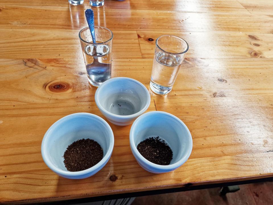
to sample the aroma, and then with added hot water (between 85 and 91°C, 190°F).

On the left is medium roast coffee and on the right, dark roast. If you watched the video above, you might have inferred that medium roast coffee is denser than dark roast coffee, as more gases inflate the dark roast beans in that extra minute of roasting. This can be seen just by dipping a spoon lightly into each sort


whereupon you can see that dark roast grounds tend to float more than medium roast grounds.
Having sniffed the dry grounds, we then sampled each coffee, trying to identify the various overtones that are available. The lighter the roast, the more floral or fruity the taste; the darker roast has less acidity but more bitterness. Paulo pointed us at a flavour chart in the (completely unfounded) expectation that it would help us

I could have told you it was coffee and that the two tasted different from each other; Jane got a bit further by identifying a couple of key tastes. But I’m as useless at such subtlety as I once discovered that I also was with wine. So it was interesting to note this level of nuance in the tasting of coffee, but Paulo gave us the most important rule:
The best coffee is… the one you like.
The way coffee is ground (coarse, medium, fine), the way it’s prepared (drip, French press, espresso machine) and the amount it’s roasted (light, medium, dark) all affect the final product. Like wine or music there is no good or bad, simply what you like or don’t.
There were some nice decorative touches in the mill

Traditional coffee transport – ox-cart

Various grinding solutions
and outside there were racks for drying beans in the sun.

Rosa Blanca do fully-washed and other processes – fermented, honey, natural, as shown by the colour of the beans.

Left to right – Fermented, Natural, Honey, Fully-washed
All in all, it was another absorbing, educational and intense education session for us about the intricacies of coffee. We walked back to the hotel, where another cup of coffee was made for us, to round off the experience, whereupon we retreated to our apartment to mull over what we’d learned (and I tried to write it up before I forgot all the stuff that I’d just been told).
So.
This has brought you up to date. I sit here, typing in the present tense after a late lunch and we now start preparing for our departure from Costa Rica tomorrow, because this was our last call on our 13-stop itinerary around an extraordinary country.
It has been extraordinary.
In 31 days, I’ve taken a smidge over 4,000 photos on my Big Camera, and 1,300 photos and 200 videos on my phone. Jane has recorded over 1,400 photo and 65 videos on her phone. 200GB of content. Thank you, Nikon and Samsung, for your help with the quantity. It has been a pleasure seeking the wheat from amongst the very considerable amount of chaff, and dressing it up so you can read about the many wonderful things we’ve seen whilst we’ve been here; thank you for accompanying us as we’ve stumbled from place to place.
Our taxi arrives to take us to the airport at – oh, fucking hell! – 0515 tomorrow. I shall try to pull together some valedictory thoughts over the next couple of days to close off this section of this blog. In the meantime…
Thank you. Thank you for reading my blog.


