Tag Archives: Sarria

Camino Day 35 – Sarria to Portomarin: Surrounded By The Madding Crowd

Saturday 23 September 2023 – Today was a trying day. I shall be moaning a lot about it in this post. If you’d prefer to avoid my self-pitying querulousness, you can simply see the summary video on Relive.

The weather forecast for today was fine – sunny and not too hot. The only worry on my mind was how crowded would the trail be. To remind you, Sarria is significant because it’s just over the 100km away from Santiago needed to qualify for a Certificate or Compostela when arriving there. Therefore, a lot of people start their Camino in Sarria.

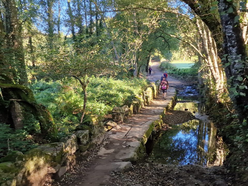
On turning the first corner, the situation became clear

and my heart sank. For five weeks, Jane and I have been walking effectively in solitude and we were suddenly confronted with what seemed like masses of people. Of course, it wasn’t a crowd, but the sharp contrast with not only the walking we’ve done in Spain, but actually all the walking we have done, in England and elsewhere, made me feel very uncomfortable. Yes, of course these people have a perfect right to be there; of course I’m being unreasonable. But I hated it. All day. I even found myself at a couple of points thinking, “Well, I’ve proved I can do the hills; I’ve proved I can do the miles, why should I put up with this? Why not just grab a taxi and spend a few extra, relaxing days in Santiago?”

Annoyingly, it even affected my photography. Over the last weeks, I have taken a measure of care over the photos I’ve taken, spending time composing the image and capturing it as best I can on a (top notch) mobile phone. This takes time, perhaps as much as 30 seconds. In that time, the people that I’ve overtaken would have passed me, and so I would have to suffer the Very British Problem of feeling embarrassed when I overtake again. And again. And again, My defensive response was either not to bother taking photos at all, or just to grab a shot as I walked along and hope that it was OK. This doesn’t always work, as this one I tried to take of a chap opportunistically selling pilgrim sticks shows;

it’s blurred and badly framed. In others, there are people in the frame when I don’t want them there, or I’m not happy with the composition. The day was as trying photographically as it was emotionally.

There was scarcely an instant in the day when Jane and I had any feeling of being by ourselves.

In many respects, the day was a good one: the weather was perfect for walking; the going underfoot was very good; and the scenery was, at times, lovely.

We were passing through farmland, and so there were (scents to smell and) animals to see.

There were charming vignettes, such as this family weeding their land,

a new take on a pilgrim mural,

and attractive building decoration.

There were stops for coffee and beer.

There was uphill and down dale (much more, to be frank, than I expected, but it was nice to get the exercise). There were attractive corners of the many villages we passed through.

There were unusual objects, some familiar, such as this dovecote

and some less so: does anyone know what these are for?

We think they’re stores of some description, but if you know, please post a comment to educate us.

There was a very significant waymark,

although, as I’ve said earlier, its precision in specifying exactly 100km to the nearest metre as the remaining distance is bound to be inaccurate. I don’t care, and neither did all of the other people taking their photos and (sigh) selfies around it.

There were bridges, some very modest

some with a little more presence, albeit somewhat rough

and some really grand ones

which brings me to our destination, Portmeirion Portomarin.

Believe it or not, there was a steep descent to get down to that high bridge. Amazingly, there was a decision point on the trail beforehand

where everybody turned right, because turning left (on a more recently-crafted route) carried with it a warning that it was steep. Given how steep the “not-steep” route actually was, I can only imagine that the other route required pitons and ropes. Quite why it was put in place, I don’t know. Whatever, the route we took led you past a couple of great viewpoints to see the very impressive bridge across a river that has been widened by a dam somewhere downstream (which, incidentally, required the entire town of Portomarin to be relocated in the 1960s). Amazingly, people were walking past this viewpoint without even registering it, far less to take a photo or (shudder) a selfie. Why do all this walking and ignore what’s around you?

Anyhoo…

The bridge offers some great photo opportunities as you cross it

and when you get to the other side you are greeted by a significant flight of steps;

only 46 steps, actually, so not as bad as getting into Sarria, where there is a flight of 62 to keep your heart rate up.

Although there’s not a huge amount to see in Portomarin, it’s a handsome place

with a very large and historically significant church at its centre.

Portomarín was a town of great importance during the Middle Ages – appearing in the Codex Calixtinus – because Its bridge was a strategic crossing point, as it was the only place where it was possible to cross the fast-flowing Miño River without a boat. The church of San Nicolao, was actualy moved, stone by stone, from its original location when the river was widened. It is an unusual combination of a church and a fortress. This twofold purpose originated with the Order of Knights of the Hospital of St. John of Jerusalem, who built it between the late 12th century and the early 13th century to provide protection for pilgrims and traders.

Inside it’s plain, but otherwise fairly churchy.

At each end there is a modern stained glass window. The one you can see in the photo above is fairly unique in that it has actually 13 segments (the norm is 12; sometimes you see 10 or 16). We have failed to find out why this is the case.

Inside the church are a couple of photos of Dom Sampedro

(you remember – the chap who is largely responsible for the reinvigoration of the Camino) and outside there are a couple of statues, including the obligatory one of St. James.

Our hotel is literally in the shadow of the church (well, after midday it is) and it has a kitchen with a fridge, a kettle and mugs, so we can make ourselves lashings of Twining’s finest Earl Grey tea.

And this brings my story of the day to an end. I would say I’m sorry for the moaning, but I’m not. I only hope that I can come to terms with the extra numbers of people on the trail. One friend suggests leaving late and walking slowly so that the hordes are largely dispersed; perhaps we’ll try that. In any case you’ll be agog to know the latest stats, won’t you? We covered exactly 23km today, which means that I don’t need recourse to a calculator to tell you that our total is now 713.4km. I do need one to tell you that this is just over 443 miles.

Tomorrow, our destination is Lestedo,, which is about 20km away. Once again, rain doesn’t figure anywhere in the Accuweather forecast; let’s hope that they get tomorrow as right as they got today, and I’ll bring you news of the day’s events, hopefully in a more positive tone, in due course. For now, hasta luego!

Camino Day 34 – Triacastela to Sarria: Going to the Dogs

Friday 22 September 2023 – Today was a day of inaccurate expectations.

The Accuweather forecast for today was very discouraging. Previously, if the chance of precipitation was around 50%, it might have predicted “Cloud”, or “Intermittent Cloud”. Today, for each of the relevant locations for the day – Triacastela, Samos and Sarria – it forecast, baldly, “Rain”. Given that much of the day’s walking would be on trails rather than roads, I was sorely tempted to wear walking shoes rather than the tried-and-trusted socks and sandals. Before we went to breakfast, I looked outside and it was dry, so I trusted to luck and donned sandals.

As we ate breakfast, it started to rain. Of course it did.

However, I decided to stick with sandals. We donned rain jackets and rain covers for the backpacks and started off at about 0830 into persistent, but not overly heavy, rain.

There were, broadly, two options for the day – going via the Samos monastery, or taking the direct route. We decided to stick with plan A and head for Samos, on the basis that 25km across country in the rain was probably less dispiriting than 16km grinding along beside a road. You can see the Relive video summary of the day here if you haven’t time to read on.

Quite soon after we set out, the rain, to my surprise, eased, then stopped altogether – the first of my expectations unfounded.

We spent the first few kilometres walking beside the road

on a track that was well-maintained for the most part.

After about 3km, we departed the road and struck out across country, coming to the first of the many (largely deserted and somewhat crumbling) villages that we’d pass through in the day – San Cristovo do Real.

Our path was good underfoot, and the weather persisted in not raining.

We walked through Renche,

which had some interesting roof tiling on some of its properties.

We were particularly struck by the “dragon’s back” effect achieved with the slates; dwellings in some of the other villages had a similar approach, so it would seem to be something of a local architectural vernacular. There was a lot of slate in the ground as we walked the paths, which made its choice as roofing material quite logical.

A possible coffee stop in Renche proved to be closed, despite the protestations of the owner on Google Maps. We used his tables and chairs, though, to park our backpacks whilst we took off the fleeces we had on under our rain jackets, as we were getting quite warm. This was as the result of a second expectation of mine which proved to be inaccurate – the terrain. The route, according to Garmin, had this profile.

I had expected a drop of 270m over a distance of 25km to be a gentle downward stroll; as Google might call it, “largely flat”.

It wasn’t. It reminded us of something we’d come across in our travels in South America. In Peru, where the Incas held sway for so long, there is a terrain description: “Inca flat”. Given the Incas’ predilection for building large and complicated structures up mountains, it should come as no surprise to learn that what they considered flat going was, well, not. And so it was with out path today – Inca Flat, with some surprisingly steep uppy and downy bits. However, the weather was kind to us and the going underfoot was largely fine, so it was a pleasure to make our way, and we were really glad that we’d stuck with the longer trail after all.

San Martiño do Real was the next village we passed through,

and shortly after we reached a place proudly advertising itself on Google Maps as the “Mirador de Samos”. We had high expectations of getting a really good view of the fabled monastery of Samos, Mosteiro de San Xulián.

Well, I suppose it’s a decent overview, but it would help if someone chopped a few of those trees down, don’t you think?

We walked the tortuous route into Samos and found a coffee stop – very welcome after 10 coffee-less kilometres – which also gave us a very nice view of the monastery.

As we sipped our coffee and snarfed our croissants, we made plans about just having a quick look around the monastery, as we wanted to crack on with the walk while the weather was good rather than investing time waiting for and going on a guided tour.

Another expectation shot down. You can only enter the monastery as part of a guided tour; we’d just missed one, so would have to wait the better part of an hour before a 40-minute tour. Probably in Foreign, at that. So we took a photo of the (admittedly impressive) frontage,

got an equally impressive stamp on our credentiales, and decided to move on, whilst, as I say, the weather was good.

About half a kilometre further on, it started raining.

We took shelter under some trees and waited a few minutes, and, fortunately, the rain eased, so we carried on.

Very shortly we came to Foxos,

which has a squash court.

We were walking between the road and the Rio Sarria at this point, and the river gave us some nice scenes such as this.

At this stage we were somewhat part of a procession of pilgrims, but we had a trick up our sleeves, ha, hah! Whereas the official track simply headed off directly to Sarria, walking some 10km beside the road, both the Brierley book and the good folks at WalkTheCamino.com had provided an optional route.

and so while everyone else carried straight on, we hung a right

and walked to start with along a stretch of road. I suspect we could have stayed on the road, but the Black Line on our Google Map took us (decidedly) off piste,

past (crumbling) farm buildings,

some nice views

through a village called Gorolfe

to the village of Sivil and a very bizarre sight – a scenario of what looked like cattle pulling an ox-cart.

It turned out to be in the garden of a (somewhat bonkers) Pensión called A Fonte das Bodas.

Bonkers or not, beer and coffee were on offer, and so we settled down outside to watch the fun as the lady who managed it bantered with her various guests.

It will take a while before I forgive the group you see in the photo above. During the banter, we heard that they were from Taiwan. My brain leaped upon this and so for the whole of the rest of the walk, I had the 1973 earworm from a group called Dawn: “Taiwan Yellow Ribbon Round The Old Oak Tree”. Well, I suppose it made a change from the Funeral March from Beethoven’s Eroica Symphony which had accompanied my huffing and puffing up the slopes earlier in the day. I despair at the musical antics of my brain, I really do.

We were nearing Sarria by this stage; just one village to go.

This one was called

and nominative determinism ruled:

“Perros” is Spanish for “Dogs”.

We rejoined the “direct” Camino route, walking along beside the road

and very soon caught sight of Sarria in the distance.

The rest of the walk was a matter of working our way through the outskirts,

climbing 62 steps, called “A Escaleira da fonte”

and making our way past a church with an atmospheric mural

through the town

to our hotel.

We checked in and had a very briskly-dispensed lunch before having a quick wander around to see the sights of Sarria. It’s a quick wander because there aren’t many that we hadn’t already passed: a ruined castle;

a mirador which, to be brutally frank, is even more tree-infested than the Samos one;

an early 20th-century prison building, now an exhibition space;

The Other Church;

and a couple of nice decorative touches.

And that was it, so we had the rest of the day to ourselves, to relax and plan for the morrow.

Sarria has an important part to play in Camino Lore, as it’s just over 100km away from Santiago. Anyone wishing to get the prized Certificate of Distance or Compostela on arrival in Santiago must be able to show that they have travelled at least 100km and got two stamps in their Credenciales each day from places along the way. This means that there are a lot of people starting from Sarria; the people checking in before us at the hotel were prime examples, since they had clearly just arrived in Spain and didn’t actually know how to find or follow the Camino. The receptionist patiently explained about following the yellow arrows and the crowds.

The crowds: this is likely to be a challenge for Jane and me to moan about rise to. Over the last 400+ miles we’ve relished the experience of being largely alone as we walk, almost resenting the presence of other pilgrims. I wonder how we’ll feel with crowds of “bloody amateurs getting in our way.”

The Brierley book cautions against such a patronising attitude; everyone has a right to enjoy the Camino in their own way, and I hope that we can stay positive as we wend our way Santiago-wards.

Today’s stats: Relive credits us with 26.2km, so we have now covered 690.4km, which is 429 miles.

Tomorrow, our destination will be Portomarin, about 22km down the (crowded) road. The weather forecast is, as far as we can tell, good; let’s hope that Accuweather has got things right about that, so that we can stay positive as we elbow our way through the throng. Check back in soon and you’ll find out how we got on.