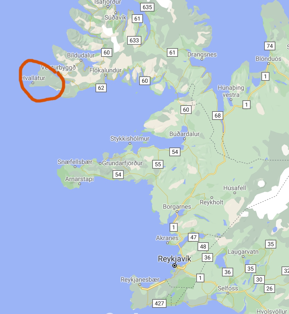
Tag Archives: Landscapes

Day 12 – Yes, We Canyon!

Saturday 10th July 2021. One loses track of time on an excursion such as ours. It was something of a jolt to realise that it was the weekend, at least for everyone else; we just carried on in our little dream world as we explored the southern region of Iceland before joining the “Golden Circle” route tomorrow. And, probably, hordes of bloody tourists.  We’re now within range of day trips from Reykjavik, and it showed in the number of punters and the number of coaches at the various places we stopped for a gawp.

The first of these was yet another Interesting Church, this one on the site of a medieval convent at Kirkjubæjarklaustur, very near our hotel.

Like almost every Interesting Church we’ve come across, it was closed, and I have yet to hear a credible explanation of how come there are all these churches which seem almost universally to be unused on any kind of a regular basis.  Is there a vicar or priest? Is that person a visiting official? Who pays for the upkeep? etc, etc. Anyway, it’s lovely to see such interesting church designs; and this one is not the last of this trip.

The next place we went to has to be one of the most arresting sights of our holiday in Iceland. It’s called Fjaðrárgljúfur and is billed as a canyon.  As you approach it, you begin to get some idea of what awaits.

Then you look carefully and you can just make out a couple of sheep as the merest dots (just left of centre in this picture)

and then you climb to the observation platform and see this

This was the first Shot Of The Day. It is a truly awesome sight, without being completely overwhelming (like, say, the Grand Canyon is).  A remarkable start to our day. You can walk down towards the other end, passing some sheep

(one was sleeping and we hope it didn’t really drop off) and have a look from there.

There’s a figure on the right bank as we look along it from here, and that gives some idea of scale.

We next got a chance to see a couple of uniquely Icelandic things.  The first was a sheep rounding circle.

There are half a million sheep in Iceland – more than the number of resident people – and they are basically free to roam.  This means that you can come across them almost anywhere, sometimes, alarmingly, in the middle of the road as you drive along.  Somehow (by horse, dog, 4×4, anything that works), every September these wandering sheep are rounded up from wherever they’ve got to, a convulsive effort over around three days which is a massive part of Iceland’s culture and something that all farmers have to join in on.  The sheep are herded into the central pen and then individual farmers pick out their sheep (they all have ear markings) and separate them into that farmer’s segment.

The second insight came as we got a chance to try to grasp the impact of an enormous event in Iceland’s – and indeed the world’s – history – the Laki Eruption of 1783-5.  This was of staggering size and impact: an outpouring of an estimated 42 billion tons or 14 km3 (3.4 cu mi) of basalt lava and clouds of poisonous hydrofluoric acid and sulfur dioxide compounds that contaminated the soil, leading to the death of over 50% of Iceland’s livestock population, and the destruction of the vast majority of all crops. This led to a famine which then killed approximately 25% of the island’s human population. The lava flows also destroyed 20 villages. The eruption and its aftermath caused a drop in global temperatures, as 120 million tons of sulfur dioxide was spewed into the Northern Hemisphere. This caused crop failures in Europe and may have caused droughts in North Africa and India.

We stopped in the middle of the huge lava field resulting from this eruption.  It’s difficult to convey the scale of it – kilometre after kilometre of moss-covered lava, because only moss – nothing else – will grow on lava, and this takes centuries to develop.

I created a Facebook 3D photo which might help to underline the scale of this.

Our next port of call was what Dagur called the “Yoda Cave” – actually used as the setting at the star of Star Wars – Rogue One, as the cave our heroine dashes into to escape from some band  or other of marauding riffs.

It looks quite impressive from the inside as well.

This is in a part of Iceland that used to be an island, but the volcanic actions raised the land up around it.

This is close to a town called Vik, which has an Interesting Church, more for its location than its architecture.

In the distance to the left can be seen the “Three Trolls”, Reynisdrangar, rocky outcrops off the beach, Reynisfjara. You can get a closer view of them from Vik’s black sand beach.

We headed over towards them and I guess this was the first time we came across hordes of tourists – Reynisfjara is a popular spot and the car park was crowded. There are a couple of lava caves

one of which has basalt columns by it – popular for kids to climb on.

We carried on along the coast a short way, stopping at the clifftop at Dyrhólaey, which has a view over an impressive rock arch

as well as the surrounding countryside

it’s own troll

and – delightfully –

puffins!  Dagur explained that these are often blown over from their usual colony to the east during August.  The fact that some are here at this time of year, and that they appear to have burrows that they are using, implies that this is becoming an established puffin colony in its own right.  I took loads of pics, obvs, and even nearly managed an in-focus one of a puffin flying off.

But the wind was gale force and so hanging about to try to get a better photo was not a comfortable option. We moved on.

The southern region is marked out, as I posted yesterday, by glaciers and the road to our next major stop offered a chance to get a nice picture of one of them – an offshoot of Vatnajökull, but I don’t know which one, I’m afraid.

The rest of the day was almost exclusively about waterfalls, which was a relief.  It’s been ages since we saw a decent waterfall and I was beginning to get withdrawal symptoms.  Our next stop, then, was at Skógafoss, but we were hungry so stopped for lunch at the hotel there before exploring the waterfall itself.

And it’s a splendid sight.  The car park was crowded, as was the shoreline, with lots of people getting in each other’s way as everyone tried to get fucking selfies, which always enrages me. Mind you, I did manage to get something out of other people’s cavorting.

By aggressive use of sharp elbows, I got to the front where I had a few seconds to get a view of the falls unsullied by tourist vapidity. But actually, the second Shot Of The Day came about as a girl walked in even further through the spray towards the falls and gifted me with the perfect shot.

Before the next waterfall, we stopped briefly to view some turf houses in a place called Drangshlíð.

I found this post about them on the web, but it didn’t really leave me any the wiser.

A few kilometres along the road we stopped at Seljalandsfoss, which is another great sight.

It’s very popular, as it’s a waterfall you can actually walk behind

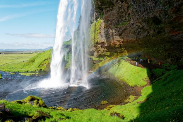
after having done which, you can walk along to another one, called Gljufrabui.


View this post on Instagram


A post shared by Steve Walker (@spwalker2016)


And that was nearly it for the day’s interesting bits.  We are staying the night in the Sel Guesthouse near Skalholt, and it is a charming place.  Though the charm is somewhat rustic, it has WiFi and other mod cons, geothermal hot water in the bathroom, but no restaurant.  So we made our way to the Farmhotel Efstidalur, which really is a working farm.  From the cafe, you can see the cows

and upstairs in the restaurant you can eat them.  We had a pulled beef salad which was absolutely delicious.  Then we indulged ourselves with some of their home-made ice cream downstairs.

Thus ended our day. We will be Doing The Golden Circle tomorrow, with the major tourist sites and sights that this offers. It should be a good day, and it’s our last day on this tour, so let’s hope for a final Grand Day Out. Please check in tomorrow to see what actually happened, why don’t you?

Day 3 – Flipping birds!

Thursday 1st July 2021. Another Long Read Alert – lots of pictures again!

For a holiday such as this, where sightseeing and photography are basically the whole point of the exercise, the weather is anything from important to critical.  This makes Iceland a place of great uncertainty, since it’s basically impossible to have any confidence in what the weather gods will bring.  So, the morning ritual of opening the blinds to peep out at the weather is a time of heightened tension.  This morning?

Not too bad, it would seem.  Not that this is a guarantee, or anything, but at least we know it’s not hurling it down for the moment.

After breakfast we set off for various destinations around the area, the southernmost bit of the West Fjords.

Off we went, and it soon became clear that the promise of a sunny day was an empty one.

I mean, it’s a nice view and all, but suddenly the horizon’s gone.  Near this spot is a bizarre statue.

It is of Julius Oskar Þorðarson, who was apparently the boss in charge of the gang who built the road it stands on, back in 1947.

A few kilometres on the scene cleared a bit, so we got a good view of the road to Patreksfjörður. Slightly to the side of that was an appealing optical illusion.

The trees look like a pine forest until you realise that the blue patches are the ubiquitous lupins, at which point it becomes clear that the trees are less than 2 metres tall. (There are very few tall trees in Iceland because of the paucity of much of the soil and the relentless strength of the wind; the only ones you’ll see  are imported and sufficiently short that wind doesn’t tear them to shreds. Hence the local joke: what do you do if you are lost in a forest in Iceland? Stand up…)

Patreksfjörður is an appealing town, which, like so many in this area, is located on crammed into a thin strip of land between the sea and a thundering great mountain.

The locals are building a wall to keep out the avalanches which are a constant possible threat. You might be able to make out the earthworks in the centre of the picture, above the buildings.

The town centre has some handsome buildings

and it’s generally an agreeable place.

We then moved on towards the hotel where we were to stay the night, the Hotel Latrabjarg. En route we passed a rather bizarre sight.

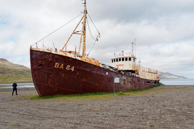
This is the not-so-good ship Garðar, billed as the oldest steel ship in Iceland, built in 1912 and now abandoned here to rot. No, me neither.

However, just by the wreck was the rare occurrence of a stretch of water unruffled by wind, which gave me the opportunity to indulge my favourite sort of landscape photo, a reflection.

There was uncertainty about whether our overnight hotel would be able to offer us dinner*. In the end, we decided to eat somewhat down the road and so planned lunch in Breidavik, with a further plan to return there for a sufficiently early dinner to allow for an activity which was best planned for the evening.

Before lunch, we went to the beach.  Of course we did.

On the southern extremes of this peninsula is an area called Rauðisandur, “Red Sands”.  It’s not really red, but actually, well, sand-coloured.  But nonetheless it felt extremely out of keeping with a holiday among glaciers and mountains, to go to a vast expanse of sand.

So, the mountains stop and the sand starts.

and the “beach” is actually a sand spit with water inland of it.  But it still feels like you’re on the beach.

Dagur, in chasing a particular photographic angle, did his Cnut act

and was just as successful, ending up with boots full of seawater.  I don’t know if he got his shot or not, actually.

The water inland of the sand gives an opportunity for some interesting shots

and in places you can see that the sand is not all sand-coloured.

One has to walk a short distance to get from the car park to the sand, and the walk, and an episode on the way to lunch, gave me slight pause.  As you head towards the sand, you pass a really lovely view.


I couldn’t walk past that without stopping to admire it, and of course take a photo. Dagur walked past it without a glance.  Shortly after we left the sands, we asked him to stop so we could take photos of no fewer than three waterfalls visible from the same spot.

Dagur, again, hadn’t really thought about stopping for it.  He’s so used to the fantastic sights that you can see in Iceland that he doesn’t see small fry like these scenes, whereas to us Brits, they’re fascinating and lovely.

After lunch we drove to the other end of the sand spit for a walk around.  It turned out that the walk took us past the nesting grounds of some Arctic Terns, who were not best pleased to see us, and so started dive bombing us.  They’re very agile flyers, and so it’s disconcerting to have them head straight for you, only to veer away at the last instant (or even peck at your head en passant, apparently).  From several dozen attempts, I managed to get a couple of halfway decent pictures of a tern in flight.

There was a lot of bird activity.  In a little stream nearby was a little chap we think is a Dipper (though not a big one).

and the skies were filled with the sights and sounds of dozens of different types of birds coming and going.

Near where we parked for this walk was a cute little black church

with Oyster Catchers on the surrounding wall.

They got rather agitated as we approached and we think they probably had a nest in the wall.  So we left them to it and headed to our hotel. We had a chance for a refreshing cuppa before heading out to an early dinner.

The reason for eating betimes was that we wanted to get to the Latrabjarg cliffs to see

the puffins, which are nesting at this time of year and which come out in the evening after a day in their burrows.

It’s a popular spot with photographers

and, to be fair, it’s a rewarding time to be out chasing photos.  The puffins are very cute and don’t seem at all fazed by having people thrusting long lenses at them.  It’s quite easy to get good photos, and I even managed some video.

We actually made two visits to the Latrabjarg cliffs, with the later one being fractionally more satisfying.  In between times, Dagur whisked us off to an area called Keflavik (same name as the airport, rather different scenery).

It’s actually past the end of of the sands where we birdwalked, and down a very rough road (as you can see above).  You get a nice view, though, and it’s so difficult to get to that very few people will have seen it from this viewpoint.

It’s a Wild And Lonely Place (WALP Factor 8).

and Dagur also took us to see a monument to an extraordinary rescue attempt by Icelandic farmers of English sailors who were shipwrecked nearby, back in 1947. The farmers had to carry loads of gear out to this WALP and haul sailors up the cliff in very difficult circumstances – a major effort to save a dozen lives.

(I think the weather’s always foggy here, which is probably why the ship was wrecked.)

The day today had featured a lot of avian activity with some very satisfying results.  I think that tomorrow will involve longer periods in the car spent travelling around, so maybe tomorrow’s enthralling episode will be shorter.  There’s only one way to find out, so see you then, I hope.


* In this part of Iceland, towns are small and far apart, and often only accessible by unsurfaced roads. Generally speaking, it’s a Wild And Lonely Place, so you can’t make any assumptions about whether anything is still open or offering what one might think of as a normal service. On entering the Latrabjarg peninsula, for example, there’s a sign informing you that there are no fuel stations in that part of the island.  As it happened, the Latrabjarg hotel could provide food, but not early enough for our purposes.

Oman Day 8 – Muscat Ramble

Thursday 28 Feb. We spent the morning with Rashid, who took us to see some of the highlights of Muscat before lunch. We certainly packed it in – Grand Mosque, Opera House, Souq, Sultan’s Palace, National Museum. I took loads of photos, but really feel that I need to get to a PC to tweak them to do the sights justice. Here are a few, and I will come back and update them with improved versions once I can get my hands on decent RAW processing software.

The first item on the itinerary was the Grand Mosque, a gift to the people of Oman from Sultan Qaboos, with the intention of spreading a clear message of inclusive and peaceful Islam. It’s an impressive building, certainly on a par with the Sheikh Zayeed Mosque in Abu Dhabi, Through a knowledgeable and impassioned exposition of information about the mosque, Rashid also showed that he has a serious and thoughtful approach to his Ibadi Islam religion. (Ibadism, a school of Islam pre-dating Sunni and Shia denominations, is dominant in Oman and is noted for its realism, tolerance and preference for solving differences through dignity and reason, rather than confrontation).

I could drown you with photos and information, but I’ll try to include just the bare essentials and will set up a full Flickr page on the mosque in due course.

Right from the first approach, you get the sense that the building is intended to inspire awe and devotion. It combines places of worship (white marble) with places of enquiry, scholarship and administration (pink marble).

The Grand Mosque, Muscat

As you approach the central hall, there are many impressive views of the buildings.

The Grand Mosque, Muscat

The Grand Mosque, Muscat

The Grand Mosque, Muscat

Before entering the main hall, Rashid showed us that this is also a place of learning and scholarship. An impressive door leads into a library

Inside the Library

where people may read, study and learn. There are also imams on the site who will give guidance to anyone who asks for help.

Then we entered the main hall of prayer, which is hugely impressive. It really is difficult to convey this in photos. Here’s an overall impression

and here are some other highlights as you walk around: A vast carpet, hand stitched in Iran by (I think) 43 women over four years, and valued at around 10 million pounds

Prayer Hall carpet

(interestingly, it has no lines in it to instruct worshippers how to line up – the Abu Dhabi mosque does – but apparently they line up OK anyway. See later for more lines). The detailing all around is very intricate and beautifully done

Prayer Hall - ceiling detail

and there are detailed carvings and mosaics all around the walls. Some are functional – this contains copies of the Quran

Niche inside Prayer Hall

some are decorative

Here’s a set of individual Quran chapters laid out in a niche.

and here’s a view of the central dome and massive (Austrian crystal) chandelier.

Prayer Hall - chandelier and carpet

Outside the main hall of worship are several courtyards where worshippers can find a place when the main hall is full.

The Grand Mosque, Muscat

In the above photo you can also see carved script running around the walls; the entire Quran is written in the fabric of the buildings – albeit in a highly caligraphic style which is difficult to read, apparently.

The lines you see in these courtyards are lines along which (male only) worshippers stand and kneel to pray. The number of courtyards with these lines in really underlines that the mosque can accommodate a huge number of worshippers, the vast majority of whom will be male.

Females are by no means excluded, oh, no, absolutely not. Here is the hall where women can worship.

Women's Prayer Hall

As you can see it’s much smaller than the spaces reserved for male worshippers. This is because it is apparently OK for women to pray at home, but men have a duty to attend a mosque to pray if they can. Women pray separately from men in order that the men don’t lose focus on the act of worship by catching sight of a fetching female, albeit one wrapped up in a scarf.

For a fan of architectural photography such as myself, there are many opportunities for striking photos.

The Grand Mosque, Muscat

The Grand Mosque, Muscat

We left the mosque with one final view

The Grand Mosque, Muscat

before heading to our next stop – the Opera House. This is a pretty monumental slab of architecture – modern because recently built (at the behest of the Sultan, who was educated in England and acquired a taste for opera there, poor sap).

The Royal Opera House, Muscat

Inside is, as you’d expect, very nicely done, with a posh ticket hall leading to the auditorium.

Ticket Office, Inside the Royal Opera House, Muscat

(on the extreme left you can see the security scanner whch prompted the nice guard chappie there to relieve me of my Swiss army knife for the duration of our visit, just in case I had considered running amok with it). The auditorium itself is large but not huge – a capacity of 1,100 poor unfortunates – and with a very large royal box (not a surprise, given whose idea the building was).

It’s all very comfortable, with screens in the back of each seat showing the translations which are so critical when trying to make some kind of sense of the ludicrous plots that are unfolding before you.

You may have guessed that I don’t like opera, and you’d be right. It’s the singing that I hate, mainly. In fairness the auditorium is also used for ballet, orchestral, local and international song and theatre productions…

Anyhoo – our next stop was the Souq – Muscat Souq is in an area of the town called Mutrah. Jane was looking for some of the kind of glass receptacles that were used on our camp majlis tables:

and we thought, of course, “Souq and ye shall find”. So we souqht, among the many colourful boutiques:

Muscat Souq Scene

Muscat Souq Scene

and were offered many, many opportunities to buy all sorts of things, but mainly Kashmiri cloth and incense; but the requisite glassware was not around, although there were some other nice scenes.

Muscat Souq Scene

Muscat Souq Scene

Muscat Souq Scene

Most places were selling tourist tat, and so our occidental appearance was very much grist to the mill of the local importunate selling technique. We just said “shukran” (meaning literally “thank you” but in this context “no, thank you” and eventually escaped so that we could visit our next stop, the fortifications and Sultan’s palace on the outskirts of Muscat.

The Royal Palace is stylistically a bit off the mainstream in my humble opinion – it looks more like something that Gaudi might have dreamt up.

Royal Palace, Muscat

Overlooking it is Al Mirani Fort, one of a pair of ancient forts guarding Muscat from those marauding Riffs from Nizwa (the other is called Al Jalali and is across the harbour from Al Mirani).

Al Mirani Fort, Muscat

As you look away from the Royal Palace, you see a monumental street with monumental buildings and, at the end of it, the National Museum.

National Museum, Muscat, Oman

I’m not normally a great one for museums and my back and feet were aching for some respite – lunch, say; but in we went. The museum is not vast but the scope of its exhibits is, covering Oman’s prehistory and history, renaissance, relationships with the world, Islam, heritage, maritime history and the land and the people. There’s an airy central atrium

with lots of exhibition halls going off it. Some things were very striking, such as the relief map of an irrigation system from mother well, through habitations and finally to the plantations

Sample irrigation plan

which, if you look closely, is beautifully done in layered wood to show the contours.

Sample irrigation plan

Another such relief map illustrates clearly how Muscat nestles among mountains.

Muscat Harbour relief in wood and photo

We also found an exhibit hall dedicated to the “beehive tombs”

and a selection of very imposing gates such as this one

which was made in 1126 and guarded the entrance to ash-Shibak fort. If you look closely, you can see the UK Royal Coat of Arms among the other calligraphic, floral and animal motifs. It reflects the close ties between Oman and the British East India Company in the time of the Mughals.

After such a sprint round the tourist boxes-to-be-ticked, we were ready for a break, and Rashid took us to the Turkish House for a seafood meal – wonderfully grilled prawns and some sort of snapper, accompanied by calamari, hummus, a spinach salad and some wonderful flatbread – a nice way to round off the day’s touristing.

By the time we’d finished lunch (around 2.30pm) the traffic had really built up, as this was a Thursday and therefore people were heading out for the weekend. So it was a bit of a grind to get back to the hotel, but we made it in time for (complimentary) afternoon tea followed by (complimentary) G&T and an opportunity for me to update the blog. We have one more day in Muscat and you’ll simply have to read the next instalment to find out how that went.