Saturday 10th July 2021. One loses track of time on an excursion such as ours. It was something of a jolt to realise that it was the weekend, at least for everyone else; we just carried on in our little dream world as we explored the southern region of Iceland before joining the “Golden Circle” route tomorrow. And, probably, hordes of bloody tourists. We’re now within range of day trips from Reykjavik, and it showed in the number of punters and the number of coaches at the various places we stopped for a gawp.
The first of these was yet another Interesting Church, this one on the site of a medieval convent at Kirkjubæjarklaustur, very near our hotel.

Like almost every Interesting Church we’ve come across, it was closed, and I have yet to hear a credible explanation of how come there are all these churches which seem almost universally to be unused on any kind of a regular basis. Is there a vicar or priest? Is that person a visiting official? Who pays for the upkeep? etc, etc. Anyway, it’s lovely to see such interesting church designs; and this one is not the last of this trip.
The next place we went to has to be one of the most arresting sights of our holiday in Iceland. It’s called Fjaðrárgljúfur and is billed as a canyon. As you approach it, you begin to get some idea of what awaits.

Then you look carefully and you can just make out a couple of sheep as the merest dots (just left of centre in this picture)

and then you climb to the observation platform and see this

This was the first Shot Of The Day. It is a truly awesome sight, without being completely overwhelming (like, say, the Grand Canyon is). A remarkable start to our day. You can walk down towards the other end, passing some sheep

(one was sleeping and we hope it didn’t really drop off) and have a look from there.

There’s a figure on the right bank as we look along it from here, and that gives some idea of scale.
We next got a chance to see a couple of uniquely Icelandic things. The first was a sheep rounding circle.

There are half a million sheep in Iceland – more than the number of resident people – and they are basically free to roam. This means that you can come across them almost anywhere, sometimes, alarmingly, in the middle of the road as you drive along. Somehow (by horse, dog, 4×4, anything that works), every September these wandering sheep are rounded up from wherever they’ve got to, a convulsive effort over around three days which is a massive part of Iceland’s culture and something that all farmers have to join in on. The sheep are herded into the central pen and then individual farmers pick out their sheep (they all have ear markings) and separate them into that farmer’s segment.
The second insight came as we got a chance to try to grasp the impact of an enormous event in Iceland’s – and indeed the world’s – history – the Laki Eruption of 1783-5. This was of staggering size and impact: an outpouring of an estimated 42 billion tons or 14 km3 (3.4 cu mi) of basalt lava and clouds of poisonous hydrofluoric acid and sulfur dioxide compounds that contaminated the soil, leading to the death of over 50% of Iceland’s livestock population, and the destruction of the vast majority of all crops. This led to a famine which then killed approximately 25% of the island’s human population. The lava flows also destroyed 20 villages. The eruption and its aftermath caused a drop in global temperatures, as 120 million tons of sulfur dioxide was spewed into the Northern Hemisphere. This caused crop failures in Europe and may have caused droughts in North Africa and India.
We stopped in the middle of the huge lava field resulting from this eruption. It’s difficult to convey the scale of it – kilometre after kilometre of moss-covered lava, because only moss – nothing else – will grow on lava, and this takes centuries to develop.

I created a Facebook 3D photo which might help to underline the scale of this.
Our next port of call was what Dagur called the “Yoda Cave” – actually used as the setting at the star of Star Wars – Rogue One, as the cave our heroine dashes into to escape from some band or other of marauding riffs.

It looks quite impressive from the inside as well.

This is in a part of Iceland that used to be an island, but the volcanic actions raised the land up around it.


This is close to a town called Vik, which has an Interesting Church, more for its location than its architecture.

In the distance to the left can be seen the “Three Trolls”, Reynisdrangar, rocky outcrops off the beach, Reynisfjara. You can get a closer view of them from Vik’s black sand beach.

We headed over towards them and I guess this was the first time we came across hordes of tourists – Reynisfjara is a popular spot and the car park was crowded. There are a couple of lava caves


one of which has basalt columns by it – popular for kids to climb on.

We carried on along the coast a short way, stopping at the clifftop at Dyrhólaey, which has a view over an impressive rock arch

as well as the surrounding countryside

it’s own troll

and – delightfully –

puffins! Dagur explained that these are often blown over from their usual colony to the east during August. The fact that some are here at this time of year, and that they appear to have burrows that they are using, implies that this is becoming an established puffin colony in its own right. I took loads of pics, obvs, and even nearly managed an in-focus one of a puffin flying off.

But the wind was gale force and so hanging about to try to get a better photo was not a comfortable option. We moved on.
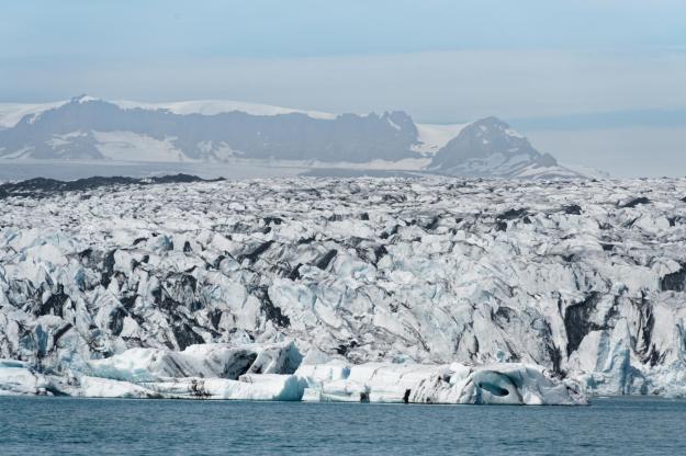
The southern region is marked out, as I posted yesterday, by glaciers and the road to our next major stop offered a chance to get a nice picture of one of them – an offshoot of Vatnajökull, but I don’t know which one, I’m afraid.

The rest of the day was almost exclusively about waterfalls, which was a relief. It’s been ages since we saw a decent waterfall and I was beginning to get withdrawal symptoms. Our next stop, then, was at Skógafoss, but we were hungry so stopped for lunch at the hotel there before exploring the waterfall itself.
And it’s a splendid sight. The car park was crowded, as was the shoreline, with lots of people getting in each other’s way as everyone tried to get fucking selfies, which always enrages me. Mind you, I did manage to get something out of other people’s cavorting.

By aggressive use of sharp elbows, I got to the front where I had a few seconds to get a view of the falls unsullied by tourist vapidity. But actually, the second Shot Of The Day came about as a girl walked in even further through the spray towards the falls and gifted me with the perfect shot.

Before the next waterfall, we stopped briefly to view some turf houses in a place called Drangshlíð.


I found this post about them on the web, but it didn’t really leave me any the wiser.
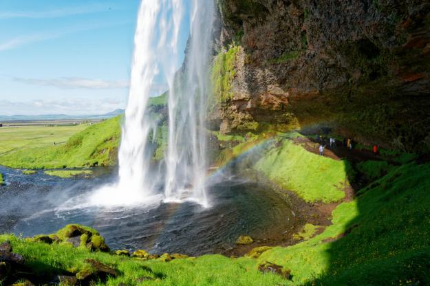
A few kilometres along the road we stopped at Seljalandsfoss, which is another great sight.

It’s very popular, as it’s a waterfall you can actually walk behind


after having done which, you can walk along to another one, called Gljufrabui.
View this post on Instagram
And that was nearly it for the day’s interesting bits. We are staying the night in the Sel Guesthouse near Skalholt, and it is a charming place. Though the charm is somewhat rustic, it has WiFi and other mod cons, geothermal hot water in the bathroom, but no restaurant. So we made our way to the Farmhotel Efstidalur, which really is a working farm. From the cafe, you can see the cows

and upstairs in the restaurant you can eat them. We had a pulled beef salad which was absolutely delicious. Then we indulged ourselves with some of their home-made ice cream downstairs.
Thus ended our day. We will be Doing The Golden Circle tomorrow, with the major tourist sites and sights that this offers. It should be a good day, and it’s our last day on this tour, so let’s hope for a final Grand Day Out. Please check in tomorrow to see what actually happened, why don’t you?


