Cami-flage Day 10 – Sunday 20th September 2020
Today’s walk was a short one – in Menorca we would only have been asked to cover just over 7 miles, and there is a handy equivalent not too far from us covering Ockham (hence the title) and Wisley Commons. It may be short, but it has several interesting and unusual features – read on to find out more.

The weather comparison between Surrey and Menorca is getting quite interesting.

It may be warmer Over There In The Foreign, but today and for the next couple of days we get the sun – and better temperatures for walking around, actually. Schadenfreude’R’us. Here’s hoping the gods of weather don’t take their revenge too swiftly….
Here’s an overview of the walk.

The roundabout in the middle top of the picture is Junction 10 of the M25, where it meets the A3. The walk straddles the A3 but stays south-west of the M25.
We started from the Ockham Bites caff, which advertises itself as selling award-winning Bacon Buttties; so we promised ourselves one for when we returned at the end of the walk.
The walk starts out over Chatley Heath, which is attractive enough,

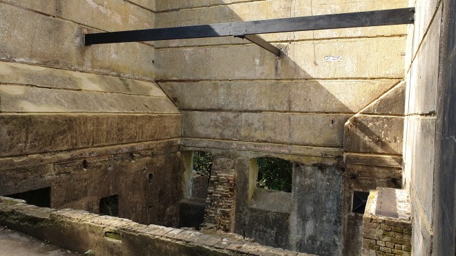
and was even more so earlier in the year when the heather was actually in flower. We soon reached the first landmark, which is the Chatley Heath Semaphore Tower, a unique remnant from the Napoleonic era, the only surviving semaphore tower in Britain. It was once a cutting-edge building at the forefront of technology and design, a vital link in a signalling chain that transmitted messages from Admiralty House in London to Portsmouth Docks in just a few minutes. But in recent years water ingress has been threatening the structural integrity of the tower to an alarming degree. When we visited recently, it was shrouded in tarpaulins as repair work was carried out; today, whilst it was clear that there was plenty of work going on, at least we could see most of this unusual building.

The path then moves into woodland, amongst which can be found several huge Redwood trees.

(you can just see Jane bottom right, which gives an idea of scale). As the trail moves on, the Teddy Bears’ Picnic line comes to mind: “If you go down to the woods today, you’re sure of a big surprise.” Between the trees you can start to make out an unusual object

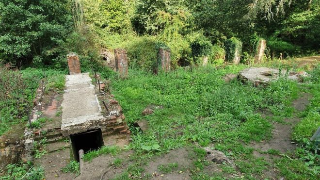
and, getting closer, you see a mausoleum, which is certainly a surprise finding to anyone covering the route for the first time.

This (according to an engraved plaque) houses the mortal remains of Bernhard Samuelson (1820-1903), his wife and daughter. It’s a striking and unusual thing to find in Surrey woodland.
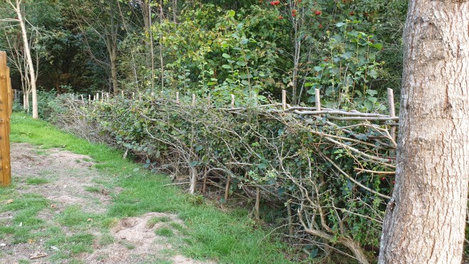
The woodland trail continues, via a couple of left-and-right shimmies, past a grove of Hornbeam trees

and debouches on to a road. A couple of hundred yards along that you dive off and emerge blinking into a large field (harvested, of course, this being Autumn); in the distance, you can see another mystery object.

As you get nearer, the object turns out to be an air traffic beacon – specifically, a VHF Omni-Range radio navigation aid.

To get to it, you have to cross the airstrip of the now-disused Wisley Airfield on a path between barriers. It’s a former wartime airfield; originally a grass airstrip, requisitioned in 1942 for WWII, the runway was converted to tarmac in 1952 and used to test aircraft built at Weybridge by Vickers. Flying ceased in 1973. The owners have recently been trying to get permission to build on it – so far unsuccessfully.

In case you’re interested, here’s what this area looks like from the point of view of a pilot using a chart to find a route:

OCK is the beacon, the circle is a compass rose to identify radial direction for navigation purposes. DME signifies Distance Measuring Equipment, so it also enables an aircraft using it to establish its range from the VOR. WISLEY has an X in its circle to show it’s paved but not in use (as you can see from the photo; in fact it gets used a lot – illicitly – by kids on motorbikes and the owners have stacked up piles of earth, tyres and other detritus periodically along it to try to discourage them). You can see Fairoaks on this chart (because you’ve been paying attention, you’ll know that that’s Chobham’s local airfield) and the edge of Heathrow’s Air Traffic Control zone, too.
Back to the mainstream of this post…..the path carries on past the beacon and then scurries along the side of fields all the way down the length of the Wisley airstrip, which is about a mile; you can see the airstrip on the Overview image above.

Across the fields, in the distance you can see the building work going on in Woking.

We took a short detour once we’d followed the track and re-emerged at the far end of the Wisley airfield. During this and previous Summers, we’ve had a wonderful crop of blackberries from bushes at this end of the airstrip, so we (meaning Jane) thought it would be interesting to see if there were any still worth picking. The answer was “not really”.

There were berries aplenty, but a one-two punch of heavy rain followed by an extended hot dry spell had ruined almost all of those that had ripened.
The trail leads beside the A3 before going under it to the north side; someone has major designs on it and if that’s the council, maybe improvement work will follow? Otherwise they’re just designs, and very colourful, too.

Once over the A3 and past the very posh Wisley Golf Club, a tiny detour enabled us to go and marvel at Ockham Mill, a wonderful building.

It’s one of a group of lovely buildings clustered around the mill pond, such as this
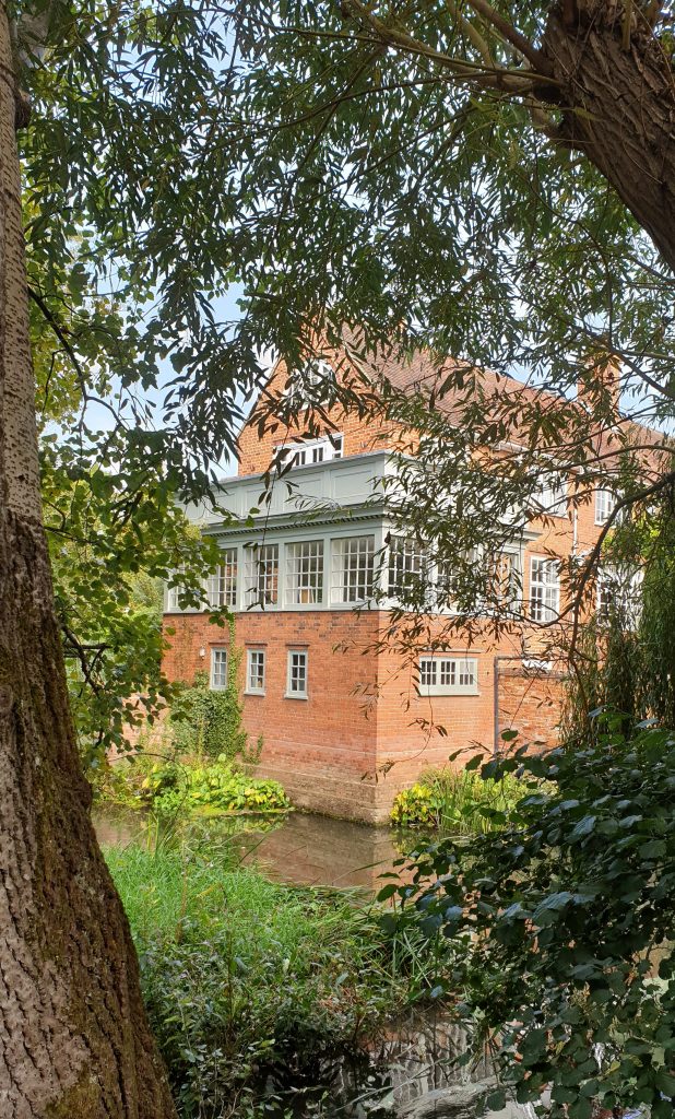
(I wish they’d cut back all that damn’ greenery so that passers-by can get decent photos of the place; can’t imagine why they don’t do this. Anyway, a gin bottle shot seemed a good idea.)

The path leads beside field’s where the farmer’s have clearly had problem’s in the past with dog’s (and punctuation).

The main crop appeared to be a variety of cabbages. I was very taken with a couple of ideas the farmers had used to keep pigeons off the crop.
In the background one can see the Glasshouses which are at the far end of the RHS Wisley Gardens.

The path actually goes alongside the gardens and one can catch glimpses through into them,

and a bottle shot seemed to be a good idea at this point.

At one place, our path intersected another going between different sections of the RHS gardens. Unsurprisingly, the RHS are not too keen on people using this crossroads just to wander into the Gardens without paying.

(I wonder how long it would have taken for their security people to find a senior citizen in a white hat and blue checked shirt in their 240 acres had I taken this opportunity to sidle in. But I’m far too honest to consider doing that. No, really. Anyway, Jane is an RHS Member…)
After the Gardens, the path goes through more woodland, which looked lovely in the late Summer afternoon light.

It soon becomes clear that, despite the sylvan beauty, one is near to several major roads, not least the M25: the traffic rushes by only a few yards away at one point and the traffic noise can be quite intense.


We then turned for home on the final stretch of today’s route, a broad made-up path that led past Pond Farm, where the Surrey Wildlife have a base and which takes its name from, well, a pond.

There’s a lot less water in it than there was earlier in the year, rather like Deep Pool. You’ll know all about Deep Pool because you read the earlier post, didn’t you? Didn’t you?
Eventually, we reached the steepest climb on the trail, which was the bridge over the A3 to get back to the car.

and we couldn’t resist a final bottle shot for the day.

Back at Ockham Bites, we treated ourselves to a bacon butty, which was OK, but the Award Winning Chef was clearly off duty today. The tea was nice, though, and the whole thing was most welcome because, despite today’s being a short walk, we were both feeling a little the worse for wear. Jane (who personfully carries the daypack we use to transport water and gin bottles, blackberry containers, power banks and other odds and ends) found her shoulders were aching and that there’s a spot of trouble with a tendon in one foot; my back was aching and I felt generally tired. So, in both cases, we felt a lot less fresh than we had at the end of, for example, the longer and more strenuous walk that we did yesterday. Perhaps Day 10 is where Walkers hit the wall? It will be interesting to see how we get on tomorrow, on a longer and more testing walk, which takes us back to the highest point in Surrey, although via a different route than our previous visit.
Today we covered 7.57 miles, a smidge more than the 7.18 of the Menorca equivalent, so we continue to be ahead of the game. We have covered over 90 miles so far and tomorrow will see our mileage hit three figures, so come back then and see how we got on.