Tag Archives: Spain

Gran Canaria Day 4 – Moments of Teror in the mountains

Monday 7 March 2022 – While the hotel we’re staying at is a very nice environment, I think we might need to Have A Word Or Two about some of the catering.  The restaurant on the day we arrived was a little patchy in its service and food prep, and the breakfast today was not properly organised; the lady in charge was too busy behind the scenes to notice that items on the buffet needed refreshing until someone pointed it out. We might give the restaurant another chance; after all, it was only its first or second day after reopening. But it’s a shame that such a lovely environment lacks a bit of care and attention in places.

Never mind – we managed to construct a reasonable breakfast and then headed out for the day’s travels.  The weather forecast promised that early cloud over the mountains would dissipate and so we headed out with the idea of making the central peak, Pico de las Nieves, the central part of the day, then head over to the west before wending our way back home round the north of the island.  Because of its geography, or possibly geology, or indeed maybe both, the best way to cover any significant distance on Gran Canaria is to drive round the major road which rings the island to the point nearest your intended destination and then head inland.

Let’s do a worked example.  Our first port of call today was a town called Teror. Our last, before we hightailed it back to the hotel was a village called Agaete.  To do that as efficiently as possible, Google maps suggests this:

basically 39 km in 39 minutes – 60kph.

On the other hand, you could go over the middle of the island, and this is the route we took.

According to the god of online maps, that route is 85 km, and would take 2 hours and 12 minutes, which equates to 39kph. And that, reader, would be going some; the Sunflower book of Gran Canaria walks and tours suggests a planning assumption of 15-20 kph on the mountain roads.  It would take fierce concentration and sphincters of steel to average 39kph.

Anyway, we took all day.  It was still buttock-clenchingly tense at times, but we escaped without any accidents and with several photos, to see some of which please read on.

We started in Teror, because it held the promise of some handsome buildings with an interesting variety of balconies.  And it delivered on these promises, erm, handsomely.

Here, for example, is the Calle Real de la Plaza.

As well as some lovely balconies, it has some interesting buildings, such as this one, which is covered in tiles.

The church is an imposing building

(sadly closed on Monday mornings for cleaning) and there are plenty of other interesting sights.

Among all this interestingness we noticed one thing which seemed a bit unusual; everyone was wearing masks all the time, even outdoors.  It didn’t seem compulsory. We started walking around maskless and no-one, not even a chap dressed in official-looking uniform, asked us to mask up or motioned that we should.  But the discomfort we felt at being the only unmasked individuals was greater than that of wearing a mask, so we completed our walking around wearing masks.

Jane had read about a particular thing, a water feature, she wanted us to see, so we trailed about looking for it, and….

it wasn’t running. We consoled ourselves with a coffee and then headed back to the car, past the very imposing town hall

before heading out.  It wasn’t long before we came to the first viewpoint of the day, the Mirador de la Vuelta de los Pájaros

after which we carried on further up into the hills.  The original plan had been to head to the highest point on the island, but that depended on the clouds clearing, which it began to look like a distant prospect.

The Canary Pines in the photos above had been the site of pretty significant fires in 2017 and 2019, and you can see the demarcation between the areas affected and not. We read that the pines are pretty resistant and should survive.

A little further on, another “astronomica” viewpoint on the way persuaded us that perhaps heading any higher would be optimistic

and so we rather headed down; soon after the above scene, we saw this

which is pretty much the view we would have had from the formal viewpoint, but you can see where the cloud starts.

Having decided to avoid going higher, we headed off across the island, with the distant destination of La Aldea in mind.  En route we passed some attractive scenes.

Above is Candelaria, which is very attractive but utterly remote. We wondered how the people who lived there managed for schools, shops, doctors and such.

I took this picture at a mirador called la Atalaya.  Overall, the views were not that  fabulous, but I liked what looked like a fringe of single trees on the horizon, like injuns about to spring an ambush (can one say that sort of thing these days?).

Very soon, the very twisty and often nerve-rackingly narrow road took us into some Big Scenery – Very Big Scenery.

We passed a viewpoint called the Mirador del Molino, mainly because it had the remains of a mill there.

More to the point, it had rather a spectacular view over a lake called Presa del Parralillo.

If you look at the left side of the photo, you can see the road running downhill towards the dam at the end of the lake.  When you get down there, you can look back and just about make out the mill.

The road led past the dam

at which point, some 25km into this precipitous, narrow and winding road, The Powers That Be put up the most spectacularly uncounterintuitive sign.

Mind you, they might have been referring to the cyclists, who were alternately toiling up and whizzing down the road in completely lunatic fashion.

We stopped for a late lunch in La Aldea and I tried my hand at yet another arty photo of the scene just by the café.

Then we carried on towards the end of the mountainous part of today’s excursion.  Not, it has to be said, without some more buttock-clenching moments.

This lorry was one of what seemed like an endless stream of heavy vehicles headed in the opposite direction.  We think it has to do with creating a tunnel to bypass the twisty bits.  The tunnel is complete in places, and I must say that it’s a lot more relaxing to drive in than the roads it is due to replace.

La Aldea, where we had lunch, is the centre of the fruit and vegetable growing part of the island, and as we took the road out of it, we got a sight which shows the extent of the area given over to growing stuff.

The whole basin of the valley is covered in vast areas of netting to protect the crops – an extraordinary sight.

We rather thankfully headed towards the tunnel, but, before we went into it, diverted to a noted viewpoint, the Mirador del Balcón. Actually the view from it was so disappointing that I didn’t bother to take any photos, but it seems that its main purpose is for people to behave like tourists on it – who gives a crap about the actual view when you can arse about in front of it, eh?

Before we hit the final stretch of the main road home, there were a couple of interesting vignettes:

Above, the village of Gáldar, clustered round the base of a volcano; and, below, a couple of shots of parts of the town of Algaete

including this slightly strange complex of buildings.

And that completed the day’s touring – some lovely views, big scenery and terrifying roads.

We’ve covered quite a lot of ground over the last three days, but there are still lots of possibilities for new and exciting things to do tomorrow – Gran Canaria certainly offers a varied mix of scenery, history and culture to be explored. We haven’t decided what we’ll aim for tomorrow, so you’ll just have to come back and find out for yourselves what we got up to, won’t you?


Gran Canaria day 3 – It all depends on your viewpoint

Sunday March 6 2022 – The day dawned with a great deal more sun in the sky and a great deal less wind in the air, which meant that the plan that Jane had formulated for the day looked a good’un. The idea was to hie ourselves swiftly down to the south of the island, taking up where we left off yesterday, and head up towards the central peak, taking in viewpoints and other items of interest on the way. As usual, we had a lot to get through.  As usual, we didn’t achieve it all. As usual, we had a lot of fun trying.

The journey down to the south of the island takes about 30 minutes, during which I managed to get almost entirely to grips with the cruise control on the Peugeot without, I’m glad to say, causing any accidents, at least none that I noticed. Having got back to Maspalomas, we headed northish to something that Jane had spotted on Google Maps, which was an aqueduct built out from the rocks, which looked like it might be quite interesting.  So we drove up to the point where the road became a track and then walked up the track.  It was so beautifully not windy that I could actually wear a hat as protection from the sun, which was obligingly shining fit to split any paving stones it happened upon. After a short walk, we saw the aqueduct, which  was indeed built out from the rock on to arches.

That was the thing we’d come to see, but whilst I was scrambling across the terrain to capture the photo from this particular angle, only getting lightly injured in the process, Jane had noticed that a little further up the track the aqueduct went across some further arches.  So we walked up and examined them, initially from a distance

and then decided that it might be possible to scramble up and take a look at the water course itself (Jane had seen a photo of water flowing along the aqueduct).  So, scramble we did, and we managed to get up to the arches, at which point we saw

that the water now flowed along a pipe rather than in an open channel.  While it makes a great deal of sense in terms of saving on evaporation and being more efficient, etc etc, it was a little disappointing to find.  However, getting up there enabled us to get a better view of the very enormous rock processing facility across the way,

and heading back down gave us some more photos of and through the arches.

On the way back down to the car, we noticed that there were some caves by the track.

We’re not sure of the provenance of them, but they look like they might have once housed people.

Our next stop was at a viewpoint a bit further up the into the hills, with the grand title of Mirador Astronómico de la Degollada de las Yeguas. It being a Sunday, and the mirador being up a twisty mountain road, it was very popular among the local biker population.

The use of “astronomic” in naming the viewpoint comes from its popularity for watching the stars – not like The Ivy or the Wolseley, I mean the night sky.  It apparently gets dark at night without getting cold, which makes it a good place to gaze at the heavens.

But even during the day, you get a pretty staggering view. It’s a huge panorama.

Our next stop was a necropolis.  Sorry about the focus on death here, but it can be interesting.  Just up the valley, near the village of Fataga, is the necropolis of Arteara.  This is not a vast and impressive spread like the one we saw yesterday or in Menorca, but we thought it worth investigating anyway.

There were signposts to the site, but it turned out that the necropolis itself is quite subtle and not at all easy to spot until you know what you’re looking for. There is a track of sorts, which leads you to a viewpoint

from which, an information board tells you, you can see many many tumuli (burial chambers) among the rocks.

No, we couldn’t spot them, either. However, once you know what you’re looking for, you  can begin to distinguish them.

There’s one pretty near the centre of the photo above – look for a hole in a pile of rocks.  Here’s what it looks like close to.

Bodies were laid out on cists (platform slabs) and then covered with more rocks.  The local reddish stone is easy to break up to be able to do this, we are told.  After a bit, you can see tumuli all over the place.

and you can begin to understand how it is that there are over 200 tumuli in total across the site.  Jane had seen some pictures of a neolithic cave network, but we couldn’t find that.  What we did find instead were some traditional beehives, constructed from the trunks of palm trees

and some very fine views over the area.

The palm trees are further evidence of the neolithic community that once lived here.

The nearby village of Fataga had a couple of restaurants and so we thought we’d try our luck at getting some lunch.  Remarkably, we were able (a) to park the car and (b) to get a table in a very busy restaurant called  El Albaricoque. They managed to fit us in and served us a decent lunch with, mirabile dictu, plenty of vegetables, a constituent that has largely been missing from most of the meals we’ve had here; and we’re of an age where getting one’s veg is almost as important as getting one’s Earl Grey tea.

The restaurant was next door to an art gallery which looked like it would have been fun to visit, had it not been Sunday and therefore closed.

Time was beginning to motor on by this stage and so we decided we’d better do the same, therefore ditching a couple of the optional sites to visit in favour of basically hightailing it back to the hotel across the middle of the island.  Since the middle of the island is a fucking great very substantial mountain, we had quite an intricate journey along roads that Jane is fond of calling “intestinal” – narrow, twisty and occasionally making one shit oneself. However, the route went through an attractive town called Santa Lucia, and I couldn’t resist stopping to take a few quick photos.

And as we wound (a very apposite description of the roads) our way towards home in the setting sun the light gave us some absolutely marvellous views along the way.

We arrived back at the hotel well after sunset, and, as ever not having quite hit all the targets we had originally planned.  But it’s been a good day and I managed those twisty roads without damaging the car in any obvious fashion, which is good.

Jane’s plan for the morrow involves going to the north of the island.  Hitherto, the weather in the north has not been brilliant, but the forecast for tomorrow is good, so we shall sleep well and optimistically tonight with the prospect of another good day tomorrow.  So please come back to these pages soon and take a look at how we get on.

Gran Canaria day 2 – Blown to buggery everywhere

Saturday March 5 2022 – Jane had, in her usual organised fashion, sorted out an approximate plan for the day, which involved gradually working clockwise round the island.  Our hotel is at about 2 o’clock, just where the hour hand ends, and the plan was to visit places at about 3 o’clock and every half hour thereafter until 6 o’clock. This was an ambitious plan. Very ambitious, as it turned out. Actually, like many of our Lanzarote plans, unachievable. But we had fun trying.

First port of call, then was El Bufadero, a blow hole on the east coast at La Garita. The sea comes in hard there and the blow hole is a rock formation which fills and empties with sea water as the waves pound it. When we got there, we realised that we wouldn’t safely be able to see the blow hole close to because the wind was so strong and gusty (later checking in with the local weather map, it transpired that gusts were up to 80 km/hour). So we stood well back and I tried for some video, which you can see below.  I used a stabilising gimbal, but the wind was so strong that it played havoc with it.  One thing that engaged our interest was what looked like little puffs of steam coming up from a particular hole in the rocks – looking like a mini geysir.  Anyway, the footage is not brilliant, but you can view it here if you like.

Moving a little towards the centre of the clock face took us to the outskirts of Telde, where there is a handsome basilica, the Basílica de San Juan Bautista.  En route, we noticed that there is a distinct tendency to have fun with the roundabouts.

The basilica is quite handsome, if a little sombre in appearance.

and it’s beside a square where parents were bringing small children and clearly Something Was Going To Happen.

We never found out what was going to happen, sadly. The basilica is quite ornate inside, as is  typical of Catholic churches.

Jane found on Wikipedia the nugget that the statue of Christ on the main altar, made from corn dough by the Purépecha Mexican Indians, was brought here before 1550. So, erm, there.

The square (and the town generally, actually) has some nice buildings, many of them featuring elaborate balconies.

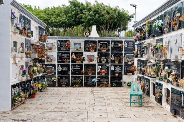
We had a coffee in a mad cafe (whose main and flourishing business seemed to be selling a variety of spanish hams, either as sandwiches or simply as ham by weight) nearby and decided we needed to get on, so headed back to the car via the cemetery (we’re odd that way)

a park laid out in tribute to a local man by his artist wife;

and other remarkable statuary.

We found a lot of artwork just generally lying around in our travels today – see later.

Inching round the clock face towards about half past three (via another roundabout, this one a mobile driven by the wind)

took us to Cuatro Puertas, a neolithic site, which put us in mind of the necropolis at Cala Morell on Menorca, although having none of the grandeur of that remarkable site. Cuatro Puertas means four doors, and this comes from the second thing you see as you stumble up the hillside in the howling bloody gale that was still lashing us every time we got out of the car.  The first thing is actually a house, which is magnificently isolated

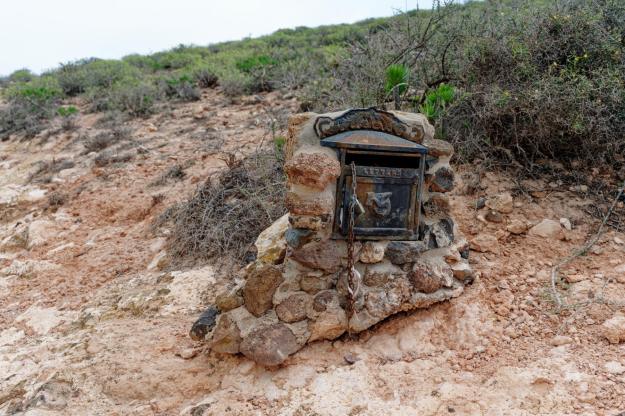
but still has its own letter box (a hundred metres or so down the track at the point it stopped being surfaced).

There doesn’t appear to be anyone living there at the moment, and I suspect it takes a particular kind of individual to want to live in such isolation.

Anyway, trying not to be blown off our feet by the wind, we made our way to the first of the site’s sights.

As it says on the tin, four doors. Although the rest of the site is not large, it took us a while to explore it.  It was quite impressive (I have lots of photos but will try not to bore you with too many of them); and the wind was a real factor, because the site is basically at the top of a cliff and it felt at times as if there was a real danger of being blown over it. Stumbling up and down uneven rocky surfaces was bad enough – add 50mph gusts and at times it was quite terrifying.

There are some more caves along a path

and the arch on the left hand side would have been the perfect frame for a brilliant photo had there not been a bunch of people having a picnic in THE MIDDLE OF MY SHOT! However, they had every right to be there (I type that with gritted fingers) and we actually found some other great excavated spaces and some markings on one of the walls

which we’re defiantly taking to be neolithic painting rather than modern graffiti.

The site gives some great views over the local countryside, too.

and a local inhabitant was trying to tell us something

but we don’t understand pigeon Spanish, so we ignored him.

Around about 4 o’clock on the clock face of today’s expedition, you’ll find a ravine (barranco in the local tongue) called Guayadeque, which has, at various points along it, restaurants, some of which are actually built into the stone of the ravine.  So it seemed a good idea to aim for lunch in one of these, our favourite prospect being Restaurante Vega at the top of the ravine.  So we started off, and paused en route to take a couple of photos.

But as we got towards the top, it gradually became clear that every other bugger on the island had exactly the same idea, only about an hour earlier than us.  The road around each of the  restaurants was crowded, there was nowhere to park and it would seem that all the places were full.  So, reluctantly, we decided to turn back (actually, that bit was forced upon us by the dead end at the head of the ravine) and find lunch elsewhere.

Elsewhere turned out to be Agüimes, which is around about half past four on the clock face. Because every other bugger was up the bloody ravine, there was actually a parking space available in the town, and so we headed down towards its centre and treated ourselves to a lunch of local grilled black pig, which was actually pretty good.  The restaurant was just by the parish church of San Sebastian.  For a parish church, it’s quite substantial

and quite impressive inside.

Its square features statuary at each corner

and the town wouldn’t be complete without a statue of the eponymous San Sebastian, complete with his arrows.

I also took this photo of a building in the town, which I find satisfying for no real reason.

The day was getting on by this stage, so we thought we’d better cut out a couple of intermediate items on the plan and head straight for 6 o’clock on our clock face – the dunes of Maspalomas.

These are, erm, sand dunes at a place called, erm, Maspalomas.  The south of the island is a hotspot for the beach-loving kind of tourist; generally the weather in the south of the island seems to be better than in the north, probably because the prevailing wind is from the north and expends much of its venom on the northern half, with the central mountain taking the sting out of it for the southern half. (A similar pattern exists on La Palma, another of the Canary Islands, which has a central mountainous spine – the leeward side of the spine generally has much gentler weather.)

The Maspalomas dunes area is very popular.  Again, by another miracle, we were able to park and we made our way down towards the sandy bit, past lots of beach-holiday-type apartment buildings. The initial sight of the dunes is quite impressive

and it’s a pleasant walk to the mirador which is the centre of the attraction.  There, one finds lots of people behaving like tourists

and it’s quite popular for people to walk among the dunes.

It was much less windy here, but there was clearly enough wind to shape the sand into characteristic ripples

and I can imagine it might be possible to have quite a zen moment out there.

But you won’t catch me doing it, that’s for sure.

Anyway, we were at 6 o’clock on the clock face and the real time was also 6pm, so it was time to wind our way back (see what I did there?) to the hotel for a Nice Cup Of Tea.

So, we hit quite a few of our planned targets today, but there are still some places to visit in the south and so we’ll focus our energies there tomorrow. Apart from anything else, the weather in the south of the island is forecast to be much nicer than in the north, so we’ll hope for sun later when we go anticlockwise on our visits.  So, check in again tomorrow and see how we got on round the island’s clock face.