Wednesday 8 May 2024 – It was clear, immediately we awoke, that I was not going to be able to cope with a 17km walk, even if it were on the straight and level, which it very emphatically wouldn’t be.
I was therefore going to take a cab. As Clint Eastwood said, “A man’s got to know his limitations.” Given that the forecast for the day was benign – sunny, mid-20s Celsius, It seemed selfish to rob Jane of the chance to hike what we had been told was a beautiful walk by suggesting she come with me. I was worried that I wouldn’t have enough efectivo (cash) and so we buggered about for a bit with how to get to an ATM first, but the hotel reassured us that the fare would be just €20, which was fine.
The hotel staff, I have to say, were magnificent in their support for us, and in particular me. They provided isotonic drinks, arranged the taxi, allowed me to have a late check-out so I could stay in my room and thus within sprinting distance of a loo, and took our bags down to the taxi (I’m not sure why the normal baggage pick-up didn’t work, but that’s not important right now). So I was entirely sorted and comfortable with the plan for the day.
The only ripples in the otherwise smooth current of my transfer to Lires occurred at the “getting into the taxi” stage. The taxi had turned up and been loaded and the hotel manager had come with me down the steps, but the taxi driver was Over There, apparently having a chat with someone. When he turned round, it transpired that he’d been importuned by the leader of a group of three people who couldn’t be arsed to order their own taxi, as they wanted to get back to Finisterre town. So it was that three somewhat overweight people joined me in the cab. I don’t know where they were from (somewhere like the Philippines, at a guess), but their leader was obviously accustomed to taking things over and running them his own way. He even asked the driver what would be the fare to Santiago, which alarmed me. But they eventually got out Finisterre and left the driver to take me to Lires.
That’s my contribution to the day. Let me hand you over to Jane, who has a much more interesting narrative.
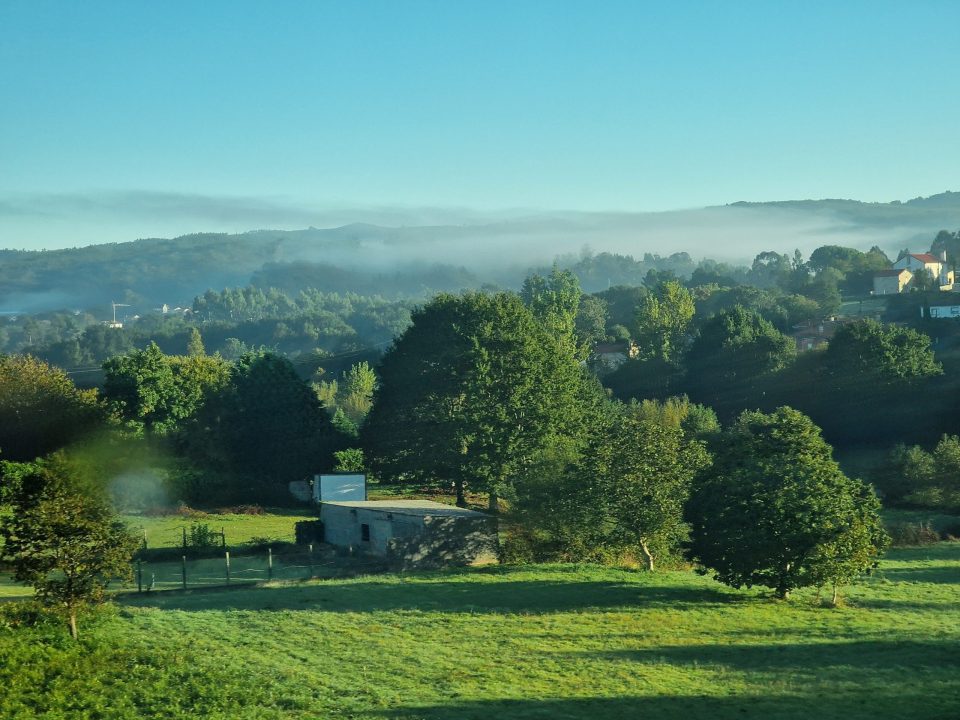
Secure in the knowledge that Steve was all set, I started out with a spring in my step into a glorious morning. Blue skies, a cool breeze and beautiful valedictory views of O Semaforo, the lighthouse, and Cape Finisterre.
There were not many peregrinos walking in either direction so I was able to take my time as I retraced our steps of yesterday back down the Cape into the town of Finisterre; the views and especially the colour of the water in places were wonderful.
Curious to see nasturtium flowers running wild, nowhere near any gardens!
The route led up through the town past some colourful artwork then out into open country.
From our previous experiences on the Camino we are used to the kilometre-posts showing distances to key points (usually Santiago for the main paths, or Finisterre or Muxia for those heading to the coast). On this road, between the twin “end-points” of the Camino, Finisterre and Muxia, they do things differently: as peregrinos might be travelling between the two points in either direction, they simply make sure you continue heading the right way!
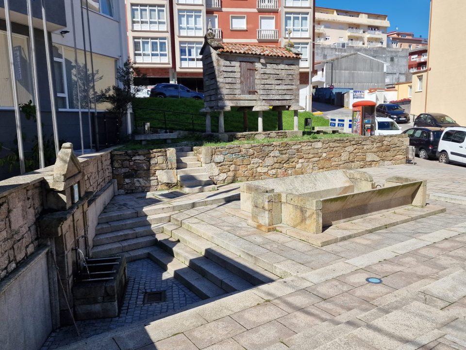
The going at this point was quiet country roads through farmland and tiny hamlets. Lots of horreos – some even being used for their original purpose!
I was quite pleased when, around halfway through my walk, the nature of the way changed from open country – it was getting hot! – to shady woodland paths
although I was mystified by the appearance of small pilgrim rock “statues” all of the same general design with a stick for a staff. They were perched on the kilometre-posts, sitting on the verges and the walls, for quite a distance. Then the mystery was solved when I passed a ramshackle building proclaiming itself to be “The House of Pilgrims” and displaying a bewildering selection of the little stone pilgrims!
Soon the way opened up views of the coast and the sea
and continued through woodland (mostly pine, a relief after the relentless eucalyptus)
to the outskirts of the village of A Canosa. It was at this point that my personal GPS map, courtesy of our organisers Walk The Camino, let me down. The map has a black line (sometimes more than one if there is a choice of route) which exactly indicates the route we should take. At a T-junction, the black line went left, the signposts most emphatically went right. Since we had always found the black line to be a reliable and sometimes preferable route to the direction markers, I decided to follow it.
This proved to be a mistake as the path went from bad, to worse
to impenetrable, so I had to retrace my steps and shamefacedly follow the arrows… which led through the village and onto a much better path which eventually rejoined my black line. Ah well, serves me right for trying to be clever!
Eventually I reached the outskirts of my destination, Lires
and our hotel
where I found Steve with his taxi story to tell!
[Steve again…]
Once we were reunited, we spent a little time resting in the room, me because I was still feeling somewhat ropy and Jane because she’d just toiled over 17km in hot sunshine, As ever, this led us to fall foul of the Spanish eating calendar and the local restaurant had stopped serving until 7pm. Our hotel does have its own restaurant, but its closed on Wednesdays. However, the friendly and helpful chap at front desk sorted out a couple of snacky items which, as it turned out, were all we needed for the rest of the day.
And so to the morrow: for me to walk it would be too ambitious, based on our experiences so far – weather maybe a degree cooler, but with a reasonable ascent and steep descent to be undertaken – for me to contemplate it. So the profound hope is that the hotel can help us with a taxi, and we’ll travel independently and meet up in Muxia. Why not come back soon and find out how it went?
Monday 2 October 2023 – As satisfied as we might have been with our 800 kilometres of walking the Camino Francés, one could say that we hadn’t actually completed the staff work. Yes, the Camino primarily leads to the Cathedral of Santiago de Compostela, because the remains of Saint James the Apostle are believed to be buried there, but some pilgrims choose to continue their journey to Finisterre and Muxía, on the west coast of Spain, for a few reasons, historical, symbolic or traditional among them. We had, in our way, chosen to do this, but it would be by bus, not on foot (walking to Finisterre would have added three days minimum and some 80km to our pilgrimage).
Thus it was that we found ourselves standing outside an underground car park at 0845 waiting for a coach to turn up and whisk us off to Finisterre and Muxia so that we could at least see what lay at these two significant and symbolic end points of the Camino.
The itinerary turned out to be a lot more varied than I’d expected, and involved no fewer than seven stops. It was a pretty standard tourist setup – coach with guide, stopping at places so everyone could scramble off the bus and wander around for a few minutes taking photos before getting back on and being whisked off to the next place.
The weather was quite cool as we started, and as a result we could see the mists in the valleys as we went along.
The first place we stopped at is a staging point on the Camino as it wends its way coastwards. When we arrived, because Pontemaceira was (being centred around a bridge over a river) in a valley,
It Would Have Been Better If It Were Clearer.
Despite the poor visibility, one could see it was a charming place; I can imagine it to be eye-achingly photogenic in the right conditions. The bridge from which the village takes its name is a 13th-century bridge built upon the foundations of an earlier Roman bridge, and the place (which, Wikipedia tells me, has 73 inhabitants) is a monumental village. That means it’s a village which is in itself a monument rather than one which is huge. It has a couple of dwellings, a chapel, two old water mill buildings and a more modern manor house. One can look into the mill buildings
and see the river Tambre rushing past underneath to give some idea of what would have powered the mills when they were operational. I really wish that (a) the weather had been clearer and, if so, (b) we could have had longer to take photos. The whole thing was a bit rushed, but that’s not unusual for these kind of tourist outings.
So it was back on the bus and off to the next destination, which was a fishing village with, it would appear, a speciality of farming mussels. There were some large platforms out to sea, reportedly some 25 metres square.
As you can see, the sun had burned off the mists, and was shining strongly, making Muros look very pretty.
Again, we didn’t have much time to wander around, but then again the place didn’t have much to offer. I’m not quite sure why we stopped, to be honest; it was perfectly pretty, but didn’t really add anything to what I perceived to be the mission of the day trip, which was more to do with the Camino.
Neither did the next stop, which was, again, pleasant enough, but slightly puzzling. At Ézaro there’s a waterfall which is unusual in that it debouches directly into the sea. Also unusual is the amount of tourist infrastructure in place for something which is nice enough but doesn’t have the gravitas to merit what one finds there. There’s a tourist centre, with a cluster of outlets – souvenirs, clothing, ice cream, coffee, all under a large shelter with plenty of seating. To get to the falls, there’s a very well-engineered walkway, which leads past a thundering great hydro-electric facility; this made me wonder whether the price of being allowed to set up the plant was an obligation to provide the somewhat over-engineered tourist facilities. The falls themselves,
at least when we saw them, were, well, just these waterfalls, you know? It may be that the hydro plant was extracting lots of water and the tide was low; perhaps on another day they would even impress an Icelander. Anyway, we scarcely had time to have beer and crisps and visit the falls before we had to hurry back to the bus and on to the next destination, which was Finisterre.
I was keen to see Finisterre, principally because of its status as an end point of Camino pilgrimages. It was named by the Romans, as they thought that it was, literally, the end of the world – Finis Terra. Also, the name was familiar to me as one of the names in the UK Shipping Forecast, along with Rockall, Dogger Bank, German Bight and the rest of them. I started to look for a chart of where the Finisterre area was and made a discovery that quite startled me: it no longer exists! It used to be the area, as one might expect, to the north-west of Spain, adjoining Biscay. However, its name conflicted with a different Spanish meteorological area definition, and Spain won the international wrangling over the name, So the Finisterre name was dropped and the area has been christened FitzRoy, named after the grandpa of all shipping forecast areas, Met Office founder and HMS Beagle captain, Admiral Robert FitzRoy.
This, by the way, was back in 2002. And no-one told me.
Finisterre was not the desolate, windswept outpost I expected. There’s a rocky outpost, yes, which is a lighthouse at the top of a cliff
but it’s not desolate; it even has its own hotel.
OK, there may be only six rooms in the hotel, but as soon as I learned that it was possible to stay there, a plan started hatching in my mind, matching the one which had been forming in Jane’s for several days now: we could do one of the other Camino routes, with the Portuguese one being the favourite, and finish with stay at the hotel. More on that plan later…
The Finisterre lighthouse is a popular tourist destination, and so there were a lot of people there as well as the contents of our coach. There is a “zero kilometre” Camino marker there
which is inevitably a selfie magnet, though I don’t believe that any of the people queuing up to have their face in a photo of the marker had actually walked there. There are a few other things at the site: a small memorial cross;
and a rather nice symbolic boot.
The lighthouse was built in 1853, in part to address the reputation of the coastline as the “coast of death”, because of the appalling loss of life due to shipwrecks in the area. Its light is reportedly visible at a distance of 30 nautical miles. Except in fog, of course. For that eventuality it was equipped with a siren that sounds like mooing, so it has the nickname “the cow of Finisterre”. I have a picture of the cow’s horns.
The lighthouse is, of course, right at the tip of the land, because its usefulness would be limited were it elsewhere. I thought that there was nothing else there, or at best a few shacks. I was therefore surprised at the size of Finisterre town, at which the coach stopped after we’d visited the lighthouse.
It even has its own castle,
although it’s rather small and is now in use as a fishing museum.
We wandered round the back streets of the town
which has one of those “Spanish open” – i.e. closed – churches, and also a rather engaging chapel, Capela de Nuestra Señora del Buen Suceso,
and also a lavadoiro,
albeit one which doesn’t look as if it gets a whole lot of use.
There are numerous eateries along the seafront by the harbour, and we managed to choose the one which gave us the single most horrible cup of coffee in our entire Spanish travels before going back to the bus and on to the next destination.
Muxia was also not what I expected. Having seen the film “The Way”, I expected a dark, desolate, rocky, windswept outpost, lashed by Atlantic seas, with a dark stone church as the sole construction there.
It wasn’t quite like that.
For a start, there’s a very impressive monument, which was erected in recognition of the events of 13 November 2002, when the oil tanker ‘Prestige’ ran aground at Muxia, spilling some 75 million litres of oil into the Atlantic and along the coast from Portugal to France, with Muxia being the worst hit. A massive cleanup followed, which means that the site is now pristine.
The monument takes the form of a broken rock – symbolic of the break in the ship, the wound to the sea and also of how the disaster divided the community through the economic hardship engendered by the damage to the area. The monument is called “A Ferida” (“The Wound”) and was sculpted by local artist Alberto Bañuelos.
In front of the monument is the other “zero-kilometre” marker for the Camino. “How,” I hear you cry, “can there be two places which are at zero kilometres?” There are two Camino routes which start at Santiago de Compostela; one leads to Finisterre (called Fisterra in Galego, the language of Galicia), and the other leads to Muxia.
Each of them is around 90km in length, but to receive a Compostela for these Camino journeys, one has to complete 100km. This means visiting both by foot, in either order, adding some 30km to the total.
Can you imagine how the plan hatching in my head is developing?
Anyway, Muxia. This is what it looked like on the day we were there.
The church is the Santuario da Virxe da Barca, the Sanctuary of the Virgin of the Boats. It was originally a pre-Christian Celtic shrine and sacred spot. This part of Spain was resistant to conversion to Christianity, and was only converted in the 12th century. The Christians built a hermitage on this location at first, and later the present church in the 17th century. Throughout the centuries, it has been a magical-religious object of worship and of veneration for thousands of Camino pilgrims travelling from Santiago to Muxía. In legend, it’s the place where the Virgin arrived in a stone boat to inspire courage in the Apostle James. The church was closed, but Jane managed to get a photo of the interior through a window
and if you look closely, you can see small models of boats hung inside.
We are told that when a fisherman gets a new boat, they offer a model of it to the church to ask for protection – presumably similar to those we saw hanging from the ceiling of Notre-Dame-de-Bon-Secours Chapel (The Sailors’ Church) in Montreal, Québec when we visited last year.
I would have liked to spend more time at Muxia, which is a very charismatic location, but, once again, it was time to head back to the coach for our homeward journey. This was interrrupted by one final Tourist Attraction, probably the most unusual of the entire day. This was
the longest and oldest hórreo in the world. Well, the oldest one with an actual documented history anyway. – 27 metres in length with 22 pairs of legs, and looking rather like a millipede.
The size of your hórreo depended on many things, such as the size of your harvest. Each harvest used to be subject to a tithe – a tenth, given to the church. A large hórreo such as this might well have belonged to the church and been used to store the tithes that had been taken. One nugget we learned on the trip was that in Galicia the hórreos are under a preservation order – they may not be destroyed. That accounts for why there are still so many around the province, as well as why so many of them are so obviously disused and decrepit..
That was it for our day trip. It was great to see Finisterre and Muxia, and I expect we will visit them again as end points for another Camino, possibly even from Lisbon. The other destinations? Well, they had some charm, I suppose, particularly Pontemaceira, which I think would have been stunning on a decent day. But we learned a few things and saw some more sights and, moreover, got back to Santiago in time to do a final bit of shopping to (eventually!) get hold of a bottle of a particular Galician gin,
to which we’d been introduced in Casa Marcelo, and which we wanted to contribute to our hosts on the final segment of our stay in Spain. We are now headed for the wilds of the Galician countryside to relax and eat and drink a great deal more than is in line with current government guidelines. Thank you for joining Jane and me on our journey from the south of France to the west of Spain. These pages are about to go quiet for a few months until our next expedition, which is planned for February next year. I hope that you’d like to subscribe to the blog (provide a comment, provide an e-mail address and ask for future updates) so that you don’t miss out on what we hope will be a spectacular holiday travel. Until then, hasta luego!