
Wednesday 16 August 2023 – My 71st birthday, by God, and what’s my present? Probably the toughest day of the whole Camino Francès!
This was a long day, and this is a long post. Here’s the tl;dr version if you’d prefer to go out instead.
For the rest of you, here’s how the day went.
Because of the likelihood of having to do lots of tough uphill work in blistering heat, we wanted to leave the hotel as early as we could, an ambition somewhat thwarted when we couldn’t find the hotel room key to return it as we left. Much swearing and checking through bags ensued before we decided to confess our sin to the manager and hope we might be forgiven. Turns out that we’d left the key in the outside of the door last night, so he carefully removed it and took it downstairs.
Didn’t tell us, though, did he?
Anyway, the hotel breakfast was pretty good

but you might be able to make out that the distant hills were shrouded in mist. We left our bags to be transferred to our destination (in reception every morning by 8am is the rule) and started out. The town’s streets were eerily quiet after yesterday’s Assumption Day crowds

and we made our way to the Notre Dame gate for the obligatory “This is us starting off” selfie – one of the very few occasions when I will countenance such self-indulgence.

Off we went along the roads


and it became clear that the mist wasn’t about to disappear. You’ll have read yesterday’s blog so you’ll know that I have been basically bricking it about this day’s walk and particularly the tough climb to the first and, as it turned out, only refreshment stop at Orisson as part of a long and largely uphill journey to our destination, Roncesvalles (Ronceveaux in French).

The serious uphill started pretty soon

but the blistering hot sunshine I’d feared never materialised, as it was very misty.


There were a few peregrinos out

many of whom overtook us as we started, making me feel like I do out on a bike ride when I get overtaken, which is not an uncommon occurence. However – hah! – when the uphill going got tough, they all seemed to find lots of excuses to stop and chat and adjust things, so we overtook them in turn. Not that it’s a race. No. Not at all.
The first few kilometres were a steady uphill pull, but then the road steepened and it became really brutally steep, particularly as we left the road for a track.


It reminded me of the gradient I had to deal with on one occasion during a walking holiday in Slovenia in 2016. Then, I had to cope with 40 minutes up such a relentless gradient, and it nearly did for me. So I was delighted to find that, seven years older, but lighter and much fitter, I could cope with the gradient for well over an hour without my heartbeat going particularly high and, more to the point, without finding it at all daunting. This is a major change for me; it used to be normal for me to really hate having to walk uphill.
This is going to make all the difference to this Camino for me.
Mind you, we were lucky with the weather. The mist made photography a bit challenging, since only rarely could one see anything through the mist;


but on the other hand it was cool, which made walking uphill much easier.
The day was rather like Walker Family holidays over the years, only more so. The traditional Walker cry is “It would have been better if it were clearer”. In this case, it might have been better if we could see something.
Anyhoo…
After about two and a half hours we arrived at Orisson


which gave us a rest as we had coffee and sandwiches. Ordinarily, the view from the panoramic terrace is a thing of beauty. Today?

Not so much.
After our refreshment break we walked on and the mists cleared for a bit,

then didn’t,

then sort of did, a bit.

We passed a strange-looking cairn

and then the road split. There was a choice – go downhill or go uphill. Guess which was the correct option? Correct – uphill we went

to the Orisson statue of the Virgin Mary,

where once again the ability to see the view was a transient thing.


All around us in the mist was the tinkling of bells, indicating that there was a lot of livestock somewhere around.


We reached Thibault’s Cross,

where our info asserted that a food truck operated “in the season”. Today, not. Just as well we weren’t depending on it, then.
After the cross, we once again left the road for tracks


 This is not a stile I would care to use, personally
and arrived at the Spanish border.

Just beside it is Roland’s Fountain

(Roland was the Frankish military leader at the Battle of Roncevaux Pass in AD 778, by the way).
We carried on into Spain

past an emergency refuge hut


where one could spend the night in extremis – water is provided, and there’s a fireplace and a place to put your sleeping bag.
On we climbed, and, as we did, the mists started to fall away. As we got to the highest point, it was absolutely clear sunshine.

I decided to try to get some aerial photography – video of reaching the top and climbing to pan round to the fabulous view was my plan; I’d even practised it at home. So I got out the drone that I’d carefully and specifically brought along for this very occasion and whizzed it up.
There was a frisson at one point when a lorry wanted to drive down the path I was standing on, but we carried on – and the clouds came in again so that view was no longer visible.
Rats!
However, nothing can be done about the weather, so we started down again.
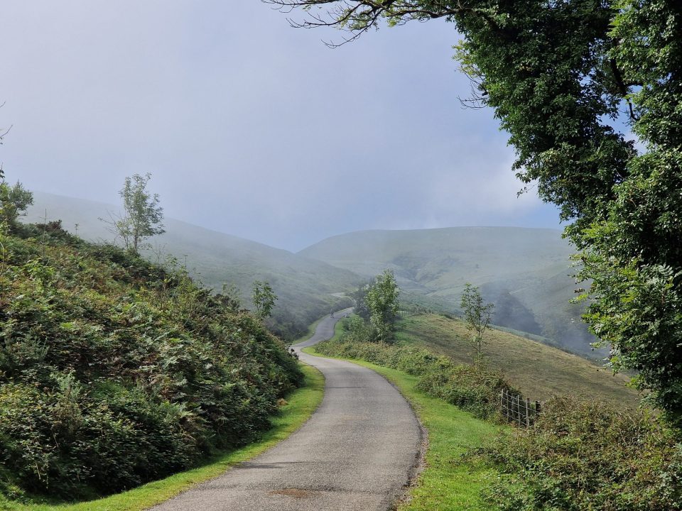
We were above our destination, Roncesvalles, at this point and had a choice of route to get down: the road – less steep but more boring

or the track you see going ahead in this picture – steeper (much steeper, as it turned out) but more wooded and therefore protected from the sun. After some dithering, we took the track, which wound relentlessly and quite steeply downhill

for what seemed like ages, but can’t have been because its total distance was less than 4km. Eventually it levelled out a bit into lovely beech woodland

which is quite similar to what we’ve seen above the Tillingbourne River on our Surrey walks.
Eventually, we walked sufficiently far down that the mists closed in again.

It seemed to take forever to get down, and we were both feeling that we’d really just like to be there now, thank you very much. Eventually, we reached civilisation

and walked into a very misty Roncesvalles


 Memorial to the Battle of Ronesvalles Pass, apparently

and (eventually) found our hotel, arriving at about 5.30pm, nine and a half hours after we’d left SJPdP.

It became immediately apparent that we’d moved from the ridiculous to the sublime. Inside was very swish,


but actually we didn’t care that much because we were very tired and what we really wanted was a drink. We had a huge room with three beds and a separate lounge area and, importantly, facilities for making tea. Its drawback was that it was on the second floor, and I discovered, when I tried to be a hero and bring both suitcases up all those stairs, that my knees were buggered. It’s happened before after a long walk, but I’d thought that the hundreds of miles we’d walked in prep for this outing might have sorted the problem. But there it was; walking up stairs hurt.
In the end, by the time we’d tidied ourselves up, what we did was to go for a dinner in the hotel, which was a decent meal. I particularly liked the large gins that went with it, I must say.
And that was pretty much it for the day.
The all-important stats (using Relive for the distance and Garmin for the ascent metrics):
Distance walked: 25.3km
Ascent: 1,428m
Descent: 641m
Max elevation: 1,425m
There was no time (or, more accurately, not enough energy) to write things up for these pages, so we basically headed for bed to try to recover in time to do something not dissimilar the next day – fewer kilometres to walk and many fewer vertical metres to ascend (but still some).
I will write about Day 2 at some stage, possibly rolling it into a narrative over several days. Who knows? The only way for you to find out is to keep in touch with these pages, isn’t it?
Well done to you both. And happy belated birthday, old chap.
Thanks, Chris. By the end of this, I think I might have aged an extra decade!
Well done you two intrepid ones!
And Happy Birthday Steve! X
Thanks, Judy
Now you’ve done it – hurray!
The fog is your friend. Who would have thought…
Well done! I presume that will be the toughest day, elevation-wise. Just how many days will you be hiking?
In total, we will hike for 40 days. We have five rest days, which I suspect will be given over to updating the blog!
Pingback: Tongariro! (IYKYK) | Steve Walker