Tag Archives: National Park

Day 24, Part 1: Cor! Covado

Tuesday 14 March 2023 – I don’t think that I ever, in all my 42 years in Corporate life, had to get up at 0330 and wait, in fear and trepidation that the taxi wouldn’t show up to whisk me off to wherever. But that’s what this particular Monday morning held for us. It never happens in business, therefore we must be on holiday travelling. The plan was to catch a boat to La Sirena, where we could spend a couple of days in the wildlife reserve that is the Corcovado National Park, an ecosystem that is reputed to house some 5% of the world’s total biodiversity.  Our mission, which we appear to have accepted, was, unsurprisingly, to see what we could see and what photos we could get of this huge biodiversity. But it required this early start.

The combined efforts of the agency looking after this particular segment of our trip and the concierge team at El Remanso, however, seemed to be on the same page, and Luis (the El Remanso chap who had picked us up in Puerto Jiménez) arrived at 0415 bearing breakfast wraps.  He would have picked up our bags from our room, too, but in an excess of caution I’d brought them along in case we needed sudden and swift access to them.  The agency had sent a pickup truck and so we rode the bumpy trail back to Puerto Jiménez. The idea was that we should take just an overnight supply of essentials to La Sirena and our suitcases would go on to meet us once we’d left the National Park.  Since my backpack was full of all my camera gear, this meant that Jane had take on a minimal change of clothing and toiletries for us both.

It was at this point that my visualisation of the journey to the National Park proved really wide of the mark.

I had fondly imagined that the reason for the early start was so we could go to this port (Puerto Jiménez, after all, would appear to have ambitions of portliness), where we would be catching a day-trippers’ boat of some size to get us to a disembarkation point near to “La Sirena”, where there is a ranger’s station at which we would spend the night,

Not quite.

What actually happened was nearer how I imagine the retreat from Dunkirk must have been, but without the military uniforms and the threat of enemy fire.

We were deposited near something that could only just about be graced with the the title “beach”, where it was clear that many other people were expecting to go on a similar journey to ours.

The soundtrack was amazing, courtesy of some parrots in the trees.

Fortunately there was someone there (apparently the daughter of the local  owner of some (all?) of the boats) who knew what was supposed to happen and therefore managed to develop some kind of order from the apparent chaos.  At least we had a decent sunrise to watch whilst we waited to see what happened next.

The lump on the horizon to the left of the rising sun is apparently Volcán Barú in Panama, which is normally hidden by clouds

The organiser lady put us in contact with a chap who calls himself Hossway, though for some reason he spells it Joshua, who had been given the mission to look after us until we met the guide who would lead us in La Sirena, even though he wouldn’t be travelling on the same boat as us.

Whatever.

After a while there was a concerted rush to the water’s edge as a small flotilla of small boats started to head into shore.  We’d noticed that a lot of people had taken their footwear off, so we did the same, just in case, and wondered whether the Tevas we were wearing were going to be the most sensible option.   We, along with a goodly number of Francophones, scrambled aboard what we hoped was the right boat and after a while it set off in what seemed to be roughly the right direction.  Other boats were doing the same thing, which gave a little confidence.

The Pura Aventura materials had talked about a fast and bumpy boat ride on a small boat

and that’s what we got – 90 minutes of very bumpily rounding the southern tip of the Osa Pensinsula (at one stage we could have waved to Luis at El Remanso, had he been watching out for us). We passed a couple of interesting sights en route: a magnificent storm cloud

which fortunately wasn’t targeting us; and a rock which is home to the Costa Rican supply of Brown Boobies

whose nests were being looked at, I imagine with greedy eyes, by Frigate Birds (with the white beaks).

We also Had A Moment when someone spotted some dolphins and so the boat did a couple of slow circles whilst everybody gurgled with pleasure and took photos of the patch of sea where there’d been a fin just milliseconds before.

Eventually we arrived at what we knew was going to be a “wet landing”.  Ours wasn’t too wet as it happened, but it could well have been.  The boat and shore crew can have their hands full keeping control of the boats.

So, there were were, on a stony beach, a bunch of people at least two of whom were wondering what the hell was going to happen next, again with an extraordinary background soundtrack.

We linked up with Joshua and he led us half a mile along the beach to a “welcome” station, where one’s bags are checked for contraband such as food or single-use plastic bottles.  (We came to an agreement with the chap there that he would ignore the small plastic bottle I mentioned that I had with me, provided I promised to take it away with me – slightly embarrassing moment.) There’s a check-in book which we also wrote our details in.

And then we three set off on the mile-long walk to La Sirena’s Ranger Station.  At one stage, Joshua cautioned us not to brush against this acacia bush

as it provides a home to fire ants (they live in the hollow thorny-looking structures), who earn the right to live inside the plant by fiercely defending it against any attacks.  Apparently, their bite is pretty uncomfortable; but we weren’t afflicted.

We saw some kind of hawk on the walk (sorry, don’t know what sort, may be a Grey Hawk)

and also passed a tree which Joshua called the Tourist Tree

because it peels in the sunlight.  Ho, ho.

So the first exciting installment of the morning came to an end as we arrived, around 0800, at the La Sirena Ranger Station.

As well as being where the National Park Rangers base themselves, it does a healthy sideline in supporting tourism in Corcovado.  All tours in the National Park are guided, and the guides also use the station as a base.  There are sleeping facilities
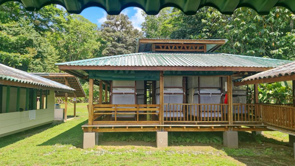
(more of that later), a dining room and a kiosk.

The kiosk is where you can rent a towel, a pair of rubber boots and a locker, all of which Jane and I did – my camera backpack weighs 30lb and I was buggered if I was going to (a) lug it around on a wildlife tour or (b) leave it lying about.  You are obliged to take your shoes off before going on to the station,

so we left our Tevas on the rack, donned boots and were introduced to the chap who would be our private guide for the next day and a half – Angel.

We were due to undertake four guided walks with Angel – two today and two tomorrow.  He proved to be an excellent guide and we saw Lots Of Stuff.  Now that I’ve set the scene, I’ll describe the walks (the “Flights of Angel’s”) in separate posts; I hope you’ll come back to read how they all went and how successful were my attempts to capture the local wildlife.


Rocky Mountain, Hi!

Sunday 4 September 2022 – While we have made it a rule almost everywhere we’ve visited to go for an unstructured wander to explore (sorry, Kamloops – apparently you’re quite interesting after all), today was different in that the wandering would be structured – we were Going Hiking.  With A Guide.

Of course, he wanted to make an early start, so once again we had to tear ourselves from the arms of Morpheus slightly earlier than we might have liked; however, since the day was forecast to be a fairly hot one, an early start was probably best.  We met our guide, Geoff, in the hotel lobby and headed out to find the rest of the group he was leading on the hike. There were supposed to be five others; in the end, there were only four because he actually refused to take one lady on – she was, in his view, totally unprepared – wrong shoes, no backpack, no water. If it was the lady I thought I saw him talking to, he might also have assessed her as being physically the wrong shape to be taking on the hike.

Whatever, the group ended up as being just the six of us – Jane and me and two couples from Boulder, Colorado; Andrea and Dave, Susan and Scott.  Geoff took us about half an hour out of Banff to the trailhead of the Stanley Glacier Trail in East Kootenay, dispensing some wisdom, safety guidelines and information about what we’d let ourselves in for.  He described it as an eight km hike (four out and four back) of moderate toughness, which didn’t sound too daunting; but all the same he spent time making sure we had at least a litre of water each, and provided us with lunch packs.  The schedule for the hike seemed very leisurely – starting before 9am and expecting to be done by about 2 or 2.30pm.

We started up the trail

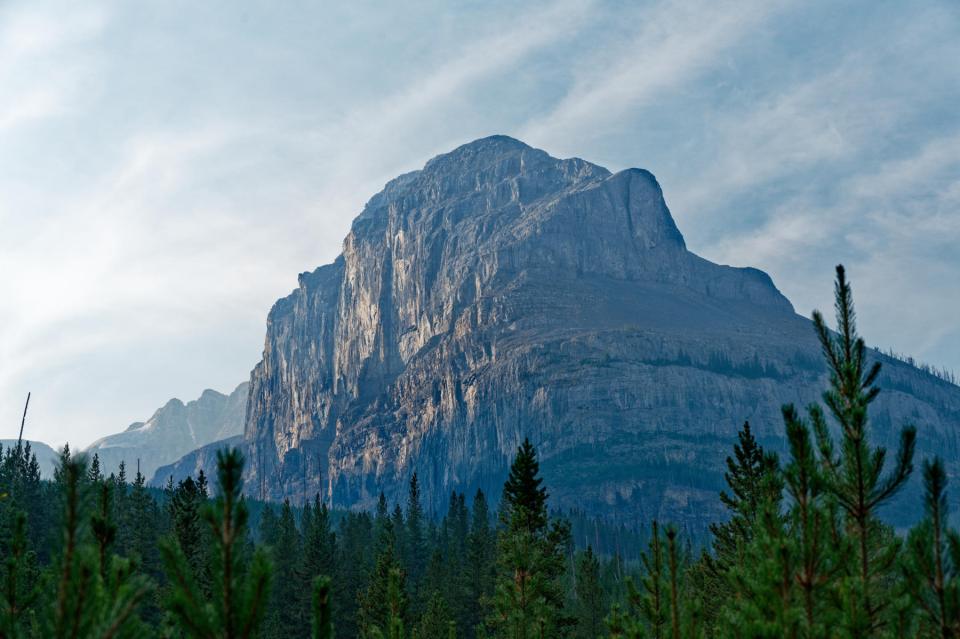
which shows, in the distance the Stanley Head Wall, a face of Mount Stanley (yes, the same Stanley that the Vancouver Park is named for).  The views as we went along were quite striking

but very hazy in places.  Much of the haze is due to wildfire smoke, as wildfires are an important part of the cycle of nature in the Banff national Park as in other parks.  The haze lightened as the day went on but it was, photographically speaking, a challenging day; allow me a geeky photo-type digression, here.

— START OF DIGRESSION: I SHAN’T BE OFFENDED IF YOU SKIP IT —

While modern cameras do a good job of extracting pleasing images from their sensors and presenting them to be viewed on a computer screen, they have to make editorial decisions about the data from the sensor in order to create such an image – so, for example, the .jpg file you see on your mobile phone screen has been extensively edited by the phone.  When I take my Big Camera (Nikon Z6) with me to Take Serious Photos, I decline to have the camera make these decisions for me, as I want a greater degree of control, so I shoot in a format called RAW, which creates an image not immediately readable by a computer without specialist software (DxO Photolab is my go-to) but which has very much more data from the sensor available for the photographer to play with in creating a final image. (In the good old days, one played with bits of cardboard and an enlarger projection on to paper; digital life is much easier.)

The practical upshot is that in challenging conditions such as today, the camera will suggest this as an image with a lot of haze in the background:


whereas I know (because I was there) that there’s much more to the scene than this image shows.  Once I’ve finished tinkering with the RAW file, the image looks like this:

Actually, the processed image is a little clearer than the reality as seen by the human eye; but I’m OK with this – what I’m after is not necessarily a recreation of that reality, but something that  may be more striking.

The net of this rambling is to let you know that I have tinkered with virtually all of the images from the hike to bring out specific elements of the image that I consider important; they are not necessarily a representation of what I saw, but I hope that they go towards telling the story of the hike.

— END OF DIGRESSION —

Geoff

is a very experienced guide, as well as a writer and scientist, and has a wide and detailed knowledge of matters to do with the National Parks of North America;  Yellowstone was the first to be established and Banff was the second. He said that the theme of the hike was “Wildfires and the Forest”, and it was very interesting to hear his perspective on forests, wilderness and managed ecologies.  His philosophy is well expressed by work published in 1995 by one William Cronon called “The Trouble with Wilderness; or, Getting Back to the Wrong Nature.” Cronon said that it was time to rethink wilderness: that the the idea of wilderness as being a place that stands apart from humanity is wrong; and that wilderness – as an area that has no humans in it – is quite profoundly a human creation.

Geoff made a striking assertion: “The forest is doomed”.  A forest is not a permanent entity; bits of it will die from logging, fire or disease.  The cutting back or burning of forests saves the trees from dying of diseases caused by overcrowding and allows the forest to support a wider range of life.  The indigenous peoples that have been in the area for tens of thousands of years knew this, and effectively managed the forests to improve their lives – a greater selection of wildlife which is easier to hunt.  Fire was an important part of this management.

When Europeans came to the area and forced the indigenous peoples out, they lost sight of this; wildfires were regarded as something to be avoided or restricted – absence of wildfires was seen as a success. The result has been overcrowded, diseased forests with a paucity of wildlife, and only now has this realisation sunk in to the extent that proper action is being taken – or, at least, would be, were political will up to the task, which often it isn’t.  A very interesting and counter-intuitive philosophy.

Anyhoo…

We passed some nice scenes of forest and creek

with plentiful evidence of previous forest fires.

Above, you can see the red colours of the fireweed that is first to grow back after a fire.

We met a grouse, unconcernedly pecking away at the path

until disturbed by some people who passed us with a couple of noisy dogs, when it flew up into a nearby tree and posed for us again.

We passed buffalo berry plants

which are prime fodder for grizzly bears.  (Their other mainstay apparently is dandelions – dandelions – not much meat or fish in these here parts). The berries are, apparently, oily but I’m still astonished that berries can sustain an animal as big as a grizzly.  Another name for the berries is soap berries, and if you taste one – carefully, just a little of the juice rather than a whole berry – you can understand why; they have overtones of bitter grapefruit juice and detergent.

After a while, the path got steeper

and we ended up, some 1,000 feet higher than the start, at our lunch spot.  We were first there, but this trail is a popular one and so we were soon joined by others.

This is a big landscape.

In the distance, at the foot of the vertical bit of the Stanley Head Wall, were some climbers.

You can just make out some dots of colour near the white boulder at the bottom of the picture, with two red dots also visible some feet up the wall.  I tried to give some idea of just how big this landscape is.

The distances are deceptive.  For example, the patch of greenery towards the bottom of the picture above doesn’t look that far away,

but, on closer examination, actually has people in it

which are difficult to pick out with the naked eye (well, with my naked eye, anyway).

I tried taking photos of the glacier

and the waterfall caused by its melting

but, as I burbled about above, the light is extremely challenging, and it has taken quite a bit of fiddling to get images that I’m happy with.  I just want you to know that I suffer for my art.

After an hour resting at the top, we retraced our footsteps down the trail.  At the bottom, a stream we had crossed at the start of the trail was showing some lovely glacial blue colour in the water.

And that was it for the hike, which had been a really nice morning – an agreeable temperature, slightly demanding without being ridiculous and giving an opportunity to listen to Geoff’s wisdom about wildlife, ecology and forests.

My Garmin thingy told me, on returning to the hotel and a source of internettery, that we’d expended some 1,300 calories in the course of the hike, which is quite a lot, and could be interpreted as justification for taking it easy for the rest of the day.

So we went for a walk. Obviously.

Geoff had mentioned an area called Bow Falls, which is about half an hour’s walk from downtown Banff.  We needed something to eat anyway, so we headed the 15 minutes to downtown, ate a decent, cheerfully served, early dinner at The Keg, and then headed out along the path towards the falls.

Downtown Banff was busy, probably more than usual because we were here over a Labor Day weekend

but the lower part of the main street has a pedestrian area and is attractive, particularly with the mountains as backdrop.

The path to the falls is a riverside walk, and one has to decide which side of the Bow River to walk on; there’s a pedestrian bridge to help when you’ve made the decision.

We went along the north shore towards the Surprise Corner viewpoint, passing some lovely bits of real estate

almost certainly worth a fortune. At the falls, one gets a pretty spectacular view

part of which is the Fairmont Banff Springs Hotel.

Given that we’ve stayed in Fairmonts in most other places, I assume that this one was full because of the holiday weekend.  Anyway, the sight of the hotel we didn’t stay in complements the splendid view rather well.

We retraced our steps to our hotel.  Along the path is a variety of artworks

including one which is some glass bats in a tree, which is a rather fetching idea.

Banff town itself is quite an attractive place, in a sort of American take on Swiss skiing town way.

And so ended a very pleasant, sunny day, with quite a few miles under our boot vibram and shoe leather.  All that remained was an evening of wedded domestic bliss – me writing the blog and Jane doing the laundry, because These Things Are Important, You Know.

The morrow brings the promise of a ride up the Banff gondola and it will be interesting to see how the logistics of that works – it’s a holiday weekend, so it’ll likely be crowded.  I’ll report back, of course, and I hope you’ll come back to see how it all went.